HydroMorphological assessment and management at basin scale for the Conservation of Alpine Rivers and related Ecosystem Services (Q4300887): Difference between revisions
Jump to navigation
Jump to search
(Created claim: info Regio url (P1742): https://ec.europa.eu/regional_policy/en/projects/europe/hymocares-keeping-alpine-rivers-clean-and-competitive, adding info regio urls (details)) |
(Changed an Item: more data about projects (details)) |
||
| Property / ID used by InfoRegio | |||
4587 | |||
| Property / ID used by InfoRegio: 4587 / rank | |||
Normal rank | |||
| Property / image url | |||
| Property / image url: https://ec.europa.eu/regional_policy/rest/projects/upload/4587.jpg / rank | |||
Normal rank | |||
| Property / image url: https://ec.europa.eu/regional_policy/rest/projects/upload/4587.jpg / qualifier | |||
copyright: Bruno Boz | |||
| Property / image url: https://ec.europa.eu/regional_policy/rest/projects/upload/4587.jpg / qualifier | |||
summary: Alpine river (English) | |||
Revision as of 14:41, 21 September 2022
Project Q4300887 in Switzerland, France, Germany, Italy, Slovenia, Austria
| Language | Label | Description | Also known as |
|---|---|---|---|
| English | HydroMorphological assessment and management at basin scale for the Conservation of Alpine Rivers and related Ecosystem Services |
Project Q4300887 in Switzerland, France, Germany, Italy, Slovenia, Austria |
Statements
2,103,433.38 Euro
0 references
2,596,647.5 Euro
0 references
81.01 percent
0 references
1 November 2016
0 references
30 October 2019
0 references
Civil protection Agency
0 references

52°25'51.82"N, 13°32'3.16"E
0 references

48°44'54.31"N, 2°18'56.02"E
0 references

47°24'28.55"N, 8°30'28.55"E
0 references

48°13'20.39"N, 16°21'5.69"E
0 references

46°4'55.99"N, 14°30'49.68"E
0 references

46°4'3.36"N, 11°7'25.18"E
0 references

48°15'5.18"N, 11°33'28.08"E
0 references

44°33'27.50"N, 6°4'39.43"E
0 references

46°5'44.38"N, 11°7'0.48"E
0 references

48°15'9.47"N, 16°22'10.60"E
0 references

45°29'50.71"N, 12°14'43.73"E
0 references

46°29'40.31"N, 11°19'6.64"E
0 references

46°11'20.83"N, 9°0'59.22"E
0 references
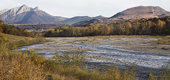
River corridors represent one of the most used and modified landscape elements in the Alps. They provide key ecosystem services (ES), but currently many of them are at risk or significantly degraded. In order to ensure their conservation or restoration, the effects of human uses on ES need to be understood and tackled. In particular, river hydromorphological processes have a key role to ensure habitat maintenance and ecological connectivity and are strongly related to strategic societal challenges such as flood risk mitigation, renewable energy production, biodiversity conservation and ensuring recreational values of Alpine valleys. Suitable approaches are needed to clarify the links between uses, hydromorphological processes and ES availability and to make ES more transparent to the public, support conflict resolution, and design cost-effective mitigation and restoration measures. The project will develop a conceptual framework, currently not available, and operational tools, comprising novel methods, to integrate ES in Alpine river basin planning and management, with a special focus on factors affecting river hydromorphology, including sediment continuity, while ensuring integration of local and basin scales. Particular care will be devoted to identify actual planning, management, operational activities where the proposed approach can be applied and to collaborate directly with relevant actors, both public and private, in order to ensure proper transfer of project outputs and thus a tangible real-scale impact. In order to ensure integration and transferability of the approach to all Alpine countries and to effectively tackle management issues with a clear regional/cross-border component, the consortium includes a transnational network of policy makers, public officers and practitioners in charge of river planning and management at different levels, as well as scientific experts on river hydromorphology and ecology and NGOs. (English)
0 references
0 references
Identifiers
4587
0 references