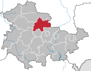
Landkreis Sömmerda (Q2551106): Difference between revisions
Jump to navigation
Jump to search
(Changed an Item: Adding this statements since they where added in Wikidata) |
(Changed an Item: Adding these statements since they where added in Wikidata) |
||||||||||||||
| (13 intermediate revisions by 2 users not shown) | |||||||||||||||
| label / en | label / en | ||||||||||||||
Sömmerda | Landkreis Sömmerda | ||||||||||||||
| label / tr | label / tr | ||||||||||||||
Sömmerda (ilçe) | |||||||||||||||
| description / cs | description / cs | ||||||||||||||
okres ve spolkové zemi Durynsko v Německu | zemský okres ve spolkové zemi Durynsko v Německu | ||||||||||||||
| Property / instance of | |||||||||||||||
| Property / instance of: 2016 NUTS 3 statistical territorial entity / rank | |||||||||||||||
| Property / area | |||||||||||||||
| |||||||||||||||
| Property / area: 806.84 square kilometre / rank | |||||||||||||||
| Property / area: 806.84 square kilometre / qualifier | |||||||||||||||
| |||||||||||||||
| Property / area: 806.84 square kilometre / reference | |||||||||||||||
| Property / population | |||||||||||||||
| |||||||||||||||
| Property / population: 71,005 / rank | |||||||||||||||
| Property / population: 71,005 / reference | |||||||||||||||
| Property / population: 71,005 / reference | |||||||||||||||
| Property / population | |||||||||||||||
| |||||||||||||||
| Property / population: 70,600 / rank | |||||||||||||||
| Property / population: 70,600 / qualifier | |||||||||||||||
| |||||||||||||||
| Property / population: 70,600 / reference | |||||||||||||||
| Property / instance of | |||||||||||||||
| Property / instance of: 2016 NUTS 3 statistical territorial entity / rank | |||||||||||||||
Normal rank | |||||||||||||||
| Property / instance of | |||||||||||||||
| Property / instance of: 2021 NUTS 3 statistical territorial entity / rank | |||||||||||||||
Preferred rank | |||||||||||||||
| Property / area | |||||||||||||||
806.84 square kilometre
| |||||||||||||||
| Property / area: 806.84 square kilometre / rank | |||||||||||||||
Preferred rank | |||||||||||||||
| Property / area: 806.84 square kilometre / qualifier | |||||||||||||||
point in time: 31 December 2015
| |||||||||||||||
| Property / area: 806.84 square kilometre / reference | |||||||||||||||
| Property / GADM ID | |||||||||||||||
DEU.16.17_1 | |||||||||||||||
| Property / GADM ID: DEU.16.17_1 / rank | |||||||||||||||
Normal rank | |||||||||||||||
| Property / flag image | |||||||||||||||
| Property / flag image: Hissflagge Landkreis Sömmerda.svg / rank | |||||||||||||||
Normal rank | |||||||||||||||
| Property / Joconde location ID | |||||||||||||||
T84-3907 | |||||||||||||||
| Property / Joconde location ID: T84-3907 / rank | |||||||||||||||
Normal rank | |||||||||||||||
| Property / population | |||||||||||||||
70,600
| |||||||||||||||
| Property / population: 70,600 / rank | |||||||||||||||
Preferred rank | |||||||||||||||
| Property / population: 70,600 / qualifier | |||||||||||||||
point in time: 31 December 2015
| |||||||||||||||
| Property / population: 70,600 / reference | |||||||||||||||
| Property / museum-digital place ID | |||||||||||||||
5787 | |||||||||||||||
| Property / museum-digital place ID: 5787 / rank | |||||||||||||||
Normal rank | |||||||||||||||
| Property / museum-digital place ID: 5787 / reference | |||||||||||||||
| Property / National Library of Israel J9U ID | |||||||||||||||
987007560188705171 | |||||||||||||||
| Property / National Library of Israel J9U ID: 987007560188705171 / rank | |||||||||||||||
Normal rank | |||||||||||||||
| Property / National Library of Israel J9U ID: 987007560188705171 / reference | |||||||||||||||
| Property / EU Knowledge Graph item ID | |||||||||||||||
Q2551106 | |||||||||||||||
| Property / EU Knowledge Graph item ID: Q2551106 / rank | |||||||||||||||
Normal rank | |||||||||||||||
Latest revision as of 11:55, 4 October 2022
district in Thuringia, Germany
| Language | Label | Description | Also known as |
|---|---|---|---|
| English | Landkreis Sömmerda |
district in Thuringia, Germany |
Statements
806.84 square kilometre
31 December 2015
1 reference
70,600
31 December 2015
1 reference
Identifiers
3 references
2--432243
0 references
DE.TH.SD
0 references
DEU.16.17_1
0 references
T84-3907
0 references
987007560188705171
Q2551106
0 references


