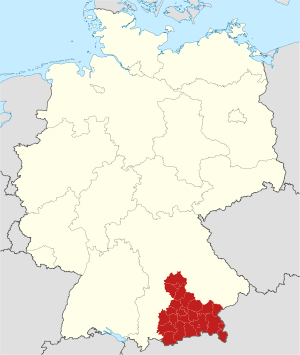
Upper Bavaria (Q2501880): Difference between revisions

From EU Knowledge Graph
Jump to navigation Jump to search
(‎Changed an Item: Adding this statements since they where added in Wikidata)
Property / contains administrative territorial entity
 
Property / contains administrative territorial entity: Eichstätt / rank
 
Normal rank
Property / contains administrative territorial entity
 
Property / contains administrative territorial entity: Erding / rank
 
Normal rank
Property / contains administrative territorial entity
 
Property / contains administrative territorial entity: Freising / rank
 
Normal rank
Property / contains administrative territorial entity
 
Property / contains administrative territorial entity: Fürstenfeldbruck / rank
 
Normal rank
Property / contains administrative territorial entity
 
Property / contains administrative territorial entity: Garmisch-Partenkirchen / rank
 
Normal rank
Property / contains administrative territorial entity
 
Property / contains administrative territorial entity: Landsberg am Lech / rank
 
Normal rank
Property / contains administrative territorial entity
 
Property / contains administrative territorial entity: Miesbach / rank
 
Normal rank
Property / contains administrative territorial entity
 
Property / contains administrative territorial entity: Mühldorf / rank
 
Normal rank
Property / contains administrative territorial entity
 
Property / contains administrative territorial entity: Munich (district) / rank
 
Normal rank
Property / contains administrative territorial entity
 
Property / contains administrative territorial entity: Neuburg-Schrobenhausen / rank
 
Normal rank
Property / contains administrative territorial entity
 
Property / contains administrative territorial entity: Pfaffenhofen a. d. Ilm / rank
 
Normal rank
Property / contains administrative territorial entity
 
Property / contains administrative territorial entity: Rosenheim / rank
 
Normal rank
Property / contains administrative territorial entity
 
Property / contains administrative territorial entity: Starnberg district / rank
 
Normal rank
Property / contains administrative territorial entity
 
Property / contains administrative territorial entity: Traunstein / rank
 
Normal rank
Property / contains administrative territorial entity
 
Property / contains administrative territorial entity: Weilheim-Schongau / rank
 
Normal rank
Property / flag image
 
Property / flag image: Flagge Oberbayern.svg / rank
 
Normal rank
Property / coordinate location
 
48°7'59.9"N, 11°34'0.1"E
Latitude48.133333
Longitude11.566667
Precision0.0001
Globehttp://www.wikidata.org/entity/Q2
Property / coordinate location: 48°7'59.9"N, 11°34'0.1"E / rank
 
Normal rank
Property / coordinate location: 48°7'59.9"N, 11°34'0.1"E / reference
 
Property / topic's main category
 
Property / topic's main category: Category:Upper Bavaria / rank
 
Normal rank
Property / GND ID
 
Property / GND ID: 4042884-9 / rank
 
Normal rank
Property / GND ID: 4042884-9 / reference
 
Property / instance of
 
Property / instance of: Regierungsbezirk / rank
 
Normal rank

Revision as of 16:02, 3 July 2020

administrative regions of Bavaria, Germany
  • Oberbayern
  • Regierungsbezirk Oberbayern
Language Label Description Also known as
English
Upper Bavaria
administrative regions of Bavaria, Germany
  • Oberbayern
  • Regierungsbezirk Oberbayern

Statements

0 references
0 references
P169 (Deleted Property)
2--4336 Property P169 not found, cannot determine the data type to use.
0 references
0 references
Wappen Oberbayern.svg
192 × 216; 240 KB
0 references
0 references
0 references
0 references
0 references
0 references
0 references
0 references
0 references
0 references
0 references
0 references
0 references
0 references
0 references
0 references
0 references
0 references
0 references
0 references
0 references
0 references
0 references
0 references
0 references
Flagge Oberbayern.svg
900 × 600; 304 KB
0 references

Identifiers