File:Karte NOE Viertel Bezirke.svg
Jump to navigation
Jump to search


Size of this PNG preview of this SVG file: 666 × 599 pixels. Other resolutions: 267 × 240 pixels | 533 × 480 pixels | 853 × 768 pixels | 1,138 × 1,024 pixels | 2,276 × 2,048 pixels | 1,000 × 900 pixels.
Original file (SVG file, nominally 1,000 × 900 pixels, file size: 82 KB)
Summary
| Description |
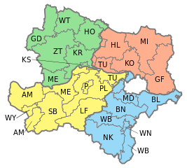
English: Map of Lower Austria showing districts with different colors for Waldviertel, Weinviertel, Mostviertel and Industrieviertel.
Deutsch: Karte von Niederösterreich, eingezeichnet die Bezirke und die vier Viertel: Waldviertel, Weinviertel, Mostviertel und Industrieviertel.
Waldviertel
Weinviertel
Mostviertel
Industrieviertel |
| Date | |
| Source | Own work, based on [1] |
| Author | AleXXw |
| Other versions |
|


![[1]](http://www.noe.gv.at/bilder/d17/BD5noe31-Viertelsgrenzen.png?7150)
Licensing
| I, the copyright holder of this work, release this work into the public domain. This applies worldwide. In some countries this may not be legally possible; if so: I grant anyone the right to use this work for any purpose, without any conditions, unless such conditions are required by law. |
File history
Click on a date/time to view the file as it appeared at that time.
| Date/Time | Thumbnail | Dimensions | User | Comment | |
|---|---|---|---|---|---|
| current | 15:26, 4 February 2017 | | 1,000 × 900 (82 KB) | wikimediacommons>Ailura | Versuch ohne WU |
File usage
The following 2 pages use this file: