Porcari (Q262856): Difference between revisions
Jump to navigation
Jump to search
(Changed an Item: Adding this statements since they where added in Wikidata) |
(Changed an Item: Adding this statements since they where added in Wikidata) |
||||||||||||||
| Property / GeoNames ID | |||||||||||||||
| Property / GeoNames ID: 6540465 / rank | |||||||||||||||
Normal rank | |||||||||||||||
| Property / GeoNames ID: 6540465 / reference | |||||||||||||||
| Property / topic's main category | |||||||||||||||
| Property / topic's main category: Category:Porcari / rank | |||||||||||||||
Normal rank | |||||||||||||||
| Property / topic's main category: Category:Porcari / reference | |||||||||||||||
| Property / VIAF ID | |||||||||||||||
| Property / VIAF ID: 234310225 / rank | |||||||||||||||
Normal rank | |||||||||||||||
| Property / VIAF ID: 234310225 / reference | |||||||||||||||
| Property / VIAF ID: 234310225 / reference | |||||||||||||||
retrieved: 3 August 2015
| |||||||||||||||
| Property / elevation above sea level | |||||||||||||||
32±1 metre
| |||||||||||||||
| Property / elevation above sea level: 32±1 metre / rank | |||||||||||||||
Normal rank | |||||||||||||||
| Property / elevation above sea level: 32±1 metre / reference | |||||||||||||||
| Property / official website | |||||||||||||||
| Property / official website: http://www.comune.porcari.lu.it/ / rank | |||||||||||||||
Normal rank | |||||||||||||||
| Property / official website: http://www.comune.porcari.lu.it/ / reference | |||||||||||||||
| Property / licence plate code | |||||||||||||||
LU | |||||||||||||||
| Property / licence plate code: LU / rank | |||||||||||||||
Normal rank | |||||||||||||||
| Property / coordinates of northernmost point | |||||||||||||||
43°51'37.264"N, 10°36'28.606"E
| |||||||||||||||
| Property / coordinates of northernmost point: 43°51'37.264"N, 10°36'28.606"E / rank | |||||||||||||||
Normal rank | |||||||||||||||
| Property / coordinates of northernmost point: 43°51'37.264"N, 10°36'28.606"E / reference | |||||||||||||||
| Property / coordinates of southernmost point | |||||||||||||||
43°47'37.158"N, 10°36'54.418"E
| |||||||||||||||
| Property / coordinates of southernmost point: 43°47'37.158"N, 10°36'54.418"E / rank | |||||||||||||||
Normal rank | |||||||||||||||
| Property / coordinates of southernmost point: 43°47'37.158"N, 10°36'54.418"E / reference | |||||||||||||||
| Property / coordinates of easternmost point | |||||||||||||||
43°50'49.074"N, 10°38'30.498"E
| |||||||||||||||
| Property / coordinates of easternmost point: 43°50'49.074"N, 10°38'30.498"E / rank | |||||||||||||||
Normal rank | |||||||||||||||
| Property / coordinates of easternmost point: 43°50'49.074"N, 10°38'30.498"E / reference | |||||||||||||||
| Property / coordinates of westernmost point | |||||||||||||||
43°48'44.586"N, 10°35'44.844"E
| |||||||||||||||
| Property / coordinates of westernmost point: 43°48'44.586"N, 10°35'44.844"E / rank | |||||||||||||||
Normal rank | |||||||||||||||
| Property / coordinates of westernmost point: 43°48'44.586"N, 10°35'44.844"E / reference | |||||||||||||||
| Property / OSM relation ID | |||||||||||||||
| Property / OSM relation ID: 42667 / rank | |||||||||||||||
Normal rank | |||||||||||||||
| Property / capital | |||||||||||||||
| Property / capital: Porcari / rank | |||||||||||||||
Normal rank | |||||||||||||||
| Property / GND ID | |||||||||||||||
| Property / GND ID: 4364565-3 / rank | |||||||||||||||
Normal rank | |||||||||||||||
| Property / GND ID: 4364565-3 / reference | |||||||||||||||
| Property / area | |||||||||||||||
18.05 square kilometre
| |||||||||||||||
| Property / area: 18.05 square kilometre / rank | |||||||||||||||
Normal rank | |||||||||||||||
| Property / area: 18.05 square kilometre / qualifier | |||||||||||||||
point in time: 9 October 2011
| |||||||||||||||
| Property / area: 18.05 square kilometre / reference | |||||||||||||||
| Property / area: 18.05 square kilometre / reference | |||||||||||||||
| Property / area: 18.05 square kilometre / reference | |||||||||||||||
title: Superficie di Comuni Province e Regioni italiane al 9 ottobre 2011 (Italian) | |||||||||||||||
| Property / area: 18.05 square kilometre / reference | |||||||||||||||
retrieved: 16 March 2019
| |||||||||||||||
| Property / area: 18.05 square kilometre / reference | |||||||||||||||
| Property / population | |||||||||||||||
8,868
| |||||||||||||||
| Property / population: 8,868 / rank | |||||||||||||||
Normal rank | |||||||||||||||
| Property / population: 8,868 / qualifier | |||||||||||||||
point in time: 1 January 2017
| |||||||||||||||
| Property / population: 8,868 / qualifier | |||||||||||||||
| Property / population: 8,868 / reference | |||||||||||||||
| Property / population | |||||||||||||||
8,904
| |||||||||||||||
| Property / population: 8,904 / rank | |||||||||||||||
Preferred rank | |||||||||||||||
| Property / population: 8,904 / qualifier | |||||||||||||||
point in time: 1 January 2018
| |||||||||||||||
| Property / population: 8,904 / qualifier | |||||||||||||||
| Property / population: 8,904 / reference | |||||||||||||||
| Property / population: 8,904 / reference | |||||||||||||||
title: Popolazione Residente al 1° Gennaio 2018 (Italian) | |||||||||||||||
| Property / population: 8,904 / reference | |||||||||||||||
retrieved: 16 March 2019
| |||||||||||||||
| Property / population: 8,904 / reference | |||||||||||||||
| Property / UN/LOCODE | |||||||||||||||
| Property / UN/LOCODE: ITPOC / rank | |||||||||||||||
Normal rank | |||||||||||||||
| Property / IndicePA ID | |||||||||||||||
| Property / IndicePA ID: c_g882 / rank | |||||||||||||||
Normal rank | |||||||||||||||
| Property / Who's on First ID | |||||||||||||||
| Property / Who's on First ID: 101837173 / rank | |||||||||||||||
Normal rank | |||||||||||||||
| Property / WorldCat Identities ID | |||||||||||||||
viaf-234310225 | |||||||||||||||
| Property / WorldCat Identities ID: viaf-234310225 / rank | |||||||||||||||
Normal rank | |||||||||||||||
| Property / WorldCat Identities ID: viaf-234310225 / reference | |||||||||||||||
Revision as of 00:58, 6 August 2020
Italian comune
| Language | Label | Description | Also known as |
|---|---|---|---|
| English | Porcari |
Italian comune |
Statements


Q2608299 (Deleted Item)
0 references
Porcari
0 references
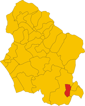
.svg)
Map of comune of Porcari (province of Lucca, region Tuscany, Italy).svg
4,176 × 5,190; 77 KB
4,176 × 5,190; 77 KB
1 reference

LU
0 references


18.05 square kilometre
9 October 2011
5 references
Superficie di Comuni Province e Regioni italiane al 9 ottobre 2011 (Italian)
16 March 2019
8,868
1 January 2017
1 reference
8,904
1 January 2018
4 references
Popolazione Residente al 1° Gennaio 2018 (Italian)
16 March 2019
Identifiers
383070463
0 references
2--4553
0 references