Dolo (Q262346): Difference between revisions
Jump to navigation
Jump to search
(Changed label, description and/or aliases in 1 language: Aliases in wikidata changed) |
(Changed label, description and/or aliases in tr: The description in Wikidata changed) |
||||||||||||||
| (42 intermediate revisions by 2 users not shown) | |||||||||||||||
| label / el | label / el | ||||||||||||||
Ντόλο | |||||||||||||||
| label / ga | label / ga | ||||||||||||||
Dolo | |||||||||||||||
| description / en | description / en | ||||||||||||||
Italian comune | |||||||||||||||
| description / it | description / it | ||||||||||||||
comune italiano | |||||||||||||||
| description / bg | description / bg | ||||||||||||||
италианска община | |||||||||||||||
| description / cs | description / cs | ||||||||||||||
italská obec | |||||||||||||||
| description / de | description / de | ||||||||||||||
italienische Gemeinde in Venetien | |||||||||||||||
| description / el | description / el | ||||||||||||||
δήμος της Ιταλίας | |||||||||||||||
| description / es | description / es | ||||||||||||||
municipio italiano | |||||||||||||||
| description / fr | description / fr | ||||||||||||||
commune italienne | |||||||||||||||
| description / hr | description / hr | ||||||||||||||
Talijanske općine | |||||||||||||||
| description / lt | description / lt | ||||||||||||||
komuna Italijoje | |||||||||||||||
| description / nl | description / nl | ||||||||||||||
Italiaanse gemeente | |||||||||||||||
| description / pl | description / pl | ||||||||||||||
włoska gmina | |||||||||||||||
| description / pt | description / pt | ||||||||||||||
comuna italiana | |||||||||||||||
| description / sv | description / sv | ||||||||||||||
kommun i Italien | |||||||||||||||
| description / tr | description / tr | ||||||||||||||
İtalya'nın Veneto bölgesinde, Venedik iline bağlı ilçe (komün) | |||||||||||||||
| description / ro | description / ro | ||||||||||||||
comună din Italia | |||||||||||||||
| description / fi | description / fi | ||||||||||||||
kunta Italiassa | |||||||||||||||
| description / hu | description / hu | ||||||||||||||
település Olaszországban | |||||||||||||||
| Property / country | |||||||||||||||
| Property / country: Italy / rank | |||||||||||||||
| Property / instance of | |||||||||||||||
| Property / instance of: beneficiary / rank | |||||||||||||||
| Property / instance of | |||||||||||||||
| Property / instance of: commune of Italy / rank | |||||||||||||||
Normal rank | |||||||||||||||
| Property / instance of | |||||||||||||||
| Property / instance of: beneficiary / rank | |||||||||||||||
Preferred rank | |||||||||||||||
| Property / instance of | |||||||||||||||
| Property / instance of: public beneficiary / rank | |||||||||||||||
Normal rank | |||||||||||||||
| Property / instance of: public beneficiary / qualifier | |||||||||||||||
| Property / Commons category | |||||||||||||||
Dolo, Veneto | |||||||||||||||
| Property / Commons category: Dolo, Veneto / rank | |||||||||||||||
Normal rank | |||||||||||||||
| Property / located in the administrative territorial entity | |||||||||||||||
| Property / located in the administrative territorial entity: Province of Venice / rank | |||||||||||||||
Normal rank | |||||||||||||||
| Property / located in the administrative territorial entity: Province of Venice / qualifier | |||||||||||||||
end time: 30 August 2015
| |||||||||||||||
| Property / located in the administrative territorial entity: Province of Venice / reference | |||||||||||||||
| Property / located in the administrative territorial entity | |||||||||||||||
| Property / located in the administrative territorial entity: Metropolitan City of Venice / rank | |||||||||||||||
Preferred rank | |||||||||||||||
| Property / located in the administrative territorial entity: Metropolitan City of Venice / qualifier | |||||||||||||||
start time: 31 August 2015
| |||||||||||||||
| Property / located in the administrative territorial entity: Metropolitan City of Venice / qualifier | |||||||||||||||
| Property / shares border with | |||||||||||||||
| Property / shares border with: Pianiga / rank | |||||||||||||||
Normal rank | |||||||||||||||
| Property / shares border with: Pianiga / reference | |||||||||||||||
| Property / shares border with | |||||||||||||||
| Property / shares border with: Stra / rank | |||||||||||||||
Normal rank | |||||||||||||||
| Property / shares border with | |||||||||||||||
| Property / shares border with: Campagna Lupia / rank | |||||||||||||||
Normal rank | |||||||||||||||
| Property / shares border with: Campagna Lupia / reference | |||||||||||||||
| Property / shares border with | |||||||||||||||
| Property / shares border with: Camponogara / rank | |||||||||||||||
Normal rank | |||||||||||||||
| Property / shares border with: Camponogara / reference | |||||||||||||||
| Property / shares border with | |||||||||||||||
| Property / shares border with: Mira / rank | |||||||||||||||
Normal rank | |||||||||||||||
| Property / shares border with: Mira / reference | |||||||||||||||
| Property / shares border with | |||||||||||||||
| Property / shares border with: Fiesso d'Artico / rank | |||||||||||||||
Normal rank | |||||||||||||||
| Property / shares border with: Fiesso d'Artico / reference | |||||||||||||||
| Property / shares border with | |||||||||||||||
| Property / shares border with: Fossò / rank | |||||||||||||||
Normal rank | |||||||||||||||
| Property / shares border with: Fossò / reference | |||||||||||||||
| Property / image | |||||||||||||||
| Property / image: DoloVenezia.jpg / rank | |||||||||||||||
Normal rank | |||||||||||||||
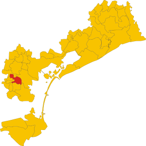
| Property / locator map image | |||||||||||||||
| Property / locator map image: Map of comune of Dolo (province of Venice, region Veneto, Italy).svg / rank | |||||||||||||||
Normal rank | |||||||||||||||
| Property / locator map image: Map of comune of Dolo (province of Venice, region Veneto, Italy).svg / reference | |||||||||||||||
| Property / postal code | |||||||||||||||
30031 | |||||||||||||||
| Property / postal code: 30031 / rank | |||||||||||||||
Normal rank | |||||||||||||||
| Property / located in time zone | |||||||||||||||
| Property / located in time zone: UTC+01:00 / rank | |||||||||||||||
Normal rank | |||||||||||||||
| Property / located in time zone: UTC+01:00 / qualifier | |||||||||||||||
| Property / located in time zone: UTC+01:00 / reference | |||||||||||||||
| Property / located in time zone | |||||||||||||||
| Property / located in time zone: UTC+02:00 / rank | |||||||||||||||
Normal rank | |||||||||||||||
| Property / located in time zone: UTC+02:00 / qualifier | |||||||||||||||
| Property / ISTAT ID | |||||||||||||||
027012 | |||||||||||||||
| Property / ISTAT ID: 027012 / rank | |||||||||||||||
Normal rank | |||||||||||||||
| Property / ISTAT ID: 027012 / reference | |||||||||||||||
| Property / coordinate location | |||||||||||||||
45°25'29.57"N, 12°4'32.92"E
| |||||||||||||||
| Property / coordinate location: 45°25'29.57"N, 12°4'32.92"E / rank | |||||||||||||||
Normal rank | |||||||||||||||
| Property / country | |||||||||||||||
| Property / country: Italy / rank | |||||||||||||||
Normal rank | |||||||||||||||
| Property / country: Italy / reference | |||||||||||||||
| Property / local dialing code | |||||||||||||||
041 | |||||||||||||||
| Property / local dialing code: 041 / rank | |||||||||||||||
Normal rank | |||||||||||||||
| Property / local dialing code: 041 / reference | |||||||||||||||
| Property / Italian cadastre code | |||||||||||||||
D325 | |||||||||||||||
| Property / Italian cadastre code: D325 / rank | |||||||||||||||
Normal rank | |||||||||||||||
| Property / Italian cadastre code: D325 / reference | |||||||||||||||
| Property / official website | |||||||||||||||
| Property / official website: http://www.comune.dolo.ve.it/ / rank | |||||||||||||||
Normal rank | |||||||||||||||
| Property / official website: http://www.comune.dolo.ve.it/ / reference | |||||||||||||||
| Property / Freebase ID | |||||||||||||||
| Property / Freebase ID: /m/0g9f56 / rank | |||||||||||||||
Normal rank | |||||||||||||||
| Property / Freebase ID: /m/0g9f56 / reference | |||||||||||||||
| Property / Freebase ID: /m/0g9f56 / reference | |||||||||||||||
publication date: 28 October 2013
| |||||||||||||||
| Property / GeoNames ID | |||||||||||||||
| Property / GeoNames ID: 6536660 / rank | |||||||||||||||
Normal rank | |||||||||||||||
| Property / GeoNames ID: 6536660 / reference | |||||||||||||||
| Property / category for people who died here | |||||||||||||||
| Property / category for people who died here: Category:Deaths in Dolo / rank | |||||||||||||||
Normal rank | |||||||||||||||
| Property / category for people who died here: Category:Deaths in Dolo / reference | |||||||||||||||
| Property / category for people born here | |||||||||||||||
| Property / category for people born here: Q2601780 / rank | |||||||||||||||
Normal rank | |||||||||||||||
| Property / category for people born here: Q2601780 / reference | |||||||||||||||
| Property / MusicBrainz area ID | |||||||||||||||
| Property / MusicBrainz area ID: cb880f96-0229-482f-9cb2-5908c30c45ac / rank | |||||||||||||||
Normal rank | |||||||||||||||
| Property / MusicBrainz area ID: cb880f96-0229-482f-9cb2-5908c30c45ac / reference | |||||||||||||||
| Property / topic's main category | |||||||||||||||
| Property / topic's main category: Category:Dolo (Italy) / rank | |||||||||||||||
Normal rank | |||||||||||||||
| Property / topic's main category: Category:Dolo (Italy) / reference | |||||||||||||||
| Property / Digital Atlas of the Roman Empire ID | |||||||||||||||
| Property / Digital Atlas of the Roman Empire ID: 17836 / rank | |||||||||||||||
Normal rank | |||||||||||||||
| Property / elevation above sea level | |||||||||||||||
7±1 metre
| |||||||||||||||
| Property / elevation above sea level: 7±1 metre / rank | |||||||||||||||
Normal rank | |||||||||||||||
| Property / elevation above sea level: 7±1 metre / reference | |||||||||||||||
| Property / category of associated people | |||||||||||||||
| Property / category of associated people: Category:People of Dolo / rank | |||||||||||||||
Normal rank | |||||||||||||||
| Property / coordinates of northernmost point | |||||||||||||||
45°27'2.138"N, 12°2'32.082"E
| |||||||||||||||
| Property / coordinates of northernmost point: 45°27'2.138"N, 12°2'32.082"E / rank | |||||||||||||||
Normal rank | |||||||||||||||
| Property / coordinates of northernmost point: 45°27'2.138"N, 12°2'32.082"E / reference | |||||||||||||||
| Property / coordinates of southernmost point | |||||||||||||||
45°23'29.576"N, 12°7'27.199"E
| |||||||||||||||
| Property / coordinates of southernmost point: 45°23'29.576"N, 12°7'27.199"E / rank | |||||||||||||||
Normal rank | |||||||||||||||
| Property / coordinates of southernmost point: 45°23'29.576"N, 12°7'27.199"E / reference | |||||||||||||||
| Property / coordinates of easternmost point | |||||||||||||||
45°24'47.336"N, 12°7'54.538"E
| |||||||||||||||
| Property / coordinates of easternmost point: 45°24'47.336"N, 12°7'54.538"E / rank | |||||||||||||||
Normal rank | |||||||||||||||
| Property / coordinates of easternmost point: 45°24'47.336"N, 12°7'54.538"E / reference | |||||||||||||||
| Property / coordinates of westernmost point | |||||||||||||||
45°26'1.666"N, 12°2'9.089"E
| |||||||||||||||
| Property / coordinates of westernmost point: 45°26'1.666"N, 12°2'9.089"E / rank | |||||||||||||||
Normal rank | |||||||||||||||
| Property / coordinates of westernmost point: 45°26'1.666"N, 12°2'9.089"E / reference | |||||||||||||||
| Property / OSM relation ID | |||||||||||||||
| Property / OSM relation ID: 44922 / rank | |||||||||||||||
Normal rank | |||||||||||||||
| Property / area | |||||||||||||||
24.28 square kilometre
| |||||||||||||||
| Property / area: 24.28 square kilometre / rank | |||||||||||||||
Normal rank | |||||||||||||||
| Property / area: 24.28 square kilometre / qualifier | |||||||||||||||
point in time: 9 October 2011
| |||||||||||||||
| Property / area: 24.28 square kilometre / reference | |||||||||||||||
| Property / area: 24.28 square kilometre / reference | |||||||||||||||
| Property / area: 24.28 square kilometre / reference | |||||||||||||||
title: Superficie di Comuni Province e Regioni italiane al 9 ottobre 2011 (Italian) | |||||||||||||||
| Property / area: 24.28 square kilometre / reference | |||||||||||||||
retrieved: 16 March 2019
| |||||||||||||||
| Property / area: 24.28 square kilometre / reference | |||||||||||||||
| Property / population | |||||||||||||||
14,953
| |||||||||||||||
| Property / population: 14,953 / rank | |||||||||||||||
Normal rank | |||||||||||||||
| Property / population: 14,953 / qualifier | |||||||||||||||
point in time: 1 January 2017
| |||||||||||||||
| Property / population: 14,953 / qualifier | |||||||||||||||
| Property / population: 14,953 / reference | |||||||||||||||
| Property / population | |||||||||||||||
15,022
| |||||||||||||||
| Property / population: 15,022 / rank | |||||||||||||||
Preferred rank | |||||||||||||||
| Property / population: 15,022 / qualifier | |||||||||||||||
point in time: 1 January 2018
| |||||||||||||||
| Property / population: 15,022 / qualifier | |||||||||||||||
| Property / population: 15,022 / reference | |||||||||||||||
| Property / population: 15,022 / reference | |||||||||||||||
title: Popolazione Residente al 1° Gennaio 2018 (Italian) | |||||||||||||||
| Property / population: 15,022 / reference | |||||||||||||||
retrieved: 16 March 2019
| |||||||||||||||
| Property / population: 15,022 / reference | |||||||||||||||
| Property / UN/LOCODE | |||||||||||||||
| Property / UN/LOCODE: ITDOL / rank | |||||||||||||||
Normal rank | |||||||||||||||
| Property / licence plate code | |||||||||||||||
VE | |||||||||||||||
| Property / licence plate code: VE / rank | |||||||||||||||
Normal rank | |||||||||||||||
| Property / IndicePA ID | |||||||||||||||
| Property / IndicePA ID: c_d325 / rank | |||||||||||||||
Normal rank | |||||||||||||||
| Property / Gran Enciclopèdia Catalana ID | |||||||||||||||
| Property / Gran Enciclopèdia Catalana ID: 0264793 / rank | |||||||||||||||
Normal rank | |||||||||||||||
| Property / Who's on First ID | |||||||||||||||
| Property / Who's on First ID: 101757959 / rank | |||||||||||||||
Normal rank | |||||||||||||||
| Property / Wiki Loves Monuments ID | |||||||||||||||
05D3250000 | |||||||||||||||
| Property / Wiki Loves Monuments ID: 05D3250000 / rank | |||||||||||||||
Normal rank | |||||||||||||||
| Property / Wiki Loves Monuments ID: 05D3250000 / qualifier | |||||||||||||||
start time: 1 September 2020
| |||||||||||||||
| Property / Wiki Loves Monuments ID: 05D3250000 / reference | |||||||||||||||
| Property / patron saint | |||||||||||||||
| Property / patron saint: Roch / rank | |||||||||||||||
Normal rank | |||||||||||||||
| Property / patron saint: Roch / reference | |||||||||||||||
| Property / patron saint: Roch / reference | |||||||||||||||
| Property / GND ID | |||||||||||||||
| Property / GND ID: 10092798-1 / rank | |||||||||||||||
Normal rank | |||||||||||||||
| Property / GND ID | |||||||||||||||
| Property / GND ID: 4608540-3 / rank | |||||||||||||||
Preferred rank | |||||||||||||||
| Property / VIAF ID | |||||||||||||||
| Property / VIAF ID: 244290385 / rank | |||||||||||||||
Normal rank | |||||||||||||||
| Property / Köppen climate classification | |||||||||||||||
| Property / Köppen climate classification: humid subtropical climate / rank | |||||||||||||||
Normal rank | |||||||||||||||
| Property / male population | |||||||||||||||
7,314
| |||||||||||||||
| Property / male population: 7,314 / rank | |||||||||||||||
Normal rank | |||||||||||||||
| Property / male population: 7,314 / qualifier | |||||||||||||||
| Property / male population | |||||||||||||||
7,314
| |||||||||||||||
| Property / male population: 7,314 / rank | |||||||||||||||
Normal rank | |||||||||||||||
| Property / male population: 7,314 / reference | |||||||||||||||
| Property / female population | |||||||||||||||
7,739
| |||||||||||||||
| Property / female population: 7,739 / rank | |||||||||||||||
Normal rank | |||||||||||||||
| Property / female population: 7,739 / qualifier | |||||||||||||||
| Property / female population | |||||||||||||||
7,739
| |||||||||||||||
| Property / female population: 7,739 / rank | |||||||||||||||
Normal rank | |||||||||||||||
| Property / female population: 7,739 / reference | |||||||||||||||
| Property / part of | |||||||||||||||
| Property / part of: Q3991939 / rank | |||||||||||||||
Normal rank | |||||||||||||||
| Property / seismic classification | |||||||||||||||
| Property / seismic classification: 3 / rank | |||||||||||||||
Normal rank | |||||||||||||||
| Property / seismic classification: 3 / reference | |||||||||||||||
| Property / seismic classification: 3 / reference | |||||||||||||||
| Property / seismic classification: 3 / reference | |||||||||||||||
retrieved: 27 August 2022
| |||||||||||||||
| Property / EU Knowledge Graph item ID | |||||||||||||||
Q262346 | |||||||||||||||
| Property / EU Knowledge Graph item ID: Q262346 / rank | |||||||||||||||
Normal rank | |||||||||||||||
| Property / OpenWeatherMap city ID | |||||||||||||||
| Property / OpenWeatherMap city ID: 3177547 / rank | |||||||||||||||
Normal rank | |||||||||||||||
| Property / coat of arms image | |||||||||||||||
| Property / coat of arms image: Dolo (Italia)-Stemma.svg / rank | |||||||||||||||
Normal rank | |||||||||||||||
| Property / FactGrid item ID | |||||||||||||||
Q513333 | |||||||||||||||
| Property / FactGrid item ID: Q513333 / rank | |||||||||||||||
Normal rank | |||||||||||||||
| links / bgwiki / name | links / bgwiki / name | ||||||||||||||
| links / cswiki / name | links / cswiki / name | ||||||||||||||
| links / dewiki / name | links / dewiki / name | ||||||||||||||
| links / enwiki / name | links / enwiki / name | ||||||||||||||
| links / eswiki / name | links / eswiki / name | ||||||||||||||
| links / frwiki / name | links / frwiki / name | ||||||||||||||
| links / huwiki / name | links / huwiki / name | ||||||||||||||
| links / itwiki / name | links / itwiki / name | ||||||||||||||
| links / nlwiki / name | links / nlwiki / name | ||||||||||||||
| links / plwiki / name | links / plwiki / name | ||||||||||||||
| links / ptwiki / name | links / ptwiki / name | ||||||||||||||
| links / rowiki / name | links / rowiki / name | ||||||||||||||
| links / svwiki / name | links / svwiki / name | ||||||||||||||
| links / trwiki / name | links / trwiki / name | ||||||||||||||
Latest revision as of 10:35, 4 February 2024
Italian comune
| Language | Label | Description | Also known as |
|---|---|---|---|
| English | Dolo |
Italian comune |
Statements

45°25'29.57"N, 12°4'32.92"E
0 references
30031
0 references
Dolo, Veneto
0 references
30 August 2015
1 reference
31 August 2015
0 references

.svg)
Map of comune of Dolo (province of Venice, region Veneto, Italy).svg
4,120 × 4,131; 126 KB
4,120 × 4,131; 126 KB
1 reference


24.28 square kilometre
9 October 2011
5 references
Superficie di Comuni Province e Regioni italiane al 9 ottobre 2011 (Italian)
16 March 2019
14,953
1 January 2017
1 reference
15,022
1 January 2018
4 references
Popolazione Residente al 1° Gennaio 2018 (Italian)
16 March 2019
VE
0 references
-Stemma.svg)
.svg)
-Stemma.svg)
Identifiers
82001910270
0 references
Q262346
0 references
Q513333
0 references