Manfredonia (Q258155): Difference between revisions
Jump to navigation
Jump to search
(Changed an Item: Adding this statements since they where added in Wikidata) |
(Changed an Item: Adding this statements since they where added in Wikidata) |
||||||||||||||
| Property / coordinates of westernmost point | |||||||||||||||
41°29'11.702"N, 15°41'22.906"E
| |||||||||||||||
| Property / coordinates of westernmost point: 41°29'11.702"N, 15°41'22.906"E / rank | |||||||||||||||
Normal rank | |||||||||||||||
| Property / coordinates of westernmost point: 41°29'11.702"N, 15°41'22.906"E / reference | |||||||||||||||
| Property / OSM relation ID | |||||||||||||||
| Property / OSM relation ID: 41273 / rank | |||||||||||||||
Normal rank | |||||||||||||||
| Property / Quora topic ID | |||||||||||||||
| Property / Quora topic ID: Manfredonia / rank | |||||||||||||||
Normal rank | |||||||||||||||
| Property / Quora topic ID: Manfredonia / reference | |||||||||||||||
| Property / population | |||||||||||||||
57,122
| |||||||||||||||
| Property / population: 57,122 / rank | |||||||||||||||
Normal rank | |||||||||||||||
| Property / population: 57,122 / qualifier | |||||||||||||||
| Property / population: 57,122 / qualifier | |||||||||||||||
point in time: 31 June 2016
| |||||||||||||||
| Property / population: 57,122 / reference | |||||||||||||||
| Property / population | |||||||||||||||
56,906
| |||||||||||||||
| Property / population: 56,906 / rank | |||||||||||||||
Preferred rank | |||||||||||||||
| Property / population: 56,906 / qualifier | |||||||||||||||
point in time: 1 January 2018
| |||||||||||||||
| Property / population: 56,906 / qualifier | |||||||||||||||
| Property / population: 56,906 / reference | |||||||||||||||
| Property / population: 56,906 / reference | |||||||||||||||
title: Popolazione Residente al 1° Gennaio 2018 (Italian) | |||||||||||||||
| Property / population: 56,906 / reference | |||||||||||||||
retrieved: 16 March 2019
| |||||||||||||||
| Property / population: 56,906 / reference | |||||||||||||||
| Property / capital | |||||||||||||||
| Property / capital: Manfredonia / rank | |||||||||||||||
Normal rank | |||||||||||||||
| Property / area | |||||||||||||||
354.54 square kilometre
| |||||||||||||||
| Property / area: 354.54 square kilometre / rank | |||||||||||||||
Normal rank | |||||||||||||||
| Property / area: 354.54 square kilometre / qualifier | |||||||||||||||
point in time: 9 October 2011
| |||||||||||||||
| Property / area: 354.54 square kilometre / reference | |||||||||||||||
| Property / area: 354.54 square kilometre / reference | |||||||||||||||
| Property / area: 354.54 square kilometre / reference | |||||||||||||||
title: Superficie di Comuni Province e Regioni italiane al 9 ottobre 2011 (Italian) | |||||||||||||||
| Property / area: 354.54 square kilometre / reference | |||||||||||||||
retrieved: 16 March 2019
| |||||||||||||||
| Property / area: 354.54 square kilometre / reference | |||||||||||||||
| Property / UN/LOCODE | |||||||||||||||
| Property / UN/LOCODE: ITMFR / rank | |||||||||||||||
Normal rank | |||||||||||||||
| Property / Encyclopædia Britannica Online ID | |||||||||||||||
| Property / Encyclopædia Britannica Online ID: place/Manfredonia / rank | |||||||||||||||
Normal rank | |||||||||||||||
| Property / Bibliothèque nationale de France ID | |||||||||||||||
| Property / Bibliothèque nationale de France ID: 15082943r / rank | |||||||||||||||
Normal rank | |||||||||||||||
| Property / Bibliothèque nationale de France ID: 15082943r / reference | |||||||||||||||
| Property / Bibliothèque nationale de France ID: 15082943r / reference | |||||||||||||||
retrieved: 26 August 2015
| |||||||||||||||
| Property / GeoNames ID | |||||||||||||||
| Property / GeoNames ID: 6540741 / rank | |||||||||||||||
Normal rank | |||||||||||||||
| Property / owner of | |||||||||||||||
| Property / owner of: Stadio Miramare / rank | |||||||||||||||
Normal rank | |||||||||||||||
| Property / IndicePA ID | |||||||||||||||
| Property / IndicePA ID: c_e885 / rank | |||||||||||||||
Normal rank | |||||||||||||||
| Property / Who's on First ID | |||||||||||||||
| Property / Who's on First ID: 101752599 / rank | |||||||||||||||
Normal rank | |||||||||||||||
| Property / WorldCat Identities ID | |||||||||||||||
lccn-n82037982 | |||||||||||||||
| Property / WorldCat Identities ID: lccn-n82037982 / rank | |||||||||||||||
Normal rank | |||||||||||||||
| Property / WorldCat Identities ID: lccn-n82037982 / reference | |||||||||||||||
| Property / MusicBrainz area ID | |||||||||||||||
| Property / MusicBrainz area ID: d19180a8-b66d-49a1-b4b9-adc67c0cdc25 / rank | |||||||||||||||
Normal rank | |||||||||||||||
| Property / MusicBrainz area ID: d19180a8-b66d-49a1-b4b9-adc67c0cdc25 / reference | |||||||||||||||
| Property / MusicBrainz area ID: d19180a8-b66d-49a1-b4b9-adc67c0cdc25 / reference | |||||||||||||||
retrieved: 19 May 2020
| |||||||||||||||
Revision as of 02:13, 6 August 2020
Italian comune
| Language | Label | Description | Also known as |
|---|---|---|---|
| English | Manfredonia |
Italian comune |
Statements
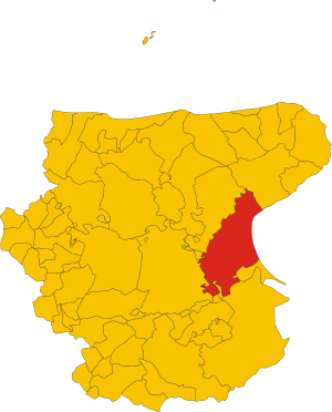
Map of comune of Manfredonia (province of Foggia, region Apulia, Italy).svg
7,356 × 9,121; 171 KB
7,356 × 9,121; 171 KB
1 reference
Manfredonia
0 references
FG
0 references
57,122
56,906
1 January 2018
4 references
Popolazione Residente al 1° Gennaio 2018 (Italian)
16 March 2019
354.54 square kilometre
9 October 2011
5 references
Superficie di Comuni Province e Regioni italiane al 9 ottobre 2011 (Italian)
16 March 2019
Identifiers
83000290714
0 references
2--45757
0 references
E885
0 references


