Scansano (Q290904): Difference between revisions
Jump to navigation
Jump to search
(Changed an Item: Adding this statements since they where added in Wikidata) |
(Changed an Item: Adding this statements since they where added in Wikidata) |
||||||||||||||
| Property / GeoNames ID | |||||||||||||||
| Property / GeoNames ID: 6536862 / rank | |||||||||||||||
Normal rank | |||||||||||||||
| Property / GeoNames ID: 6536862 / reference | |||||||||||||||
| Property / GND ID | |||||||||||||||
| Property / GND ID: 4342557-4 / rank | |||||||||||||||
Normal rank | |||||||||||||||
| Property / GND ID: 4342557-4 / reference | |||||||||||||||
| Property / category for people born here | |||||||||||||||
| Property / category for people born here: Q2608465 / rank | |||||||||||||||
Normal rank | |||||||||||||||
| Property / category for people born here: Q2608465 / reference | |||||||||||||||
| Property / category for people who died here | |||||||||||||||
| Property / category for people who died here: Category:Deaths in Scansano / rank | |||||||||||||||
Normal rank | |||||||||||||||
| Property / category for people who died here: Category:Deaths in Scansano / reference | |||||||||||||||
| Property / topic's main category | |||||||||||||||
| Property / topic's main category: Category:Scansano / rank | |||||||||||||||
Normal rank | |||||||||||||||
| Property / topic's main category: Category:Scansano / reference | |||||||||||||||
| Property / official website | |||||||||||||||
| Property / official website: http://www.comune.scansano.gr.it / rank | |||||||||||||||
Normal rank | |||||||||||||||
| Property / official website: http://www.comune.scansano.gr.it / reference | |||||||||||||||
| Property / VIAF ID | |||||||||||||||
| Property / VIAF ID: 132299576 / rank | |||||||||||||||
Normal rank | |||||||||||||||
| Property / VIAF ID: 132299576 / reference | |||||||||||||||
| Property / VIAF ID: 132299576 / reference | |||||||||||||||
retrieved: 3 August 2015
| |||||||||||||||
| Property / elevation above sea level | |||||||||||||||
500±1 metre
| |||||||||||||||
| Property / elevation above sea level: 500±1 metre / rank | |||||||||||||||
Normal rank | |||||||||||||||
| Property / elevation above sea level: 500±1 metre / reference | |||||||||||||||
| Property / licence plate code | |||||||||||||||
GR | |||||||||||||||
| Property / licence plate code: GR / rank | |||||||||||||||
Normal rank | |||||||||||||||
| Property / coordinates of northernmost point | |||||||||||||||
42°48'23.911"N, 11°21'31.914"E
| |||||||||||||||
| Property / coordinates of northernmost point: 42°48'23.911"N, 11°21'31.914"E / rank | |||||||||||||||
Normal rank | |||||||||||||||
| Property / coordinates of northernmost point: 42°48'23.911"N, 11°21'31.914"E / reference | |||||||||||||||
| Property / coordinates of southernmost point | |||||||||||||||
42°35'10.914"N, 11°23'44.740"E
| |||||||||||||||
| Property / coordinates of southernmost point: 42°35'10.914"N, 11°23'44.740"E / rank | |||||||||||||||
Normal rank | |||||||||||||||
| Property / coordinates of southernmost point: 42°35'10.914"N, 11°23'44.740"E / reference | |||||||||||||||
| Property / coordinates of easternmost point | |||||||||||||||
42°40'33.276"N, 11°27'39.996"E
| |||||||||||||||
| Property / coordinates of easternmost point: 42°40'33.276"N, 11°27'39.996"E / rank | |||||||||||||||
Normal rank | |||||||||||||||
| Property / coordinates of easternmost point: 42°40'33.276"N, 11°27'39.996"E / reference | |||||||||||||||
| Property / coordinates of westernmost point | |||||||||||||||
42°47'32.716"N, 11°11'35.509"E
| |||||||||||||||
| Property / coordinates of westernmost point: 42°47'32.716"N, 11°11'35.509"E / rank | |||||||||||||||
Normal rank | |||||||||||||||
| Property / coordinates of westernmost point: 42°47'32.716"N, 11°11'35.509"E / reference | |||||||||||||||
| Property / OSM relation ID | |||||||||||||||
| Property / OSM relation ID: 42131 / rank | |||||||||||||||
Normal rank | |||||||||||||||
| Property / UN/LOCODE | |||||||||||||||
| Property / UN/LOCODE: ITXSA / rank | |||||||||||||||
Normal rank | |||||||||||||||
| Property / contains administrative territorial entity | |||||||||||||||
| Property / contains administrative territorial entity: Baccinello / rank | |||||||||||||||
Normal rank | |||||||||||||||
| Property / contains administrative territorial entity | |||||||||||||||
| Property / contains administrative territorial entity: Preselle / rank | |||||||||||||||
Normal rank | |||||||||||||||
| Property / contains administrative territorial entity | |||||||||||||||
| Property / contains administrative territorial entity: Pomonte / rank | |||||||||||||||
Normal rank | |||||||||||||||
| Property / contains administrative territorial entity | |||||||||||||||
| Property / contains administrative territorial entity: Polveraia / rank | |||||||||||||||
Normal rank | |||||||||||||||
| Property / contains administrative territorial entity | |||||||||||||||
| Property / contains administrative territorial entity: Montorgiali / rank | |||||||||||||||
Normal rank | |||||||||||||||
Revision as of 01:11, 6 August 2020
Italian comune
| Language | Label | Description | Also known as |
|---|---|---|---|
| English | Scansano |
Italian comune |
Statements

58054
0 references
Scansano
0 references
0564
0 references
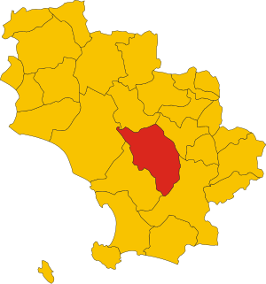
.svg)
Map of comune of Scansano (province of Grosseto, region Tuscany, Italy).svg
3,918 × 4,187; 98 KB
3,918 × 4,187; 98 KB
1 reference


GR
0 references


Identifiers
112590534
0 references