Gimigliano (Q276507): Difference between revisions
Jump to navigation
Jump to search
(Changed an Item: Adding this statements since they where added in Wikidata) |
(Changed an Item: Adding this statements since they where added in Wikidata) |
||||||||||||||
| Property / instance of | |||||||||||||||
| Property / instance of: commune of Italy / rank | |||||||||||||||
Normal rank | |||||||||||||||
| Property / Freebase ID | |||||||||||||||
| Property / Freebase ID: /m/0fh4vr / rank | |||||||||||||||
Normal rank | |||||||||||||||
| Property / Freebase ID: /m/0fh4vr / reference | |||||||||||||||
| Property / Freebase ID: /m/0fh4vr / reference | |||||||||||||||
publication date: 28 October 2013
| |||||||||||||||
| Property / GeoNames ID | |||||||||||||||
| Property / GeoNames ID: 6540042 / rank | |||||||||||||||
Normal rank | |||||||||||||||
| Property / GeoNames ID: 6540042 / reference | |||||||||||||||
| Property / VIAF ID | |||||||||||||||
| Property / VIAF ID: 139521028 / rank | |||||||||||||||
Normal rank | |||||||||||||||
| Property / VIAF ID: 139521028 / reference | |||||||||||||||
| Property / VIAF ID: 139521028 / reference | |||||||||||||||
retrieved: 2 August 2015
| |||||||||||||||
| Property / elevation above sea level | |||||||||||||||
600±1 metre
| |||||||||||||||
| Property / elevation above sea level: 600±1 metre / rank | |||||||||||||||
Normal rank | |||||||||||||||
| Property / elevation above sea level: 600±1 metre / reference | |||||||||||||||
| Property / official website | |||||||||||||||
| Property / official website: http://gimigliano.asmenet.it / rank | |||||||||||||||
Normal rank | |||||||||||||||
| Property / official website: http://gimigliano.asmenet.it / reference | |||||||||||||||
| Property / topic's main category | |||||||||||||||
| Property / topic's main category: Category:Gimigliano / rank | |||||||||||||||
Normal rank | |||||||||||||||
| Property / Commons category | |||||||||||||||
Gimigliano | |||||||||||||||
| Property / Commons category: Gimigliano / rank | |||||||||||||||
Normal rank | |||||||||||||||
| Property / GND ID | |||||||||||||||
| Property / GND ID: 4625661-1 / rank | |||||||||||||||
Normal rank | |||||||||||||||
| Property / GND ID: 4625661-1 / reference | |||||||||||||||
| Property / Library of Congress authority ID | |||||||||||||||
| Property / Library of Congress authority ID: n00146212 / rank | |||||||||||||||
Normal rank | |||||||||||||||
| Property / Library of Congress authority ID: n00146212 / reference | |||||||||||||||
| Property / licence plate code | |||||||||||||||
CZ | |||||||||||||||
| Property / licence plate code: CZ / rank | |||||||||||||||
Normal rank | |||||||||||||||
| Property / OSM relation ID | |||||||||||||||
| Property / OSM relation ID: 39751 / rank | |||||||||||||||
Normal rank | |||||||||||||||
| Property / coordinates of northernmost point | |||||||||||||||
39°2'5.111"N, 16°26'35.678"E
| |||||||||||||||
| Property / coordinates of northernmost point: 39°2'5.111"N, 16°26'35.678"E / rank | |||||||||||||||
Normal rank | |||||||||||||||
| Property / coordinates of northernmost point: 39°2'5.111"N, 16°26'35.678"E / reference | |||||||||||||||
| Property / coordinates of southernmost point | |||||||||||||||
38°56'37.378"N, 16°34'24.715"E
| |||||||||||||||
| Property / coordinates of southernmost point: 38°56'37.378"N, 16°34'24.715"E / rank | |||||||||||||||
Normal rank | |||||||||||||||
| Property / coordinates of southernmost point: 38°56'37.378"N, 16°34'24.715"E / reference | |||||||||||||||
| Property / coordinates of easternmost point | |||||||||||||||
38°57'21.776"N, 16°34'51.344"E
| |||||||||||||||
| Property / coordinates of easternmost point: 38°57'21.776"N, 16°34'51.344"E / rank | |||||||||||||||
Normal rank | |||||||||||||||
| Property / coordinates of easternmost point: 38°57'21.776"N, 16°34'51.344"E / reference | |||||||||||||||
| Property / coordinates of westernmost point | |||||||||||||||
39°1'59.628"N, 16°25'53.393"E
| |||||||||||||||
| Property / coordinates of westernmost point: 39°1'59.628"N, 16°25'53.393"E / rank | |||||||||||||||
Normal rank | |||||||||||||||
| Property / coordinates of westernmost point: 39°1'59.628"N, 16°25'53.393"E / reference | |||||||||||||||
| Property / image | |||||||||||||||
| Property / image: Panorama gimigliano.jpg / rank | |||||||||||||||
Normal rank | |||||||||||||||
| Property / image: Panorama gimigliano.jpg / reference | |||||||||||||||
| Property / capital | |||||||||||||||
| Property / capital: Gimigliano / rank | |||||||||||||||
Normal rank | |||||||||||||||
| Property / area | |||||||||||||||
33.55 square kilometre
| |||||||||||||||
| Property / area: 33.55 square kilometre / rank | |||||||||||||||
Normal rank | |||||||||||||||
| Property / area: 33.55 square kilometre / qualifier | |||||||||||||||
point in time: 9 October 2011
| |||||||||||||||
| Property / area: 33.55 square kilometre / reference | |||||||||||||||
| Property / area: 33.55 square kilometre / reference | |||||||||||||||
| Property / area: 33.55 square kilometre / reference | |||||||||||||||
title: Superficie di Comuni Province e Regioni italiane al 9 ottobre 2011 (Italian) | |||||||||||||||
| Property / area: 33.55 square kilometre / reference | |||||||||||||||
retrieved: 16 March 2019
| |||||||||||||||
| Property / area: 33.55 square kilometre / reference | |||||||||||||||
| Property / population | |||||||||||||||
3,341
| |||||||||||||||
| Property / population: 3,341 / rank | |||||||||||||||
Normal rank | |||||||||||||||
| Property / population: 3,341 / qualifier | |||||||||||||||
point in time: 1 January 2017
| |||||||||||||||
| Property / population: 3,341 / qualifier | |||||||||||||||
| Property / population: 3,341 / reference | |||||||||||||||
Revision as of 10:50, 29 July 2020
Italian comune
| Language | Label | Description | Also known as |
|---|---|---|---|
| English | Gimigliano |
Italian comune |
Statements

.svg)
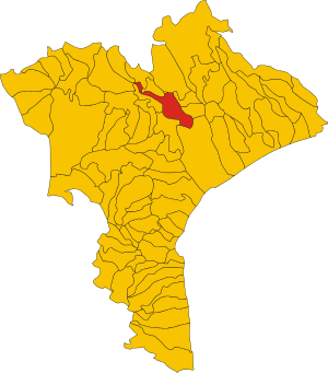
Map of comune of Gimigliano (province of Catanzaro, region Calabria, Italy).svg
3,004 × 3,415; 154 KB
3,004 × 3,415; 154 KB
0 references
Gimigliano
0 references
CZ
0 references


33.55 square kilometre
9 October 2011
5 references
Superficie di Comuni Province e Regioni italiane al 9 ottobre 2011 (Italian)
16 March 2019
3,341
1 January 2017
1 reference
Identifiers
296900798
0 references