Arrondissement of Roeselare (Q2572228): Difference between revisions
Jump to navigation
Jump to search
(Created a new Item: Importing entity Q91439 from wikidata) |
(Changed an Item: Adding this statements since they where added in Wikidata) |
||||||||||||||
| Property / country | |||||||||||||||
| Property / country: Belgium / rank | |||||||||||||||
Normal rank | |||||||||||||||
| Property / country: Belgium / reference | |||||||||||||||
| Property / coordinate location | |||||||||||||||
50°56'48.01"N, 3°7'23.99"E
| |||||||||||||||
| Property / coordinate location: 50°56'48.01"N, 3°7'23.99"E / rank | |||||||||||||||
Normal rank | |||||||||||||||
| Property / coordinate location: 50°56'48.01"N, 3°7'23.99"E / reference | |||||||||||||||
| Property / located in the administrative territorial entity | |||||||||||||||
| Property / located in the administrative territorial entity: West Flanders / rank | |||||||||||||||
Normal rank | |||||||||||||||
| Property / NUTS code | |||||||||||||||
| Property / NUTS code: BE256 / rank | |||||||||||||||
Normal rank | |||||||||||||||
| Property / Freebase ID | |||||||||||||||
| Property / Freebase ID: /m/02pyjd6 / rank | |||||||||||||||
Normal rank | |||||||||||||||
| Property / Freebase ID: /m/02pyjd6 / reference | |||||||||||||||
| Property / Freebase ID: /m/02pyjd6 / reference | |||||||||||||||
publication date: 28 October 2013
| |||||||||||||||
| Property / GeoNames ID | |||||||||||||||
| Property / GeoNames ID: 2787891 / rank | |||||||||||||||
Normal rank | |||||||||||||||
| Property / GeoNames ID: 2787891 / reference | |||||||||||||||
| Property / GeoNames ID | |||||||||||||||
| Property / GeoNames ID: 2787888 / rank | |||||||||||||||
Normal rank | |||||||||||||||
| Property / GeoNames ID: 2787888 / reference | |||||||||||||||
| Property / instance of | |||||||||||||||
| Property / instance of: administrative arrondissement of Belgium / rank | |||||||||||||||
Normal rank | |||||||||||||||
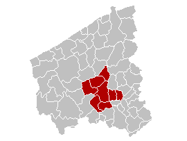
| Property / locator map image | |||||||||||||||
| Property / locator map image: Arrondissement Roeselare Belgium Map.png / rank | |||||||||||||||
Normal rank | |||||||||||||||
| Property / contains administrative territorial entity | |||||||||||||||
| Property / contains administrative territorial entity: Hooglede / rank | |||||||||||||||
Normal rank | |||||||||||||||
| Property / contains administrative territorial entity | |||||||||||||||
| Property / contains administrative territorial entity: Ingelmunster / rank | |||||||||||||||
Normal rank | |||||||||||||||
| Property / contains administrative territorial entity | |||||||||||||||
| Property / contains administrative territorial entity: Izegem / rank | |||||||||||||||
Normal rank | |||||||||||||||
| Property / contains administrative territorial entity | |||||||||||||||
| Property / contains administrative territorial entity: Ledegem / rank | |||||||||||||||
Normal rank | |||||||||||||||
| Property / contains administrative territorial entity | |||||||||||||||
| Property / contains administrative territorial entity: Lichtervelde / rank | |||||||||||||||
Normal rank | |||||||||||||||
| Property / contains administrative territorial entity | |||||||||||||||
| Property / contains administrative territorial entity: Moorslede / rank | |||||||||||||||
Normal rank | |||||||||||||||
| Property / contains administrative territorial entity | |||||||||||||||
| Property / contains administrative territorial entity: Roeselare / rank | |||||||||||||||
Normal rank | |||||||||||||||
| Property / contains administrative territorial entity | |||||||||||||||
| Property / contains administrative territorial entity: Staden / rank | |||||||||||||||
Normal rank | |||||||||||||||
| Property / elevation above sea level | |||||||||||||||
22 metre
| |||||||||||||||
| Property / elevation above sea level: 22 metre / rank | |||||||||||||||
Normal rank | |||||||||||||||
| Property / elevation above sea level: 22 metre / reference | |||||||||||||||
| Property / elevation above sea level: 22 metre / reference | |||||||||||||||
retrieved: 9 July 2017
| |||||||||||||||
| Property / image | |||||||||||||||
| Property / image: Grotemarktroeselare1.jpg / rank | |||||||||||||||
Normal rank | |||||||||||||||
| Property / image: Grotemarktroeselare1.jpg / reference | |||||||||||||||
| Property / image: Grotemarktroeselare1.jpg / reference | |||||||||||||||
| Property / area | |||||||||||||||
271.54 square kilometre
| |||||||||||||||
| Property / area: 271.54 square kilometre / rank | |||||||||||||||
Normal rank | |||||||||||||||
| Property / area: 271.54 square kilometre / reference | |||||||||||||||
| Property / area: 271.54 square kilometre / reference | |||||||||||||||
Revision as of 19:51, 3 July 2020
1 of 43 administrative arrondissements of Belgium
| Language | Label | Description | Also known as |
|---|---|---|---|
| English | Arrondissement of Roeselare |
1 of 43 administrative arrondissements of Belgium |
Statements
271.54 square kilometre


