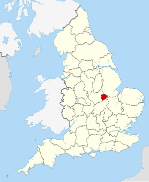
Rutland (Q2554917): Difference between revisions
Jump to navigation
Jump to search
(Changed an Item: Adding this statements since they where added in Wikidata) |
(Changed an Item: Adding this statements since they where added in Wikidata) |
||||||||||||||
| Property / official website | |||||||||||||||
| Property / official website: https://www.rutland.gov.uk/ / rank | |||||||||||||||
Normal rank | |||||||||||||||
| Property / official website: https://www.rutland.gov.uk/ / reference | |||||||||||||||
| Property / category for people born here | |||||||||||||||
| Property / category for people born here: Category:Births in Rutland / rank | |||||||||||||||
Normal rank | |||||||||||||||
| Property / page banner | |||||||||||||||
| Property / page banner: WV banner Rutland Oakham Park in the winter.jpg / rank | |||||||||||||||
Normal rank | |||||||||||||||
| Property / Vision of Britain place ID | |||||||||||||||
| Property / Vision of Britain place ID: 17258 / rank | |||||||||||||||
Normal rank | |||||||||||||||
| Property / Vision of Britain place ID: 17258 / qualifier | |||||||||||||||
named as: Rutland, England | |||||||||||||||
| Property / Vision of Britain place ID: 17258 / reference | |||||||||||||||
retrieved: 1 March 2017
| |||||||||||||||
| Property / GSS code (2011) | |||||||||||||||
| Property / GSS code (2011): E06000017 / rank | |||||||||||||||
Normal rank | |||||||||||||||
| Property / GSS code (2011): E06000017 / reference | |||||||||||||||
retrieved: 14 March 2017
| |||||||||||||||
| Property / area | |||||||||||||||
381.8313 square kilometre
| |||||||||||||||
| Property / area: 381.8313 square kilometre / rank | |||||||||||||||
Normal rank | |||||||||||||||
| Property / area: 381.8313 square kilometre / qualifier | |||||||||||||||
point in time: 2016
| |||||||||||||||
| Property / area: 381.8313 square kilometre / reference | |||||||||||||||
| Property / population | |||||||||||||||
38,000
| |||||||||||||||
| Property / population: 38,000 / rank | |||||||||||||||
Normal rank | |||||||||||||||
| Property / population: 38,000 / qualifier | |||||||||||||||
point in time: 2015
| |||||||||||||||
| Property / population | |||||||||||||||
39,697
| |||||||||||||||
| Property / population: 39,697 / rank | |||||||||||||||
Preferred rank | |||||||||||||||
| Property / population: 39,697 / qualifier | |||||||||||||||
point in time: 2018
| |||||||||||||||
| Property / population: 39,697 / qualifier | |||||||||||||||
| Property / population: 39,697 / reference | |||||||||||||||
| Property / NUTS code | |||||||||||||||
| Property / NUTS code: UKF22 / rank | |||||||||||||||
Normal rank | |||||||||||||||
| Property / TOID | |||||||||||||||
7000000000037528 | |||||||||||||||
| Property / TOID: 7000000000037528 / rank | |||||||||||||||
Normal rank | |||||||||||||||
| Property / YSO ID | |||||||||||||||
| Property / YSO ID: 160699 / rank | |||||||||||||||
Normal rank | |||||||||||||||
| Property / archINFORM location ID | |||||||||||||||
| Property / archINFORM location ID: 16551 / rank | |||||||||||||||
Normal rank | |||||||||||||||
| Property / archINFORM location ID: 16551 / reference | |||||||||||||||
| Property / archINFORM location ID: 16551 / reference | |||||||||||||||
| Property / archINFORM location ID: 16551 / reference | |||||||||||||||
retrieved: 5 August 2018
| |||||||||||||||
| Property / geoshape | |||||||||||||||
| Property / geoshape: Data:Rutland.map / rank | |||||||||||||||
Normal rank | |||||||||||||||
| Property / Library of Congress authority ID | |||||||||||||||
| Property / Library of Congress authority ID: n83135435 / rank | |||||||||||||||
Normal rank | |||||||||||||||
| Property / Library of Congress authority ID: n83135435 / reference | |||||||||||||||
| Property / Library of Congress authority ID: n83135435 / reference | |||||||||||||||
retrieved: 6 March 2019
| |||||||||||||||
| Property / Who's on First ID | |||||||||||||||
| Property / Who's on First ID: 85684297 / rank | |||||||||||||||
Normal rank | |||||||||||||||
| Property / Gran Enciclopèdia Catalana ID | |||||||||||||||
| Property / Gran Enciclopèdia Catalana ID: 0057426 / rank | |||||||||||||||
Normal rank | |||||||||||||||
| Property / described by source | |||||||||||||||
| Property / described by source: Brockhaus and Efron Encyclopedic Dictionary (Russian Transl.) / rank | |||||||||||||||
Normal rank | |||||||||||||||
| Property / described by source: Brockhaus and Efron Encyclopedic Dictionary (Russian Transl.) / qualifier | |||||||||||||||
| Property / described by source | |||||||||||||||
| Property / described by source: Ottův slovník naučný / rank | |||||||||||||||
Normal rank | |||||||||||||||
| Property / described by source: Ottův slovník naučný / qualifier | |||||||||||||||
| Property / described by source | |||||||||||||||
| Property / described by source: Granat Encyclopedic Dictionary / rank | |||||||||||||||
Normal rank | |||||||||||||||
| Property / described by source: Granat Encyclopedic Dictionary / qualifier | |||||||||||||||
| Property / legislative body | |||||||||||||||
| Property / legislative body: Rutland County Council / rank | |||||||||||||||
Normal rank | |||||||||||||||
Revision as of 07:20, 3 July 2020
district in the East Midlands, United Kingdom
| Language | Label | Description | Also known as |
|---|---|---|---|
| English | Rutland |
district in the East Midlands, United Kingdom |
Statements
Rutland
0 references
381.8313 square kilometre
2016
Identifiers
UKL4
5 references
30 December 2013
List of FIPS region codes (S-U) (English)
7000000000037528
0 references
3 references

