London Borough of Enfield (Q2549622): Difference between revisions
Jump to navigation
Jump to search
(Changed an Item: Sitelinks in wikidata changed) |
(Changed an Item: Adding this statements since they where added in Wikidata) |
||||||||||||||
| Property / Commons category | |||||||||||||||
London Borough of Enfield | |||||||||||||||
| Property / Commons category: London Borough of Enfield / rank | |||||||||||||||
Normal rank | |||||||||||||||
| Property / Commons category: London Borough of Enfield / reference | |||||||||||||||
| Property / country | |||||||||||||||
| Property / country: United Kingdom / rank | |||||||||||||||
Normal rank | |||||||||||||||
| Property / country: United Kingdom / reference | |||||||||||||||
| Property / located in the administrative territorial entity | |||||||||||||||
| Property / located in the administrative territorial entity: Greater London / rank | |||||||||||||||
Normal rank | |||||||||||||||
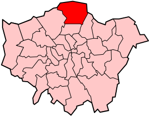
| Property / locator map image | |||||||||||||||
| Property / locator map image: LondonEnfield.svg / rank | |||||||||||||||
Normal rank | |||||||||||||||
| Property / local dialing code | |||||||||||||||
01992 | |||||||||||||||
| Property / local dialing code: 01992 / rank | |||||||||||||||
Normal rank | |||||||||||||||
| Property / local dialing code | |||||||||||||||
020 | |||||||||||||||
| Property / local dialing code: 020 / rank | |||||||||||||||
Normal rank | |||||||||||||||
| Property / shares border with | |||||||||||||||
| Property / shares border with: London Borough of Barnet / rank | |||||||||||||||
Normal rank | |||||||||||||||
| Property / shares border with: London Borough of Barnet / qualifier | |||||||||||||||
start time: 1 April 1965
| |||||||||||||||
| Property / shares border with | |||||||||||||||
| Property / shares border with: London Borough of Haringey / rank | |||||||||||||||
Normal rank | |||||||||||||||
| Property / shares border with: London Borough of Haringey / qualifier | |||||||||||||||
start time: 1 April 1965
| |||||||||||||||
| Property / shares border with | |||||||||||||||
| Property / shares border with: London Borough of Waltham Forest / rank | |||||||||||||||
Normal rank | |||||||||||||||
| Property / shares border with: London Borough of Waltham Forest / qualifier | |||||||||||||||
start time: 1 April 1965
| |||||||||||||||
| Property / shares border with | |||||||||||||||
| Property / shares border with: Broxbourne / rank | |||||||||||||||
Normal rank | |||||||||||||||
| Property / shares border with: Broxbourne / qualifier | |||||||||||||||
start time: 1 April 1974
| |||||||||||||||
| Property / shares border with | |||||||||||||||
| Property / shares border with: Epping Forest / rank | |||||||||||||||
Normal rank | |||||||||||||||
| Property / shares border with: Epping Forest / qualifier | |||||||||||||||
start time: 1 April 1974
| |||||||||||||||
| Property / shares border with | |||||||||||||||
| Property / shares border with: Waltham Holy Cross Urban District / rank | |||||||||||||||
Normal rank | |||||||||||||||
| Property / shares border with: Waltham Holy Cross Urban District / qualifier | |||||||||||||||
start time: 1 April 1965
| |||||||||||||||
| Property / shares border with: Waltham Holy Cross Urban District / qualifier | |||||||||||||||
end time: 31 March 1974
| |||||||||||||||
| Property / shares border with | |||||||||||||||
| Property / shares border with: Hertsmere / rank | |||||||||||||||
Normal rank | |||||||||||||||
| Property / shares border with: Hertsmere / qualifier | |||||||||||||||
start time: 1 April 1974
| |||||||||||||||
| Property / shares border with | |||||||||||||||
| Property / shares border with: Potters Bar Urban District / rank | |||||||||||||||
Normal rank | |||||||||||||||
| Property / shares border with: Potters Bar Urban District / qualifier | |||||||||||||||
start time: 1 April 1965
| |||||||||||||||
| Property / shares border with: Potters Bar Urban District / qualifier | |||||||||||||||
end time: 31 March 1974
| |||||||||||||||
| Property / ISO 3166-2 code | |||||||||||||||
GB-ENF | |||||||||||||||
| Property / ISO 3166-2 code: GB-ENF / rank | |||||||||||||||
Normal rank | |||||||||||||||
| Property / ISO 3166-2 code: GB-ENF / reference | |||||||||||||||
| Property / coordinate location | |||||||||||||||
51°39'17"N, 0°4'47"W
| |||||||||||||||
| Property / coordinate location: 51°39'17"N, 0°4'47"W / rank | |||||||||||||||
Normal rank | |||||||||||||||
| Property / topic's main category | |||||||||||||||
| Property / topic's main category: Category:London Borough of Enfield / rank | |||||||||||||||
Normal rank | |||||||||||||||
| Property / instance of | |||||||||||||||
| Property / instance of: London Region borough / rank | |||||||||||||||
Normal rank | |||||||||||||||
| Property / Freebase ID | |||||||||||||||
| Property / Freebase ID: /m/0nccd / rank | |||||||||||||||
Normal rank | |||||||||||||||
| Property / Freebase ID: /m/0nccd / reference | |||||||||||||||
| Property / Freebase ID: /m/0nccd / reference | |||||||||||||||
publication date: 28 October 2013
| |||||||||||||||
| Property / FIPS 10-4 (countries and regions) | |||||||||||||||
UKE3 | |||||||||||||||
| Property / FIPS 10-4 (countries and regions): UKE3 / rank | |||||||||||||||
Normal rank | |||||||||||||||
| Property / FIPS 10-4 (countries and regions): UKE3 / reference | |||||||||||||||
| Property / FIPS 10-4 (countries and regions): UKE3 / reference | |||||||||||||||
| Property / FIPS 10-4 (countries and regions): UKE3 / reference | |||||||||||||||
| Property / FIPS 10-4 (countries and regions): UKE3 / reference | |||||||||||||||
retrieved: 30 December 2013
| |||||||||||||||
| Property / FIPS 10-4 (countries and regions): UKE3 / reference | |||||||||||||||
title: List of FIPS region codes (S-U) (English) | |||||||||||||||
Revision as of 20:42, 2 July 2020
London borough in north London, England
- Enfield
- Borough of Enfield
| Language | Label | Description | Also known as |
|---|---|---|---|
| English | London Borough of Enfield |
London borough in north London, England |
|
Statements
01992
0 references
020
0 references
Identifiers
UKE3
5 references
30 December 2013
List of FIPS region codes (S-U) (English)

