Innichen (Q297102): Difference between revisions
Jump to navigation
Jump to search
(Removed claim: country (P32): Italy (Q15), Removing this statements since they changed in Wikidata) |
(Changed an Item: Adding this statements since they where added in Wikidata) |
||||||||||
| Property / Dewey Decimal Classification | |||||||||||
2--45383 | |||||||||||
| Property / Dewey Decimal Classification: 2--45383 / rank | |||||||||||
Deprecated rank | |||||||||||
| Property / topic's main category | |||||||||||
| Property / topic's main category: Category:Innichen / rank | |||||||||||
Normal rank | |||||||||||
| Property / Commons category | |||||||||||
Innichen | |||||||||||
| Property / Commons category: Innichen / rank | |||||||||||
Normal rank | |||||||||||
| Property / postal code | |||||||||||
39038 | |||||||||||
| Property / postal code: 39038 / rank | |||||||||||
Normal rank | |||||||||||
| Property / shares border with | |||||||||||
| Property / shares border with: Dobbiaco / rank | |||||||||||
Normal rank | |||||||||||
| Property / shares border with | |||||||||||
| Property / shares border with: Sexten / rank | |||||||||||
Normal rank | |||||||||||
| Property / shares border with: Sexten / reference | |||||||||||
| Property / shares border with | |||||||||||
| Property / shares border with: Innervillgraten / rank | |||||||||||
Normal rank | |||||||||||
| Property / shares border with: Innervillgraten / reference | |||||||||||
| Property / shares border with | |||||||||||
| Property / shares border with: Sillian / rank | |||||||||||
Normal rank | |||||||||||
| Property / shares border with: Sillian / reference | |||||||||||
| Property / local dialing code | |||||||||||
0474 | |||||||||||
| Property / local dialing code: 0474 / rank | |||||||||||
Normal rank | |||||||||||
| Property / local dialing code: 0474 / reference | |||||||||||
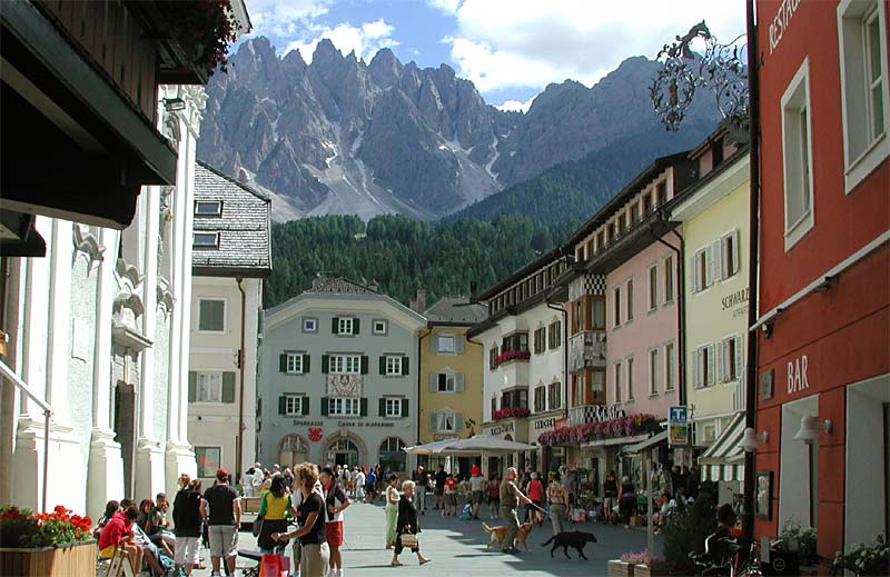
| Property / image | |||||||||||
| Property / image: St. Michaelsplatz Innichen.jpg / rank | |||||||||||
Normal rank | |||||||||||
| Property / image | |||||||||||
| Property / image: Innichen.jpg / rank | |||||||||||
Normal rank | |||||||||||
| Property / image | |||||||||||
| Property / image: Innichen Fußgängerzone 2013.JPG / rank | |||||||||||
Preferred rank | |||||||||||
| Property / located in time zone | |||||||||||
| Property / located in time zone: UTC+01:00 / rank | |||||||||||
Normal rank | |||||||||||
| Property / located in time zone: UTC+01:00 / qualifier | |||||||||||
| Property / located in time zone: UTC+01:00 / reference | |||||||||||
| Property / located in time zone | |||||||||||
| Property / located in time zone: UTC+02:00 / rank | |||||||||||
Normal rank | |||||||||||
| Property / located in time zone: UTC+02:00 / qualifier | |||||||||||
| Property / locator map image | |||||||||||
| Property / locator map image: Map of comune of San Candido (autonomous province of Bolzano, region Trentino-Alto Adige-Südtirol, Italy).svg / rank | |||||||||||
Normal rank | |||||||||||
| Property / locator map image: Map of comune of San Candido (autonomous province of Bolzano, region Trentino-Alto Adige-Südtirol, Italy).svg / reference | |||||||||||
| Property / ISTAT ID | |||||||||||
021077 | |||||||||||
| Property / ISTAT ID: 021077 / rank | |||||||||||
Normal rank | |||||||||||
| Property / ISTAT ID: 021077 / reference | |||||||||||
| Property / coordinate location | |||||||||||
46°44'0"N, 12°17'0"E
| |||||||||||
| Property / coordinate location: 46°44'0"N, 12°17'0"E / rank | |||||||||||
Normal rank | |||||||||||
| Property / coordinate location: 46°44'0"N, 12°17'0"E / reference | |||||||||||
| Property / coordinate location | |||||||||||
46°43'56.64"N, 12°16'42.78"E
| |||||||||||
| Property / coordinate location: 46°43'56.64"N, 12°16'42.78"E / rank | |||||||||||
Preferred rank | |||||||||||
| Property / coordinate location: 46°43'56.64"N, 12°16'42.78"E / reference | |||||||||||
| Property / country | |||||||||||
| Property / country: Italy / rank | |||||||||||
Normal rank | |||||||||||
| Property / country: Italy / reference | |||||||||||
| Property / located in the administrative territorial entity | |||||||||||
| Property / located in the administrative territorial entity: autonomous Province of Bolzano / rank | |||||||||||
Normal rank | |||||||||||
Revision as of 19:14, 5 August 2020
comune in South Tyrol (Italy)
- San Candido
| Language | Label | Description | Also known as |
|---|---|---|---|
| English | Innichen |
comune in South Tyrol (Italy) |
|
Statements
39038
0 references
Innichen
0 references
Identifiers
81006750210
0 references
2--45383
0 references


