London Borough of Lambeth (Q2549693): Difference between revisions
Jump to navigation
Jump to search
(Changed an Item: Adding this statements since they where added in Wikidata) |
(Changed an Item: Adding this statements since they where added in Wikidata) |
||||||||||||||
| Property / category for people who died here | |||||||||||||||
| Property / category for people who died here: Category:Deaths in Lambeth, London / rank | |||||||||||||||
Normal rank | |||||||||||||||
| Property / category for people who died here: Category:Deaths in Lambeth, London / reference | |||||||||||||||
| Property / ISNI | |||||||||||||||
| Property / ISNI: 0000 0001 2359 2633 / rank | |||||||||||||||
Normal rank | |||||||||||||||
| Property / Ringgold ID | |||||||||||||||
| Property / Ringgold ID: 62677 / rank | |||||||||||||||
Normal rank | |||||||||||||||
| Property / Ringgold ID: 62677 / reference | |||||||||||||||
| Property / GSS code (2011) | |||||||||||||||
| Property / GSS code (2011): E09000022 / rank | |||||||||||||||
Normal rank | |||||||||||||||
| Property / GSS code (2011): E09000022 / reference | |||||||||||||||
retrieved: 14 March 2017
| |||||||||||||||
| Property / TOID | |||||||||||||||
7000000000011144 | |||||||||||||||
| Property / TOID: 7000000000011144 / rank | |||||||||||||||
Normal rank | |||||||||||||||
| Property / population | |||||||||||||||
324,400
| |||||||||||||||
| Property / population: 324,400 / rank | |||||||||||||||
Normal rank | |||||||||||||||
| Property / population: 324,400 / qualifier | |||||||||||||||
point in time: 2015
| |||||||||||||||
| Property / population: 324,400 / qualifier | |||||||||||||||
| Property / population: 324,400 / reference | |||||||||||||||
| Property / population | |||||||||||||||
325,917
| |||||||||||||||
| Property / population: 325,917 / rank | |||||||||||||||
Preferred rank | |||||||||||||||
| Property / population: 325,917 / qualifier | |||||||||||||||
point in time: 2018
| |||||||||||||||
| Property / population: 325,917 / qualifier | |||||||||||||||
| Property / population: 325,917 / reference | |||||||||||||||
| Property / located in time zone | |||||||||||||||
| Property / located in time zone: UTC±00:00 / rank | |||||||||||||||
Normal rank | |||||||||||||||
| Property / located in time zone: UTC±00:00 / qualifier | |||||||||||||||
| Property / located in time zone | |||||||||||||||
| Property / located in time zone: UTC+01:00 / rank | |||||||||||||||
Normal rank | |||||||||||||||
| Property / located in time zone: UTC+01:00 / qualifier | |||||||||||||||
| Property / local dialing code | |||||||||||||||
020 | |||||||||||||||
| Property / local dialing code: 020 / rank | |||||||||||||||
Normal rank | |||||||||||||||
| Property / local dialing code: 020 / reference | |||||||||||||||
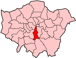
| Property / locator map image | |||||||||||||||
| Property / locator map image: Lambeth in Greater London.svg / rank | |||||||||||||||
Normal rank | |||||||||||||||
| Property / locator map image: Lambeth in Greater London.svg / reference | |||||||||||||||
| Property / area | |||||||||||||||
26.8101 square kilometre
| |||||||||||||||
| Property / area: 26.8101 square kilometre / rank | |||||||||||||||
Normal rank | |||||||||||||||
| Property / area: 26.8101 square kilometre / qualifier | |||||||||||||||
point in time: 2016
| |||||||||||||||
| Property / area: 26.8101 square kilometre / reference | |||||||||||||||
| Property / location map | |||||||||||||||
| Property / location map: LondonLambeth.svg / rank | |||||||||||||||
Normal rank | |||||||||||||||
| Property / location map: LondonLambeth.svg / reference | |||||||||||||||
| Property / category of associated people | |||||||||||||||
| Property / category of associated people: Q2549700 / rank | |||||||||||||||
Normal rank | |||||||||||||||
| Property / TGN ID | |||||||||||||||
| Property / TGN ID: 7018923 / rank | |||||||||||||||
Normal rank | |||||||||||||||
| Property / page banner | |||||||||||||||
| Property / page banner: Brixton Academy banner 2.jpg / rank | |||||||||||||||
Normal rank | |||||||||||||||
| Property / archINFORM location ID | |||||||||||||||
| Property / archINFORM location ID: 42397 / rank | |||||||||||||||
Normal rank | |||||||||||||||
| Property / archINFORM location ID: 42397 / reference | |||||||||||||||
| Property / archINFORM location ID: 42397 / reference | |||||||||||||||
| Property / archINFORM location ID: 42397 / reference | |||||||||||||||
retrieved: 5 August 2018
| |||||||||||||||
| Property / authority | |||||||||||||||
| Property / authority: Lambeth London Borough Council / rank | |||||||||||||||
Normal rank | |||||||||||||||
| Property / legislative body | |||||||||||||||
| Property / legislative body: council of Lambeth London Borough Council / rank | |||||||||||||||
Normal rank | |||||||||||||||
| Property / different from | |||||||||||||||
| Property / different from: Lambeth / rank | |||||||||||||||
Normal rank | |||||||||||||||
Revision as of 20:42, 2 July 2020
London borough in south London, England
- Lambeth
| Language | Label | Description | Also known as |
|---|---|---|---|
| English | London Borough of Lambeth |
London borough in south London, England |
|
Statements
SE
0 references
SW
0 references
London Borough of Lambeth
0 references
324,400
26.8101 square kilometre
2016
Identifiers
UKH1
5 references
30 December 2013
List of FIPS region codes (S-U) (English)
7000000000011144
0 references
3 references


