Marradi (Q262975): Difference between revisions
Jump to navigation
Jump to search
(Created a new Item) |
(Changed an Item: Adding these statements since they where added in Wikidata) |
||||||||||||||
| (24 intermediate revisions by 2 users not shown) | |||||||||||||||
| label / it | label / it | ||||||||||||||
Marradi | |||||||||||||||
| label / de | label / de | ||||||||||||||
Marradi | |||||||||||||||
| label / en | label / en | ||||||||||||||
Marradi | |||||||||||||||
| label / es | label / es | ||||||||||||||
Marradi | |||||||||||||||
| label / fr | label / fr | ||||||||||||||
Marradi | |||||||||||||||
| label / nl | label / nl | ||||||||||||||
Marradi | |||||||||||||||
| label / pl | label / pl | ||||||||||||||
Marradi | |||||||||||||||
| label / pt | label / pt | ||||||||||||||
Marradi | |||||||||||||||
| label / ro | label / ro | ||||||||||||||
Marradi | |||||||||||||||
| label / cs | label / cs | ||||||||||||||
Marradi | |||||||||||||||
| label / bg | label / bg | ||||||||||||||
Маради | |||||||||||||||
| label / hu | label / hu | ||||||||||||||
Marradi | |||||||||||||||
| label / da | label / da | ||||||||||||||
Marradi | |||||||||||||||
| label / tr | label / tr | ||||||||||||||
Marradi | |||||||||||||||
| label / sv | label / sv | ||||||||||||||
Marradi | |||||||||||||||
| label / ga | label / ga | ||||||||||||||
Marradi | |||||||||||||||
| label / el | label / el | ||||||||||||||
Μαρράντι | |||||||||||||||
| description / en | description / en | ||||||||||||||
Italian comune | |||||||||||||||
| description / bg | description / bg | ||||||||||||||
италианска община | |||||||||||||||
| description / cs | description / cs | ||||||||||||||
italská obec | |||||||||||||||
| description / de | description / de | ||||||||||||||
italienische Gemeinde | |||||||||||||||
| description / el | description / el | ||||||||||||||
ιταλικός δήμος στην Μητροπολιτική Πόλη της Φλωρεντίας | |||||||||||||||
| description / es | description / es | ||||||||||||||
municipio italiano | |||||||||||||||
| description / fr | description / fr | ||||||||||||||
commune italienne | |||||||||||||||
| description / hr | description / hr | ||||||||||||||
Talijanske općine | |||||||||||||||
| description / it | description / it | ||||||||||||||
comune italiano | |||||||||||||||
| description / lt | description / lt | ||||||||||||||
komuna Italijoje | |||||||||||||||
| description / nl | description / nl | ||||||||||||||
Italiaanse gemeente | |||||||||||||||
| description / pl | description / pl | ||||||||||||||
włoska gmina | |||||||||||||||
| description / pt | description / pt | ||||||||||||||
comuna italiana | |||||||||||||||
| description / sv | description / sv | ||||||||||||||
kommun i Italien | |||||||||||||||
| description / tr | description / tr | ||||||||||||||
İtalya'nın Komünleri | |||||||||||||||
| description / hu | description / hu | ||||||||||||||
település Olaszországban | |||||||||||||||
| description / ro | description / ro | ||||||||||||||
comună din Italia | |||||||||||||||
| description / fi | description / fi | ||||||||||||||
kunta Italiassa | |||||||||||||||
| Property / country | |||||||||||||||
| Property / country: Italy / rank | |||||||||||||||
| Property / instance of | |||||||||||||||
| Property / instance of: beneficiary / rank | |||||||||||||||
| Property / instance of | |||||||||||||||
| Property / instance of: commune of Italy / rank | |||||||||||||||
Normal rank | |||||||||||||||
| Property / instance of | |||||||||||||||
| Property / instance of: beneficiary / rank | |||||||||||||||
Preferred rank | |||||||||||||||
| Property / instance of | |||||||||||||||
| Property / instance of: public beneficiary / rank | |||||||||||||||
Normal rank | |||||||||||||||
| Property / instance of: public beneficiary / qualifier | |||||||||||||||
| Property / Wikidata QID | |||||||||||||||
| Property / Wikidata QID: Q82759 / rank | |||||||||||||||
Normal rank | |||||||||||||||
| Property / topic's main category | |||||||||||||||
| Property / topic's main category: Category:Marradi / rank | |||||||||||||||
Normal rank | |||||||||||||||
| Property / Commons category | |||||||||||||||
Marradi | |||||||||||||||
| Property / Commons category: Marradi / rank | |||||||||||||||
Normal rank | |||||||||||||||
| Property / located in the administrative territorial entity | |||||||||||||||
| Property / located in the administrative territorial entity: Province of Florence / rank | |||||||||||||||
Normal rank | |||||||||||||||
| Property / located in the administrative territorial entity: Province of Florence / qualifier | |||||||||||||||
end time: 31 December 2014
| |||||||||||||||
| Property / located in the administrative territorial entity: Province of Florence / reference | |||||||||||||||
| Property / located in the administrative territorial entity | |||||||||||||||
| Property / located in the administrative territorial entity: Metropolitan City of Florence / rank | |||||||||||||||
Preferred rank | |||||||||||||||
| Property / located in the administrative territorial entity: Metropolitan City of Florence / qualifier | |||||||||||||||
start time: 1 January 2015
| |||||||||||||||
| Property / located in the administrative territorial entity: Metropolitan City of Florence / qualifier | |||||||||||||||
| Property / postal code | |||||||||||||||
50034 | |||||||||||||||
| Property / postal code: 50034 / rank | |||||||||||||||
Normal rank | |||||||||||||||
| Property / postal code: 50034 / reference | |||||||||||||||
| Property / shares border with | |||||||||||||||
| Property / shares border with: Brisighella / rank | |||||||||||||||
Normal rank | |||||||||||||||
| Property / shares border with | |||||||||||||||
| Property / shares border with: Dicomano / rank | |||||||||||||||
Normal rank | |||||||||||||||
| Property / shares border with | |||||||||||||||
| Property / shares border with: Modigliana / rank | |||||||||||||||
Normal rank | |||||||||||||||
| Property / shares border with: Modigliana / reference | |||||||||||||||
| Property / shares border with | |||||||||||||||
| Property / shares border with: Portico e San Benedetto / rank | |||||||||||||||
Normal rank | |||||||||||||||
| Property / shares border with: Portico e San Benedetto / reference | |||||||||||||||
| Property / shares border with | |||||||||||||||
| Property / shares border with: San Godenzo / rank | |||||||||||||||
Normal rank | |||||||||||||||
| Property / shares border with | |||||||||||||||
| Property / shares border with: Tredozio / rank | |||||||||||||||
Normal rank | |||||||||||||||
| Property / shares border with | |||||||||||||||
| Property / shares border with: Vicchio / rank | |||||||||||||||
Normal rank | |||||||||||||||
| Property / shares border with: Vicchio / reference | |||||||||||||||
| Property / shares border with | |||||||||||||||
| Property / shares border with: Borgo San Lorenzo / rank | |||||||||||||||
Normal rank | |||||||||||||||
| Property / shares border with: Borgo San Lorenzo / reference | |||||||||||||||
| Property / shares border with | |||||||||||||||
| Property / shares border with: Palazzuolo sul Senio / rank | |||||||||||||||
Normal rank | |||||||||||||||
| Property / shares border with: Palazzuolo sul Senio / reference | |||||||||||||||
| Property / local dialing code | |||||||||||||||
055 | |||||||||||||||
| Property / local dialing code: 055 / rank | |||||||||||||||
Normal rank | |||||||||||||||
| Property / local dialing code: 055 / reference | |||||||||||||||
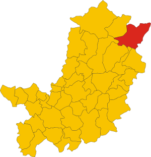
| Property / locator map image | |||||||||||||||
| Property / locator map image: Map of comune of Marradi (province of Florence, region Tuscany, Italy).svg / rank | |||||||||||||||
Normal rank | |||||||||||||||
| Property / locator map image: Map of comune of Marradi (province of Florence, region Tuscany, Italy).svg / reference | |||||||||||||||
| Property / located in time zone | |||||||||||||||
| Property / located in time zone: UTC+01:00 / rank | |||||||||||||||
Normal rank | |||||||||||||||
| Property / located in time zone: UTC+01:00 / qualifier | |||||||||||||||
| Property / located in time zone: UTC+01:00 / reference | |||||||||||||||
| Property / located in time zone | |||||||||||||||
| Property / located in time zone: UTC+02:00 / rank | |||||||||||||||
Normal rank | |||||||||||||||
| Property / located in time zone: UTC+02:00 / qualifier | |||||||||||||||
| Property / ISTAT ID | |||||||||||||||
048026 | |||||||||||||||
| Property / ISTAT ID: 048026 / rank | |||||||||||||||
Normal rank | |||||||||||||||
| Property / ISTAT ID: 048026 / reference | |||||||||||||||
| Property / coordinate location | |||||||||||||||
44°5'0"N, 11°37'0"E
| |||||||||||||||
| Property / coordinate location: 44°5'0"N, 11°37'0"E / rank | |||||||||||||||
Normal rank | |||||||||||||||
| Property / coordinate location: 44°5'0"N, 11°37'0"E / reference | |||||||||||||||
| Property / country | |||||||||||||||
| Property / country: Italy / rank | |||||||||||||||
Normal rank | |||||||||||||||
| Property / country: Italy / reference | |||||||||||||||
| Property / Italian cadastre code | |||||||||||||||
E971 | |||||||||||||||
| Property / Italian cadastre code: E971 / rank | |||||||||||||||
Normal rank | |||||||||||||||
| Property / Italian cadastre code: E971 / reference | |||||||||||||||
| Property / official website | |||||||||||||||
| Property / official website: http://www.comune.marradi.fi.it/ / rank | |||||||||||||||
Normal rank | |||||||||||||||
| Property / official website: http://www.comune.marradi.fi.it/ / reference | |||||||||||||||
| Property / Freebase ID | |||||||||||||||
| Property / Freebase ID: /m/0glcm1 / rank | |||||||||||||||
Normal rank | |||||||||||||||
| Property / Freebase ID: /m/0glcm1 / reference | |||||||||||||||
| Property / Freebase ID: /m/0glcm1 / reference | |||||||||||||||
publication date: 28 October 2013
| |||||||||||||||
| Property / GeoNames ID | |||||||||||||||
| Property / GeoNames ID: 6538561 / rank | |||||||||||||||
Normal rank | |||||||||||||||
| Property / GeoNames ID: 6538561 / reference | |||||||||||||||
| Property / category for people born here | |||||||||||||||
| Property / category for people born here: Q2578760 / rank | |||||||||||||||
Normal rank | |||||||||||||||
| Property / category for people born here: Q2578760 / reference | |||||||||||||||
| Property / category for people who died here | |||||||||||||||
| Property / category for people who died here: Category:Deaths in Marradi / rank | |||||||||||||||
Normal rank | |||||||||||||||
| Property / category for people who died here: Category:Deaths in Marradi / reference | |||||||||||||||
| Property / image | |||||||||||||||
| Property / image: Marradi - view of Marradi 4.JPG / rank | |||||||||||||||
Normal rank | |||||||||||||||
| Property / VIAF ID | |||||||||||||||
| Property / VIAF ID: 149113999 / rank | |||||||||||||||
Normal rank | |||||||||||||||
| Property / VIAF ID: 149113999 / reference | |||||||||||||||
| Property / VIAF ID: 149113999 / reference | |||||||||||||||
retrieved: 2 August 2015
| |||||||||||||||
| Property / elevation above sea level | |||||||||||||||
328±1 metre
| |||||||||||||||
| Property / elevation above sea level: 328±1 metre / rank | |||||||||||||||
Normal rank | |||||||||||||||
| Property / elevation above sea level: 328±1 metre / reference | |||||||||||||||
| Property / category of associated people | |||||||||||||||
| Property / category of associated people: Category:People from Marradi / rank | |||||||||||||||
Normal rank | |||||||||||||||
| Property / licence plate code | |||||||||||||||
FI | |||||||||||||||
| Property / licence plate code: FI / rank | |||||||||||||||
Normal rank | |||||||||||||||
| Property / WOEID | |||||||||||||||
| Property / WOEID: 717965 / rank | |||||||||||||||
Normal rank | |||||||||||||||
| Property / WOEID: 717965 / reference | |||||||||||||||
| Property / population | |||||||||||||||
3,192
| |||||||||||||||
| Property / population: 3,192 / rank | |||||||||||||||
Normal rank | |||||||||||||||
| Property / population: 3,192 / qualifier | |||||||||||||||
point in time: 31 December 2013
| |||||||||||||||
| Property / population: 3,192 / reference | |||||||||||||||
| Property / population: 3,192 / reference | |||||||||||||||
| Property / population | |||||||||||||||
3,062
| |||||||||||||||
| Property / population: 3,062 / rank | |||||||||||||||
Preferred rank | |||||||||||||||
| Property / population: 3,062 / qualifier | |||||||||||||||
point in time: 1 January 2018
| |||||||||||||||
| Property / population: 3,062 / qualifier | |||||||||||||||
| Property / population: 3,062 / reference | |||||||||||||||
| Property / population: 3,062 / reference | |||||||||||||||
title: Popolazione Residente al 1° Gennaio 2018 (Italian) | |||||||||||||||
| Property / population: 3,062 / reference | |||||||||||||||
retrieved: 16 March 2019
| |||||||||||||||
| Property / population: 3,062 / reference | |||||||||||||||
| Property / coordinates of northernmost point | |||||||||||||||
44°7'33.845"N, 11°44'39.059"E
| |||||||||||||||
| Property / coordinates of northernmost point: 44°7'33.845"N, 11°44'39.059"E / rank | |||||||||||||||
Normal rank | |||||||||||||||
| Property / coordinates of northernmost point: 44°7'33.845"N, 11°44'39.059"E / reference | |||||||||||||||
| Property / coordinates of southernmost point | |||||||||||||||
43°59'26.426"N, 11°38'45.676"E
| |||||||||||||||
| Property / coordinates of southernmost point: 43°59'26.426"N, 11°38'45.676"E / rank | |||||||||||||||
Normal rank | |||||||||||||||
| Property / coordinates of southernmost point: 43°59'26.426"N, 11°38'45.676"E / reference | |||||||||||||||
| Property / coordinates of easternmost point | |||||||||||||||
44°7'13.930"N, 11°45'10.573"E
| |||||||||||||||
| Property / coordinates of easternmost point: 44°7'13.930"N, 11°45'10.573"E / rank | |||||||||||||||
Normal rank | |||||||||||||||
| Property / coordinates of easternmost point: 44°7'13.930"N, 11°45'10.573"E / reference | |||||||||||||||
| Property / coordinates of westernmost point | |||||||||||||||
44°2'39.512"N, 11°29'56.731"E
| |||||||||||||||
| Property / coordinates of westernmost point: 44°2'39.512"N, 11°29'56.731"E / rank | |||||||||||||||
Normal rank | |||||||||||||||
| Property / coordinates of westernmost point: 44°2'39.512"N, 11°29'56.731"E / reference | |||||||||||||||
| Property / OSM relation ID | |||||||||||||||
| Property / OSM relation ID: 42797 / rank | |||||||||||||||
Normal rank | |||||||||||||||
| Property / TGN ID | |||||||||||||||
| Property / TGN ID: 1045278 / rank | |||||||||||||||
Normal rank | |||||||||||||||
| Property / UN/LOCODE | |||||||||||||||
| Property / UN/LOCODE: ITMRD / rank | |||||||||||||||
Normal rank | |||||||||||||||
| Property / capital | |||||||||||||||
| Property / capital: Marradi / rank | |||||||||||||||
Normal rank | |||||||||||||||
| Property / area | |||||||||||||||
154.07 square kilometre
| |||||||||||||||
| Property / area: 154.07 square kilometre / rank | |||||||||||||||
Normal rank | |||||||||||||||
| Property / area: 154.07 square kilometre / qualifier | |||||||||||||||
point in time: 9 October 2011
| |||||||||||||||
| Property / area: 154.07 square kilometre / reference | |||||||||||||||
| Property / area: 154.07 square kilometre / reference | |||||||||||||||
| Property / area: 154.07 square kilometre / reference | |||||||||||||||
title: Superficie di Comuni Province e Regioni italiane al 9 ottobre 2011 (Italian) | |||||||||||||||
| Property / area: 154.07 square kilometre / reference | |||||||||||||||
retrieved: 16 March 2019
| |||||||||||||||
| Property / area: 154.07 square kilometre / reference | |||||||||||||||
| Property / MusicBrainz area ID | |||||||||||||||
| Property / MusicBrainz area ID: 9406ddec-fb5d-4f31-a17c-50865949e518 / rank | |||||||||||||||
Normal rank | |||||||||||||||
| Property / MusicBrainz area ID: 9406ddec-fb5d-4f31-a17c-50865949e518 / reference | |||||||||||||||
| Property / twinned administrative body | |||||||||||||||
| Property / twinned administrative body: Castelnaudary / rank | |||||||||||||||
Normal rank | |||||||||||||||
| Property / twinned administrative body: Castelnaudary / reference | |||||||||||||||
| Property / archINFORM location ID | |||||||||||||||
| Property / archINFORM location ID: 45636 / rank | |||||||||||||||
Normal rank | |||||||||||||||
| Property / archINFORM location ID: 45636 / reference | |||||||||||||||
| Property / archINFORM location ID: 45636 / reference | |||||||||||||||
| Property / archINFORM location ID: 45636 / reference | |||||||||||||||
retrieved: 5 August 2018
| |||||||||||||||
| Property / IndicePA ID | |||||||||||||||
| Property / IndicePA ID: c_e971 / rank | |||||||||||||||
Normal rank | |||||||||||||||
| Property / Who's on First ID | |||||||||||||||
| Property / Who's on First ID: 101797621 / rank | |||||||||||||||
Normal rank | |||||||||||||||
| Property / WorldCat Identities ID | |||||||||||||||
lccn-n2001044653 | |||||||||||||||
| Property / WorldCat Identities ID: lccn-n2001044653 / rank | |||||||||||||||
Normal rank | |||||||||||||||
| Property / WorldCat Identities ID: lccn-n2001044653 / reference | |||||||||||||||
| Property / Wiki Loves Monuments ID | |||||||||||||||
09E9710000 | |||||||||||||||
| Property / Wiki Loves Monuments ID: 09E9710000 / rank | |||||||||||||||
Normal rank | |||||||||||||||
| Property / Wiki Loves Monuments ID: 09E9710000 / qualifier | |||||||||||||||
start time: 1 September 2020
| |||||||||||||||
| Property / Wiki Loves Monuments ID: 09E9710000 / reference | |||||||||||||||
| Property / P98796 | |||||||||||||||
| Property / P98796: Category:Views of Marradi / rank | |||||||||||||||
Normal rank | |||||||||||||||
| Property / De Agostini ID | |||||||||||||||
| Property / De Agostini ID: Marradi / rank | |||||||||||||||
Normal rank | |||||||||||||||
| Property / De Agostini ID: Marradi / qualifier | |||||||||||||||
named as: Marradi | |||||||||||||||
| Property / patron saint | |||||||||||||||
| Property / patron saint: Lawrence of Rome / rank | |||||||||||||||
Normal rank | |||||||||||||||
| Property / patron saint: Lawrence of Rome / reference | |||||||||||||||
| Property / patron saint: Lawrence of Rome / reference | |||||||||||||||
| Property / office held by head of government | |||||||||||||||
| Property / office held by head of government: mayor of Marradi / rank | |||||||||||||||
Normal rank | |||||||||||||||
| Property / seismic classification | |||||||||||||||
| Property / seismic classification: 2 / rank | |||||||||||||||
Normal rank | |||||||||||||||
| Property / seismic classification: 2 / reference | |||||||||||||||
| Property / seismic classification: 2 / reference | |||||||||||||||
| Property / seismic classification: 2 / reference | |||||||||||||||
retrieved: 27 August 2022
| |||||||||||||||
| Property / EU Knowledge Graph item ID | |||||||||||||||
Q262975 | |||||||||||||||
| Property / EU Knowledge Graph item ID: Q262975 / rank | |||||||||||||||
Normal rank | |||||||||||||||
| Property / located on terrain feature | |||||||||||||||
| Property / located on terrain feature: Romagna / rank | |||||||||||||||
Normal rank | |||||||||||||||
| Property / located on terrain feature | |||||||||||||||
| Property / located on terrain feature: Romagna of Tuscany / rank | |||||||||||||||
Normal rank | |||||||||||||||
| links / bgwiki / name | links / bgwiki / name | ||||||||||||||
| links / cswiki / name | links / cswiki / name | ||||||||||||||
| links / dewiki / name | links / dewiki / name | ||||||||||||||
| links / enwiki / name | links / enwiki / name | ||||||||||||||
| links / eswiki / name | links / eswiki / name | ||||||||||||||
| links / frwiki / name | links / frwiki / name | ||||||||||||||
| links / huwiki / name | links / huwiki / name | ||||||||||||||
| links / itwiki / name | links / itwiki / name | ||||||||||||||
| links / nlwiki / name | links / nlwiki / name | ||||||||||||||
| links / plwiki / name | links / plwiki / name | ||||||||||||||
| links / ptwiki / name | links / ptwiki / name | ||||||||||||||
| links / rowiki / name | links / rowiki / name | ||||||||||||||
| links / svwiki / name | links / svwiki / name | ||||||||||||||
| links / trwiki / name | links / trwiki / name | ||||||||||||||
Latest revision as of 00:52, 3 July 2023
Italian comune
| Language | Label | Description | Also known as |
|---|---|---|---|
| English | Marradi |
Italian comune |
Statements

Marradi
0 references
31 December 2014
1 reference
1 January 2015
0 references
.svg)
Map of comune of Marradi (province of Florence, region Tuscany, Italy).svg
3,665 × 3,805; 109 KB
3,665 × 3,805; 109 KB
1 reference

FI
0 references
3,192
31 December 2013
3,062
1 January 2018
4 references
Popolazione Residente al 1° Gennaio 2018 (Italian)
16 March 2019


.svg)
154.07 square kilometre
9 October 2011
5 references
Superficie di Comuni Province e Regioni italiane al 9 ottobre 2011 (Italian)
16 March 2019
Identifiers
1315320489
0 references
3 references
Q262975
0 references