Sgurgola (Q282622): Difference between revisions
Jump to navigation
Jump to search
(Changed label, description and/or aliases in 12 languages: Label in wikidata changed) |
(Changed an Item: Adding these statements since they where added in Wikidata) |
||||||||||||||
| (22 intermediate revisions by 2 users not shown) | |||||||||||||||
| label / it | label / it | ||||||||||||||
SGURGOLA | |||||||||||||||
| label / tr | label / tr | ||||||||||||||
Sgurgola | |||||||||||||||
| label / ga | label / ga | ||||||||||||||
Sgurgola | |||||||||||||||
| description / en | description / en | ||||||||||||||
Italian comune | |||||||||||||||
| description / bg | description / bg | ||||||||||||||
италианска община | |||||||||||||||
| description / cs | description / cs | ||||||||||||||
italská obec | |||||||||||||||
| description / de | description / de | ||||||||||||||
italienische Gemeinde | |||||||||||||||
| description / el | description / el | ||||||||||||||
δήμος της Ιταλίας | |||||||||||||||
| description / es | description / es | ||||||||||||||
comuna italiana | |||||||||||||||
| description / fi | description / fi | ||||||||||||||
kunta Italiassa | |||||||||||||||
| description / fr | description / fr | ||||||||||||||
commune italienne | |||||||||||||||
| description / hr | description / hr | ||||||||||||||
Talijanske općine | |||||||||||||||
| description / it | description / it | ||||||||||||||
comune italiano | |||||||||||||||
| description / lt | description / lt | ||||||||||||||
komuna Italijoje | |||||||||||||||
| description / nl | description / nl | ||||||||||||||
Italiaanse gemeente | |||||||||||||||
| description / pl | description / pl | ||||||||||||||
włoska gmina | |||||||||||||||
| description / pt | description / pt | ||||||||||||||
comuna italiana | |||||||||||||||
| description / sv | description / sv | ||||||||||||||
kommun i Italien | |||||||||||||||
| description / tr | description / tr | ||||||||||||||
İtalya'nın Lazio bölgesinde, Frosinone iline bağlı ilçe (komün) | |||||||||||||||
| description / hu | description / hu | ||||||||||||||
település Olaszországban | |||||||||||||||
| description / ro | description / ro | ||||||||||||||
comună din Italia | |||||||||||||||
| Property / country | |||||||||||||||
| Property / country: Italy / rank | |||||||||||||||
| Property / instance of | |||||||||||||||
| Property / instance of: beneficiary / rank | |||||||||||||||
| Property / instance of | |||||||||||||||
| Property / instance of: commune of Italy / rank | |||||||||||||||
Normal rank | |||||||||||||||
| Property / instance of | |||||||||||||||
| Property / instance of: beneficiary / rank | |||||||||||||||
Preferred rank | |||||||||||||||
| Property / instance of | |||||||||||||||
| Property / instance of: public beneficiary / rank | |||||||||||||||
Normal rank | |||||||||||||||
| Property / instance of: public beneficiary / qualifier | |||||||||||||||
| Property / Commons category | |||||||||||||||
Sgurgola | |||||||||||||||
| Property / Commons category: Sgurgola / rank | |||||||||||||||
Normal rank | |||||||||||||||
| Property / located in the administrative territorial entity | |||||||||||||||
| Property / located in the administrative territorial entity: Province of Frosinone / rank | |||||||||||||||
Normal rank | |||||||||||||||
| Property / located in the administrative territorial entity: Province of Frosinone / reference | |||||||||||||||
| Property / postal code | |||||||||||||||
03010 | |||||||||||||||
| Property / postal code: 03010 / rank | |||||||||||||||
Normal rank | |||||||||||||||
| Property / shares border with | |||||||||||||||
| Property / shares border with: Anagni / rank | |||||||||||||||
Normal rank | |||||||||||||||
| Property / shares border with | |||||||||||||||
| Property / shares border with: Ferentino / rank | |||||||||||||||
Normal rank | |||||||||||||||
| Property / shares border with: Ferentino / reference | |||||||||||||||
| Property / shares border with | |||||||||||||||
| Property / shares border with: Morolo / rank | |||||||||||||||
Normal rank | |||||||||||||||
| Property / shares border with | |||||||||||||||
| Property / shares border with: Gorga / rank | |||||||||||||||
Normal rank | |||||||||||||||
| Property / shares border with: Gorga / reference | |||||||||||||||
| Property / patron saint | |||||||||||||||
| Property / patron saint: Leonard of Noblac / rank | |||||||||||||||
Normal rank | |||||||||||||||
| Property / located in time zone | |||||||||||||||
| Property / located in time zone: UTC+01:00 / rank | |||||||||||||||
Normal rank | |||||||||||||||
| Property / located in time zone: UTC+01:00 / qualifier | |||||||||||||||
| Property / located in time zone | |||||||||||||||
| Property / located in time zone: UTC+02:00 / rank | |||||||||||||||
Normal rank | |||||||||||||||
| Property / located in time zone: UTC+02:00 / qualifier | |||||||||||||||
| Property / local dialing code | |||||||||||||||
0775 | |||||||||||||||
| Property / local dialing code: 0775 / rank | |||||||||||||||
Normal rank | |||||||||||||||
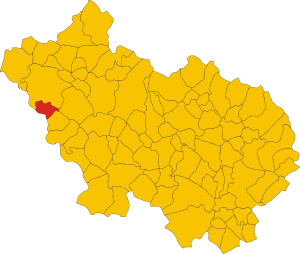
| Property / locator map image | |||||||||||||||
| Property / locator map image: Map of comune of Sgurgola (province of Frosinone, region Lazio, Italy).svg / rank | |||||||||||||||
Normal rank | |||||||||||||||
| Property / locator map image: Map of comune of Sgurgola (province of Frosinone, region Lazio, Italy).svg / reference | |||||||||||||||
| Property / ISTAT ID | |||||||||||||||
060073 | |||||||||||||||
| Property / ISTAT ID: 060073 / rank | |||||||||||||||
Normal rank | |||||||||||||||
| Property / ISTAT ID: 060073 / reference | |||||||||||||||
| Property / country | |||||||||||||||
| Property / country: Italy / rank | |||||||||||||||
Normal rank | |||||||||||||||
| Property / country: Italy / reference | |||||||||||||||
| Property / Italian cadastre code | |||||||||||||||
I716 | |||||||||||||||
| Property / Italian cadastre code: I716 / rank | |||||||||||||||
Normal rank | |||||||||||||||
| Property / Italian cadastre code: I716 / reference | |||||||||||||||
| Property / Freebase ID | |||||||||||||||
| Property / Freebase ID: /m/0gmxsf / rank | |||||||||||||||
Normal rank | |||||||||||||||
| Property / Freebase ID: /m/0gmxsf / reference | |||||||||||||||
| Property / Freebase ID: /m/0gmxsf / reference | |||||||||||||||
publication date: 28 October 2013
| |||||||||||||||
| Property / GND ID | |||||||||||||||
| Property / GND ID: 4784271-4 / rank | |||||||||||||||
Normal rank | |||||||||||||||
| Property / GND ID: 4784271-4 / reference | |||||||||||||||
| Property / VIAF ID | |||||||||||||||
| Property / VIAF ID: 236137526 / rank | |||||||||||||||
Normal rank | |||||||||||||||
| Property / VIAF ID: 236137526 / reference | |||||||||||||||
| Property / topic's main category | |||||||||||||||
| Property / topic's main category: Category:Sgurgola / rank | |||||||||||||||
Normal rank | |||||||||||||||
| Property / topic's main category: Category:Sgurgola / reference | |||||||||||||||
| Property / elevation above sea level | |||||||||||||||
386±1 metre
| |||||||||||||||
| Property / elevation above sea level: 386±1 metre / rank | |||||||||||||||
Normal rank | |||||||||||||||
| Property / elevation above sea level: 386±1 metre / reference | |||||||||||||||
| Property / TGN ID | |||||||||||||||
| Property / TGN ID: 7006678 / rank | |||||||||||||||
Normal rank | |||||||||||||||
| Property / licence plate code | |||||||||||||||
FR | |||||||||||||||
| Property / licence plate code: FR / rank | |||||||||||||||
Normal rank | |||||||||||||||
| Property / coordinates of northernmost point | |||||||||||||||
41°41'42.896"N, 13°7'55.657"E
| |||||||||||||||
| Property / coordinates of northernmost point: 41°41'42.896"N, 13°7'55.657"E / rank | |||||||||||||||
Normal rank | |||||||||||||||
| Property / coordinates of northernmost point: 41°41'42.896"N, 13°7'55.657"E / reference | |||||||||||||||
| Property / coordinates of southernmost point | |||||||||||||||
41°38'50.665"N, 13°9'18.004"E
| |||||||||||||||
| Property / coordinates of southernmost point: 41°38'50.665"N, 13°9'18.004"E / rank | |||||||||||||||
Normal rank | |||||||||||||||
| Property / coordinates of southernmost point: 41°38'50.665"N, 13°9'18.004"E / reference | |||||||||||||||
| Property / coordinates of easternmost point | |||||||||||||||
41°40'25.576"N, 13°11'47.706"E
| |||||||||||||||
| Property / coordinates of easternmost point: 41°40'25.576"N, 13°11'47.706"E / rank | |||||||||||||||
Normal rank | |||||||||||||||
| Property / coordinates of easternmost point: 41°40'25.576"N, 13°11'47.706"E / reference | |||||||||||||||
| Property / coordinates of westernmost point | |||||||||||||||
41°41'14.942"N, 13°6'50.584"E
| |||||||||||||||
| Property / coordinates of westernmost point: 41°41'14.942"N, 13°6'50.584"E / rank | |||||||||||||||
Normal rank | |||||||||||||||
| Property / coordinates of westernmost point: 41°41'14.942"N, 13°6'50.584"E / reference | |||||||||||||||
| Property / OSM relation ID | |||||||||||||||
| Property / OSM relation ID: 41469 / rank | |||||||||||||||
Normal rank | |||||||||||||||
| Property / UN/LOCODE | |||||||||||||||
| Property / UN/LOCODE: ITSG9 / rank | |||||||||||||||
Normal rank | |||||||||||||||
| Property / capital | |||||||||||||||
| Property / capital: Sgurgola / rank | |||||||||||||||
Normal rank | |||||||||||||||
| Property / area | |||||||||||||||
19.22 square kilometre
| |||||||||||||||
| Property / area: 19.22 square kilometre / rank | |||||||||||||||
Normal rank | |||||||||||||||
| Property / area: 19.22 square kilometre / qualifier | |||||||||||||||
point in time: 9 October 2011
| |||||||||||||||
| Property / area: 19.22 square kilometre / reference | |||||||||||||||
| Property / area: 19.22 square kilometre / reference | |||||||||||||||
| Property / area: 19.22 square kilometre / reference | |||||||||||||||
title: Superficie di Comuni Province e Regioni italiane al 9 ottobre 2011 (Italian) | |||||||||||||||
| Property / area: 19.22 square kilometre / reference | |||||||||||||||
retrieved: 16 March 2019
| |||||||||||||||
| Property / area: 19.22 square kilometre / reference | |||||||||||||||
| Property / population | |||||||||||||||
2,667
| |||||||||||||||
| Property / population: 2,667 / rank | |||||||||||||||
Normal rank | |||||||||||||||
| Property / population: 2,667 / qualifier | |||||||||||||||
point in time: 1 January 2017
| |||||||||||||||
| Property / population: 2,667 / qualifier | |||||||||||||||
| Property / population: 2,667 / reference | |||||||||||||||
| Property / population | |||||||||||||||
2,651
| |||||||||||||||
| Property / population: 2,651 / rank | |||||||||||||||
Preferred rank | |||||||||||||||
| Property / population: 2,651 / qualifier | |||||||||||||||
point in time: 1 January 2018
| |||||||||||||||
| Property / population: 2,651 / qualifier | |||||||||||||||
| Property / population: 2,651 / reference | |||||||||||||||
| Property / population: 2,651 / reference | |||||||||||||||
title: Popolazione Residente al 1° Gennaio 2018 (Italian) | |||||||||||||||
| Property / population: 2,651 / reference | |||||||||||||||
retrieved: 16 March 2019
| |||||||||||||||
| Property / population: 2,651 / reference | |||||||||||||||
| Property / population | |||||||||||||||
2,651
| |||||||||||||||
| Property / population: 2,651 / rank | |||||||||||||||
Normal rank | |||||||||||||||
| Property / population: 2,651 / qualifier | |||||||||||||||
point in time: 1 January 2018
| |||||||||||||||
| Property / population: 2,651 / qualifier | |||||||||||||||
| Property / population: 2,651 / reference | |||||||||||||||
| Property / population: 2,651 / reference | |||||||||||||||
title: Popolazione Residente al 1° Gennaio 2018 (Italian) | |||||||||||||||
| Property / population: 2,651 / reference | |||||||||||||||
retrieved: 16 March 2019
| |||||||||||||||
| Property / population: 2,651 / reference | |||||||||||||||
| Property / population | |||||||||||||||
2,370
| |||||||||||||||
| Property / population: 2,370 / rank | |||||||||||||||
Preferred rank | |||||||||||||||
| Property / population: 2,370 / qualifier | |||||||||||||||
point in time: 1 January 2023
| |||||||||||||||
| Property / population: 2,370 / reference | |||||||||||||||
| Property / GeoNames ID | |||||||||||||||
| Property / GeoNames ID: 6538713 / rank | |||||||||||||||
Normal rank | |||||||||||||||
| Property / IndicePA ID | |||||||||||||||
| Property / IndicePA ID: c_i716 / rank | |||||||||||||||
Normal rank | |||||||||||||||
| Property / Who's on First ID | |||||||||||||||
| Property / Who's on First ID: 101850891 / rank | |||||||||||||||
Normal rank | |||||||||||||||
| Property / category for people born here | |||||||||||||||
| Property / category for people born here: Q2613066 / rank | |||||||||||||||
Normal rank | |||||||||||||||
| Property / Wiki Loves Monuments ID | |||||||||||||||
12I7160000 | |||||||||||||||
| Property / Wiki Loves Monuments ID: 12I7160000 / rank | |||||||||||||||
Normal rank | |||||||||||||||
| Property / Wiki Loves Monuments ID: 12I7160000 / qualifier | |||||||||||||||
start time: 1 September 2020
| |||||||||||||||
| Property / Wiki Loves Monuments ID: 12I7160000 / reference | |||||||||||||||
| Property / seismic classification | |||||||||||||||
| Property / seismic classification: 2B / rank | |||||||||||||||
Normal rank | |||||||||||||||
| Property / seismic classification: 2B / reference | |||||||||||||||
| Property / seismic classification: 2B / reference | |||||||||||||||
| Property / seismic classification: 2B / reference | |||||||||||||||
retrieved: 27 August 2022
| |||||||||||||||
| Property / EU Knowledge Graph item ID | |||||||||||||||
Q282622 | |||||||||||||||
| Property / EU Knowledge Graph item ID: Q282622 / rank | |||||||||||||||
Normal rank | |||||||||||||||
| Property / coordinate location | |||||||||||||||
41°40'14.7"N, 13°8'57.6"E
| |||||||||||||||
| Property / coordinate location: 41°40'14.7"N, 13°8'57.6"E / rank | |||||||||||||||
Normal rank | |||||||||||||||
| Property / coordinate location: 41°40'14.7"N, 13°8'57.6"E / reference | |||||||||||||||
| Property / official website | |||||||||||||||
| Property / official website: https://www.comune.sgurgola.fr.it/ / rank | |||||||||||||||
Normal rank | |||||||||||||||
| Property / demonym | |||||||||||||||
sgurgolani (Italian) | |||||||||||||||
| Property / demonym: sgurgolani (Italian) / rank | |||||||||||||||
Normal rank | |||||||||||||||
| Property / demonym: sgurgolani (Italian) / qualifier | |||||||||||||||
| Property / demonym: sgurgolani (Italian) / reference | |||||||||||||||
| links / bgwiki / name | links / bgwiki / name | ||||||||||||||
| links / dewiki / name | links / dewiki / name | ||||||||||||||
| links / enwiki / name | links / enwiki / name | ||||||||||||||
| links / eswiki / name | links / eswiki / name | ||||||||||||||
| links / frwiki / name | links / frwiki / name | ||||||||||||||
| links / huwiki / name | links / huwiki / name | ||||||||||||||
| links / itwiki / name | links / itwiki / name | ||||||||||||||
| links / nlwiki / name | links / nlwiki / name | ||||||||||||||
| links / plwiki / name | links / plwiki / name | ||||||||||||||
| links / ptwiki / name | links / ptwiki / name | ||||||||||||||
| links / rowiki / name | links / rowiki / name | ||||||||||||||
| links / svwiki / name | links / svwiki / name | ||||||||||||||
| links / trwiki / name | links / trwiki / name | ||||||||||||||
Latest revision as of 18:54, 31 July 2024
Italian comune
| Language | Label | Description | Also known as |
|---|---|---|---|
| English | Sgurgola |
Italian comune |
Statements

03010
0 references
Sgurgola
0 references
0775
0 references
.svg)
Map of comune of Sgurgola (province of Frosinone, region Lazio, Italy).svg
6,262 × 5,295; 163 KB
6,262 × 5,295; 163 KB
1 reference
FR
0 references


.svg)
19.22 square kilometre
9 October 2011
5 references
Superficie di Comuni Province e Regioni italiane al 9 ottobre 2011 (Italian)
16 March 2019
2,667
1 January 2017
1 reference
2,651
1 January 2018
4 references
Popolazione Residente al 1° Gennaio 2018 (Italian)
16 March 2019
2,651
1 January 2018
4 references
Popolazione Residente al 1° Gennaio 2018 (Italian)
16 March 2019
sgurgolani (Italian)
1 reference
Identifiers
310610605
0 references
Q282622
0 references