Cadorago (Q260653): Difference between revisions
Jump to navigation
Jump to search
(Changed label, description and/or aliases in 12 languages: Label in wikidata changed) |
(Changed an Item: Adding these statements since they where added in Wikidata) |
||||||||||||||
| (22 intermediate revisions by 2 users not shown) | |||||||||||||||
| label / it | label / it | ||||||||||||||
CADORAGO | |||||||||||||||
| label / tr | label / tr | ||||||||||||||
Cadorago | |||||||||||||||
| label / ga | label / ga | ||||||||||||||
Cadorago | |||||||||||||||
| label / el | label / el | ||||||||||||||
Καντοράγκο | |||||||||||||||
| description / en | description / en | ||||||||||||||
Italian comune | |||||||||||||||
| description / bg | description / bg | ||||||||||||||
италианска община | |||||||||||||||
| description / cs | description / cs | ||||||||||||||
italská obec | |||||||||||||||
| description / de | description / de | ||||||||||||||
italienische Gemeinde | |||||||||||||||
| description / el | description / el | ||||||||||||||
δήμος της Ιταλίας | |||||||||||||||
| description / es | description / es | ||||||||||||||
comuna italiana | |||||||||||||||
| description / fi | description / fi | ||||||||||||||
kunta Italiassa | |||||||||||||||
| description / fr | description / fr | ||||||||||||||
commune italienne | |||||||||||||||
| description / hr | description / hr | ||||||||||||||
Talijanske općine | |||||||||||||||
| description / it | description / it | ||||||||||||||
comune italiano | |||||||||||||||
| description / lt | description / lt | ||||||||||||||
komuna Italijoje | |||||||||||||||
| description / nl | description / nl | ||||||||||||||
Italiaanse gemeente | |||||||||||||||
| description / pl | description / pl | ||||||||||||||
włoska gmina | |||||||||||||||
| description / pt | description / pt | ||||||||||||||
comuna italiana | |||||||||||||||
| description / sv | description / sv | ||||||||||||||
kommun i Italien | |||||||||||||||
| description / tr | description / tr | ||||||||||||||
İtalya'nın Lombardia bölgesinde, Como iline bağlı ilçe (komün) | |||||||||||||||
| description / hu | description / hu | ||||||||||||||
település Olaszországban | |||||||||||||||
| description / ro | description / ro | ||||||||||||||
comună din Italia | |||||||||||||||
| Property / country | |||||||||||||||
| Property / country: Italy / rank | |||||||||||||||
| Property / instance of | |||||||||||||||
| Property / instance of: beneficiary / rank | |||||||||||||||
| Property / instance of | |||||||||||||||
| Property / instance of: commune of Italy / rank | |||||||||||||||
Normal rank | |||||||||||||||
| Property / instance of | |||||||||||||||
| Property / instance of: beneficiary / rank | |||||||||||||||
Preferred rank | |||||||||||||||
| Property / instance of | |||||||||||||||
| Property / instance of: public beneficiary / rank | |||||||||||||||
Normal rank | |||||||||||||||
| Property / instance of: public beneficiary / qualifier | |||||||||||||||
| Property / Commons category | |||||||||||||||
Cadorago | |||||||||||||||
| Property / Commons category: Cadorago / rank | |||||||||||||||
Normal rank | |||||||||||||||
| Property / located in the administrative territorial entity | |||||||||||||||
| Property / located in the administrative territorial entity: Province of Como / rank | |||||||||||||||
Normal rank | |||||||||||||||
| Property / postal code | |||||||||||||||
22071 | |||||||||||||||
| Property / postal code: 22071 / rank | |||||||||||||||
Normal rank | |||||||||||||||
| Property / shares border with | |||||||||||||||
| Property / shares border with: Bregnano / rank | |||||||||||||||
Normal rank | |||||||||||||||
| Property / shares border with | |||||||||||||||
| Property / shares border with: Fino Mornasco / rank | |||||||||||||||
Normal rank | |||||||||||||||
| Property / shares border with | |||||||||||||||
| Property / shares border with: Guanzate / rank | |||||||||||||||
Normal rank | |||||||||||||||
| Property / shares border with | |||||||||||||||
| Property / shares border with: Lomazzo / rank | |||||||||||||||
Normal rank | |||||||||||||||
| Property / shares border with | |||||||||||||||
| Property / shares border with: Vertemate con Minoprio / rank | |||||||||||||||
Normal rank | |||||||||||||||
| Property / patron saint | |||||||||||||||
| Property / patron saint: Martin of Tours / rank | |||||||||||||||
Normal rank | |||||||||||||||
| Property / located in time zone | |||||||||||||||
| Property / located in time zone: UTC+01:00 / rank | |||||||||||||||
Normal rank | |||||||||||||||
| Property / located in time zone: UTC+01:00 / qualifier | |||||||||||||||
| Property / located in time zone | |||||||||||||||
| Property / located in time zone: UTC+02:00 / rank | |||||||||||||||
Normal rank | |||||||||||||||
| Property / located in time zone: UTC+02:00 / qualifier | |||||||||||||||
| Property / local dialing code | |||||||||||||||
031 | |||||||||||||||
| Property / local dialing code: 031 / rank | |||||||||||||||
Normal rank | |||||||||||||||
| Property / ISTAT ID | |||||||||||||||
013036 | |||||||||||||||
| Property / ISTAT ID: 013036 / rank | |||||||||||||||
Normal rank | |||||||||||||||
| Property / ISTAT ID: 013036 / reference | |||||||||||||||
| Property / coordinate location | |||||||||||||||
45°43'0"N, 9°2'0"E
| |||||||||||||||
| Property / coordinate location: 45°43'0"N, 9°2'0"E / rank | |||||||||||||||
Normal rank | |||||||||||||||
| Property / coordinate location: 45°43'0"N, 9°2'0"E / reference | |||||||||||||||
| Property / country | |||||||||||||||
| Property / country: Italy / rank | |||||||||||||||
Normal rank | |||||||||||||||
| Property / country: Italy / reference | |||||||||||||||
| Property / Italian cadastre code | |||||||||||||||
B346 | |||||||||||||||
| Property / Italian cadastre code: B346 / rank | |||||||||||||||
Normal rank | |||||||||||||||
| Property / Italian cadastre code: B346 / reference | |||||||||||||||
| Property / Freebase ID | |||||||||||||||
| Property / Freebase ID: /m/0gh_h6 / rank | |||||||||||||||
Normal rank | |||||||||||||||
| Property / Freebase ID: /m/0gh_h6 / reference | |||||||||||||||
| Property / Freebase ID: /m/0gh_h6 / reference | |||||||||||||||
publication date: 28 October 2013
| |||||||||||||||
| Property / GeoNames ID | |||||||||||||||
| Property / GeoNames ID: 6542482 / rank | |||||||||||||||
Normal rank | |||||||||||||||
| Property / GeoNames ID: 6542482 / reference | |||||||||||||||
| Property / official website | |||||||||||||||
| Property / official website: http://www.comune.cadorago.co.it / rank | |||||||||||||||
Normal rank | |||||||||||||||
| Property / official website: http://www.comune.cadorago.co.it / reference | |||||||||||||||
| Property / elevation above sea level | |||||||||||||||
313±1 metre
| |||||||||||||||
| Property / elevation above sea level: 313±1 metre / rank | |||||||||||||||
Normal rank | |||||||||||||||
| Property / elevation above sea level: 313±1 metre / reference | |||||||||||||||
| Property / topic's main category | |||||||||||||||
| Property / topic's main category: Category:Cadorago / rank | |||||||||||||||
Normal rank | |||||||||||||||
| Property / licence plate code | |||||||||||||||
CO | |||||||||||||||
| Property / licence plate code: CO / rank | |||||||||||||||
Normal rank | |||||||||||||||
| Property / coordinates of northernmost point | |||||||||||||||
45°44'23.014"N, 9°2'15.972"E
| |||||||||||||||
| Property / coordinates of northernmost point: 45°44'23.014"N, 9°2'15.972"E / rank | |||||||||||||||
Normal rank | |||||||||||||||
| Property / coordinates of northernmost point: 45°44'23.014"N, 9°2'15.972"E / reference | |||||||||||||||
| Property / coordinates of southernmost point | |||||||||||||||
45°42'12.074"N, 9°2'27.323"E
| |||||||||||||||
| Property / coordinates of southernmost point: 45°42'12.074"N, 9°2'27.323"E / rank | |||||||||||||||
Normal rank | |||||||||||||||
| Property / coordinates of southernmost point: 45°42'12.074"N, 9°2'27.323"E / reference | |||||||||||||||
| Property / coordinates of easternmost point | |||||||||||||||
45°43'13.030"N, 9°4'21.259"E
| |||||||||||||||
| Property / coordinates of easternmost point: 45°43'13.030"N, 9°4'21.259"E / rank | |||||||||||||||
Normal rank | |||||||||||||||
| Property / coordinates of easternmost point: 45°43'13.030"N, 9°4'21.259"E / reference | |||||||||||||||
| Property / coordinates of westernmost point | |||||||||||||||
45°42'52.445"N, 9°1'25.082"E
| |||||||||||||||
| Property / coordinates of westernmost point: 45°42'52.445"N, 9°1'25.082"E / rank | |||||||||||||||
Normal rank | |||||||||||||||
| Property / coordinates of westernmost point: 45°42'52.445"N, 9°1'25.082"E / reference | |||||||||||||||
| Property / OSM relation ID | |||||||||||||||
| Property / OSM relation ID: 45852 / rank | |||||||||||||||
Normal rank | |||||||||||||||
| Property / area | |||||||||||||||
7.19 square kilometre
| |||||||||||||||
| Property / area: 7.19 square kilometre / rank | |||||||||||||||
Normal rank | |||||||||||||||
| Property / area: 7.19 square kilometre / qualifier | |||||||||||||||
point in time: 9 October 2011
| |||||||||||||||
| Property / area: 7.19 square kilometre / reference | |||||||||||||||
| Property / area: 7.19 square kilometre / reference | |||||||||||||||
| Property / area: 7.19 square kilometre / reference | |||||||||||||||
title: Superficie di Comuni Province e Regioni italiane al 9 ottobre 2011 (Italian) | |||||||||||||||
| Property / area: 7.19 square kilometre / reference | |||||||||||||||
retrieved: 16 March 2019
| |||||||||||||||
| Property / area: 7.19 square kilometre / reference | |||||||||||||||
| Property / population | |||||||||||||||
7,919
| |||||||||||||||
| Property / population: 7,919 / rank | |||||||||||||||
Normal rank | |||||||||||||||
| Property / population: 7,919 / qualifier | |||||||||||||||
point in time: 1 January 2017
| |||||||||||||||
| Property / population: 7,919 / qualifier | |||||||||||||||
| Property / population: 7,919 / reference | |||||||||||||||
| Property / population | |||||||||||||||
7,979
| |||||||||||||||
| Property / population: 7,979 / rank | |||||||||||||||
Preferred rank | |||||||||||||||
| Property / population: 7,979 / qualifier | |||||||||||||||
point in time: 1 January 2018
| |||||||||||||||
| Property / population: 7,979 / qualifier | |||||||||||||||
| Property / population: 7,979 / reference | |||||||||||||||
| Property / population: 7,979 / reference | |||||||||||||||
title: Popolazione Residente al 1° Gennaio 2018 (Italian) | |||||||||||||||
| Property / population: 7,979 / reference | |||||||||||||||
retrieved: 16 March 2019
| |||||||||||||||
| Property / population: 7,979 / reference | |||||||||||||||
| Property / population | |||||||||||||||
7,979
| |||||||||||||||
| Property / population: 7,979 / rank | |||||||||||||||
Normal rank | |||||||||||||||
| Property / population: 7,979 / qualifier | |||||||||||||||
point in time: 1 January 2018
| |||||||||||||||
| Property / population: 7,979 / qualifier | |||||||||||||||
| Property / population: 7,979 / reference | |||||||||||||||
| Property / population: 7,979 / reference | |||||||||||||||
title: Popolazione Residente al 1° Gennaio 2018 (Italian) | |||||||||||||||
| Property / population: 7,979 / reference | |||||||||||||||
retrieved: 16 March 2019
| |||||||||||||||
| Property / population: 7,979 / reference | |||||||||||||||
| Property / population | |||||||||||||||
7,983
| |||||||||||||||
| Property / population: 7,983 / rank | |||||||||||||||
Preferred rank | |||||||||||||||
| Property / population: 7,983 / qualifier | |||||||||||||||
point in time: 1 January 2023
| |||||||||||||||
| Property / population: 7,983 / reference | |||||||||||||||
| Property / UN/LOCODE | |||||||||||||||
| Property / UN/LOCODE: ITCDR / rank | |||||||||||||||
Normal rank | |||||||||||||||
| Property / LombardiaBeniCulturali toponym ID | |||||||||||||||
3000068 | |||||||||||||||
| Property / LombardiaBeniCulturali toponym ID: 3000068 / rank | |||||||||||||||
Normal rank | |||||||||||||||
| Property / IndicePA ID | |||||||||||||||
| Property / IndicePA ID: c_b346 / rank | |||||||||||||||
Normal rank | |||||||||||||||
| Property / Who's on First ID | |||||||||||||||
| Property / Who's on First ID: 404467985 / rank | |||||||||||||||
Normal rank | |||||||||||||||
| Property / Wiki Loves Monuments ID | |||||||||||||||
03B3460000 | |||||||||||||||
| Property / Wiki Loves Monuments ID: 03B3460000 / rank | |||||||||||||||
Normal rank | |||||||||||||||
| Property / Wiki Loves Monuments ID: 03B3460000 / qualifier | |||||||||||||||
start time: 1 September 2020
| |||||||||||||||
| Property / Wiki Loves Monuments ID: 03B3460000 / reference | |||||||||||||||
| Property / seismic classification | |||||||||||||||
| Property / seismic classification: 4 / rank | |||||||||||||||
Normal rank | |||||||||||||||
| Property / seismic classification: 4 / reference | |||||||||||||||
| Property / seismic classification: 4 / reference | |||||||||||||||
| Property / seismic classification: 4 / reference | |||||||||||||||
retrieved: 27 August 2022
| |||||||||||||||
| Property / EU Knowledge Graph item ID | |||||||||||||||
Q260653 | |||||||||||||||
| Property / EU Knowledge Graph item ID: Q260653 / rank | |||||||||||||||
Normal rank | |||||||||||||||
| Property / image | |||||||||||||||
| Property / image: Cadorago - frazione Caslino al Piano - santuario di Sant’Anna.jpg / rank | |||||||||||||||
Normal rank | |||||||||||||||
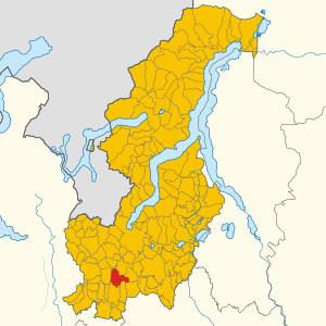
| Property / locator map image | |||||||||||||||
| Property / locator map image: Map of Cadorago (Province of Como, region Lombardy, Italy 2023).svg / rank | |||||||||||||||
Normal rank | |||||||||||||||
| Property / demonym | |||||||||||||||
cadoraghesi (Italian) | |||||||||||||||
| Property / demonym: cadoraghesi (Italian) / rank | |||||||||||||||
Normal rank | |||||||||||||||
| Property / demonym: cadoraghesi (Italian) / qualifier | |||||||||||||||
| Property / demonym: cadoraghesi (Italian) / reference | |||||||||||||||
| links / bgwiki / name | links / bgwiki / name | ||||||||||||||
| links / dewiki / name | links / dewiki / name | ||||||||||||||
| links / enwiki / name | links / enwiki / name | ||||||||||||||
| links / eswiki / name | links / eswiki / name | ||||||||||||||
| links / frwiki / name | links / frwiki / name | ||||||||||||||
| links / huwiki / name | links / huwiki / name | ||||||||||||||
| links / itwiki / name | links / itwiki / name | ||||||||||||||
| links / nlwiki / name | links / nlwiki / name | ||||||||||||||
| links / plwiki / name | links / plwiki / name | ||||||||||||||
| links / ptwiki / name | links / ptwiki / name | ||||||||||||||
| links / rowiki / name | links / rowiki / name | ||||||||||||||
| links / svwiki / name | links / svwiki / name | ||||||||||||||
| links / trwiki / name | links / trwiki / name | ||||||||||||||
Latest revision as of 09:37, 9 August 2024
Italian comune
| Language | Label | Description | Also known as |
|---|---|---|---|
| English | Cadorago |
Italian comune |
Statements

22071
0 references
Cadorago
0 references
031
0 references
CO
0 references


7.19 square kilometre
9 October 2011
5 references
Superficie di Comuni Province e Regioni italiane al 9 ottobre 2011 (Italian)
16 March 2019
7,919
1 January 2017
1 reference
7,979
1 January 2018
4 references
Popolazione Residente al 1° Gennaio 2018 (Italian)
16 March 2019
7,979
1 January 2018
4 references
Popolazione Residente al 1° Gennaio 2018 (Italian)
16 March 2019

.svg)
.svg)
Map of Cadorago (Province of Como, region Lombardy, Italy 2023).svg
1,250 × 1,250; 1.72 MB
1,250 × 1,250; 1.72 MB
0 references
cadoraghesi (Italian)
1 reference
Identifiers
696750132
0 references
3000068
0 references
Q260653
0 references