Scoppito (Q278054): Difference between revisions
Jump to navigation
Jump to search
(Changed an Item: Adding this statements since they where added in Wikidata) |
(Changed label, description and/or aliases in sl: The description in Wikidata changed) |
||||||||||||||
| (20 intermediate revisions by 2 users not shown) | |||||||||||||||
| label / it | label / it | ||||||||||||||
SCOPPITO | |||||||||||||||
| label / tr | label / tr | ||||||||||||||
Scoppito | |||||||||||||||
| label / ga | label / ga | ||||||||||||||
Scoppito | |||||||||||||||
| label / sl | label / sl | ||||||||||||||
Scoppito | |||||||||||||||
| description / tr | description / tr | ||||||||||||||
İtalya'nın | İtalya'nın Abruzzo bölgesinde, Aquila iline bağlı ilçe (komün) | ||||||||||||||
| description / sl | description / sl | ||||||||||||||
italijanska občina | |||||||||||||||
| Property / instance of | |||||||||||||||
| Property / instance of: beneficiary / rank | |||||||||||||||
| Property / De Agostini ID | |||||||||||||||
| Property / De Agostini ID: Scoppito / rank | |||||||||||||||
| Property / instance of | |||||||||||||||
| Property / instance of: beneficiary / rank | |||||||||||||||
Preferred rank | |||||||||||||||
| Property / instance of | |||||||||||||||
| Property / instance of: public beneficiary / rank | |||||||||||||||
Normal rank | |||||||||||||||
| Property / instance of: public beneficiary / qualifier | |||||||||||||||
| Property / population | |||||||||||||||
3,805
| |||||||||||||||
| Property / population: 3,805 / rank | |||||||||||||||
Normal rank | |||||||||||||||
| Property / population: 3,805 / qualifier | |||||||||||||||
point in time: 1 January 2018
| |||||||||||||||
| Property / population: 3,805 / qualifier | |||||||||||||||
| Property / population: 3,805 / reference | |||||||||||||||
| Property / population: 3,805 / reference | |||||||||||||||
title: Popolazione Residente al 1° Gennaio 2018 (Italian) | |||||||||||||||
| Property / population: 3,805 / reference | |||||||||||||||
retrieved: 16 March 2019
| |||||||||||||||
| Property / population: 3,805 / reference | |||||||||||||||
| Property / population | |||||||||||||||
3,740
| |||||||||||||||
| Property / population: 3,740 / rank | |||||||||||||||
Preferred rank | |||||||||||||||
| Property / population: 3,740 / qualifier | |||||||||||||||
point in time: 1 January 2023
| |||||||||||||||
| Property / population: 3,740 / reference | |||||||||||||||
| Property / Wiki Loves Monuments ID | |||||||||||||||
13I5460000 | |||||||||||||||
| Property / Wiki Loves Monuments ID: 13I5460000 / rank | |||||||||||||||
Normal rank | |||||||||||||||
| Property / Wiki Loves Monuments ID: 13I5460000 / qualifier | |||||||||||||||
start time: 1 September 2020
| |||||||||||||||
| Property / Wiki Loves Monuments ID: 13I5460000 / reference | |||||||||||||||
| Property / image | |||||||||||||||
| Property / image: Scoppito - Chiesa di San Giacomo Apostolo 03.jpg / rank | |||||||||||||||
Normal rank | |||||||||||||||
| Property / De Agostini ID | |||||||||||||||
| Property / De Agostini ID: Scoppito / rank | |||||||||||||||
Normal rank | |||||||||||||||
| Property / De Agostini ID: Scoppito / qualifier | |||||||||||||||
named as: Scoppito | |||||||||||||||
| Property / seismic classification | |||||||||||||||
| Property / seismic classification: 2 / rank | |||||||||||||||
Normal rank | |||||||||||||||
| Property / seismic classification: 2 / reference | |||||||||||||||
| Property / seismic classification: 2 / reference | |||||||||||||||
| Property / seismic classification: 2 / reference | |||||||||||||||
retrieved: 27 August 2022
| |||||||||||||||
| Property / EU Knowledge Graph item ID | |||||||||||||||
Q278054 | |||||||||||||||
| Property / EU Knowledge Graph item ID: Q278054 / rank | |||||||||||||||
Normal rank | |||||||||||||||
| Property / native label | |||||||||||||||
Scoppito (Italian) | |||||||||||||||
| Property / native label: Scoppito (Italian) / rank | |||||||||||||||
Normal rank | |||||||||||||||
| Property / native label: Scoppito (Italian) / reference | |||||||||||||||
| Property / native label: Scoppito (Italian) / reference | |||||||||||||||
| Property / official name | |||||||||||||||
Scoppito (Italian) | |||||||||||||||
| Property / official name: Scoppito (Italian) / rank | |||||||||||||||
Normal rank | |||||||||||||||
| Property / official name: Scoppito (Italian) / reference | |||||||||||||||
| Property / official name: Scoppito (Italian) / reference | |||||||||||||||
| Property / demonym | |||||||||||||||
scoppitani (Italian) | |||||||||||||||
| Property / demonym: scoppitani (Italian) / rank | |||||||||||||||
Normal rank | |||||||||||||||
| Property / demonym: scoppitani (Italian) / qualifier | |||||||||||||||
| Property / demonym: scoppitani (Italian) / reference | |||||||||||||||
| links / trwiki / name | links / trwiki / name | ||||||||||||||
Latest revision as of 04:33, 8 December 2024
Italian comune
| Language | Label | Description | Also known as |
|---|---|---|---|
| English | Scoppito |
Italian comune |
Statements
67019
0 references
Scoppito
0 references
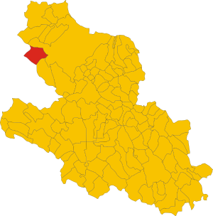
Map of comune of Scoppito (province of L'Aquila, region Abruzzo, Italy).svg
3,214 × 3,258; 189 KB
3,214 × 3,258; 189 KB
1 reference
AQ
0 references
53 square kilometre
9 October 2011
5 references
Superficie di Comuni Province e Regioni italiane al 9 ottobre 2011 (Italian)
16 March 2019
3,730
1 January 2017
1 reference
3,805
1 January 2018
4 references
Popolazione Residente al 1° Gennaio 2018 (Italian)
16 March 2019
3,805
1 January 2018
4 references
Popolazione Residente al 1° Gennaio 2018 (Italian)
16 March 2019
Scoppito (Italian)
Scoppito (Italian)
scoppitani (Italian)
1 reference
Identifiers
183860667
0 references
4430135536708331409
0 references
Q278054
0 references


