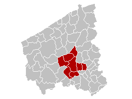
Arrondissement of Roeselare (Q2572228): Difference between revisions
Jump to navigation
Jump to search
(Changed an Item: Adding these statements since they where added in Wikidata) |
(Changed label, description and/or aliases in pl: Label in wikidata changed) |
||
| (7 intermediate revisions by 2 users not shown) | |||
| label / ga | label / ga | ||
Arrondissement Roeselare | |||
| label / pl | label / pl | ||
Roeselare (okręg) | |||
| description / nl | description / nl | ||
bestuurlijke arrondissement in de provincie West-Vlaanderen, België | |||
| Property / instance of: 2016 NUTS 3 statistical territorial entity / rank | Property / instance of: 2016 NUTS 3 statistical territorial entity / rank | ||
Normal rank | |||
| Property / instance of | |||
| Property / instance of: 2021 NUTS 3 statistical territorial entity / rank | |||
Preferred rank | |||
| Property / EU Knowledge Graph item ID | |||
Q2572228 | |||
| Property / EU Knowledge Graph item ID: Q2572228 / rank | |||
Normal rank | |||
| Property / OSM relation ID | |||
| Property / OSM relation ID: 2239123 / rank | |||
Normal rank | |||
| Property / NIS/INS code | |||
36000 | |||
| Property / NIS/INS code: 36000 / rank | |||
Normal rank | |||
| Property / iNaturalist place ID | |||
| Property / iNaturalist place ID: 15005 / rank | |||
Normal rank | |||
| Property / GADM ID | |||
BEL.2.5.6_1 | |||
| Property / GADM ID: BEL.2.5.6_1 / rank | |||
Normal rank | |||
| Property / GNS Unique Feature ID | |||
-1968558 | |||
| Property / GNS Unique Feature ID: -1968558 / rank | |||
Normal rank | |||
Latest revision as of 08:59, 1 July 2024
1 of 43 administrative arrondissements of Belgium
| Language | Label | Description | Also known as |
|---|---|---|---|
| English | Arrondissement of Roeselare |
1 of 43 administrative arrondissements of Belgium |
Statements
271.54 square kilometre
Identifiers
Q2572228
0 references
36000
0 references
BEL.2.5.6_1
0 references
-1968558
0 references


