Cupramontana (Q260824): Difference between revisions
Jump to navigation
Jump to search
(Changed an Item: Adding this statements since they where added in Wikidata) |
(Changed an Item: Adding this statements since they where added in Wikidata) |
||||||||||||||
| Property / instance of | |||||||||||||||
| Property / instance of: commune of Italy / rank | |||||||||||||||
Normal rank | |||||||||||||||
| Property / Freebase ID | |||||||||||||||
| Property / Freebase ID: /m/0gl5pj / rank | |||||||||||||||
Normal rank | |||||||||||||||
| Property / Freebase ID: /m/0gl5pj / reference | |||||||||||||||
| Property / Freebase ID: /m/0gl5pj / reference | |||||||||||||||
publication date: 28 October 2013
| |||||||||||||||
| Property / twinned administrative body | |||||||||||||||
| Property / twinned administrative body: Gessopalena / rank | |||||||||||||||
Normal rank | |||||||||||||||
| Property / twinned administrative body: Gessopalena / reference | |||||||||||||||
| Property / GND ID | |||||||||||||||
| Property / GND ID: 4526882-4 / rank | |||||||||||||||
Normal rank | |||||||||||||||
| Property / GND ID: 4526882-4 / reference | |||||||||||||||
| Property / category for people who died here | |||||||||||||||
| Property / category for people who died here: Category:Deaths in Cupramontana / rank | |||||||||||||||
Normal rank | |||||||||||||||
| Property / category for people who died here: Category:Deaths in Cupramontana / reference | |||||||||||||||
| Property / category for people born here | |||||||||||||||
| Property / category for people born here: Category:Births in Cupramontana / rank | |||||||||||||||
Normal rank | |||||||||||||||
| Property / category for people born here: Category:Births in Cupramontana / reference | |||||||||||||||
| Property / VIAF ID | |||||||||||||||
| Property / VIAF ID: 168697254 / rank | |||||||||||||||
Normal rank | |||||||||||||||
| Property / VIAF ID: 168697254 / reference | |||||||||||||||
| Property / topic's main category | |||||||||||||||
| Property / topic's main category: Category:Cupramontana / rank | |||||||||||||||
Normal rank | |||||||||||||||
| Property / topic's main category: Category:Cupramontana / reference | |||||||||||||||
| Property / official website | |||||||||||||||
| Property / official website: http://www.comune.cupramontana.an.it / rank | |||||||||||||||
Normal rank | |||||||||||||||
| Property / official website: http://www.comune.cupramontana.an.it / reference | |||||||||||||||
| Property / image | |||||||||||||||
| Property / image: Verdicchio vines in Cupramontana.jpg / rank | |||||||||||||||
Normal rank | |||||||||||||||
| Property / image: Verdicchio vines in Cupramontana.jpg / reference | |||||||||||||||
| Property / Digital Atlas of the Roman Empire ID | |||||||||||||||
| Property / Digital Atlas of the Roman Empire ID: 22586 / rank | |||||||||||||||
Normal rank | |||||||||||||||
| Property / elevation above sea level | |||||||||||||||
505±1 metre
| |||||||||||||||
| Property / elevation above sea level: 505±1 metre / rank | |||||||||||||||
Normal rank | |||||||||||||||
| Property / elevation above sea level: 505±1 metre / reference | |||||||||||||||
| Property / TGN ID | |||||||||||||||
| Property / TGN ID: 1044447 / rank | |||||||||||||||
Normal rank | |||||||||||||||
| Property / coordinate location | |||||||||||||||
43°26'45.53"N, 13°7'2.53"E
| |||||||||||||||
| Property / coordinate location: 43°26'45.53"N, 13°7'2.53"E / rank | |||||||||||||||
Normal rank | |||||||||||||||
| Property / coordinate location: 43°26'45.53"N, 13°7'2.53"E / reference | |||||||||||||||
| Property / licence plate code | |||||||||||||||
AN | |||||||||||||||
| Property / licence plate code: AN / rank | |||||||||||||||
Normal rank | |||||||||||||||
| Property / WOEID | |||||||||||||||
| Property / WOEID: 714925 / rank | |||||||||||||||
Normal rank | |||||||||||||||
| Property / WOEID: 714925 / reference | |||||||||||||||
| Property / coordinates of northernmost point | |||||||||||||||
43°28'49.609"N, 13°10'37.556"E
| |||||||||||||||
| Property / coordinates of northernmost point: 43°28'49.609"N, 13°10'37.556"E / rank | |||||||||||||||
Normal rank | |||||||||||||||
| Property / coordinates of northernmost point: 43°28'49.609"N, 13°10'37.556"E / reference | |||||||||||||||
| Property / coordinates of southernmost point | |||||||||||||||
43°24'59.569"N, 13°8'36.665"E
| |||||||||||||||
| Property / coordinates of southernmost point: 43°24'59.569"N, 13°8'36.665"E / rank | |||||||||||||||
Normal rank | |||||||||||||||
| Property / coordinates of southernmost point: 43°24'59.569"N, 13°8'36.665"E / reference | |||||||||||||||
| Property / coordinates of easternmost point | |||||||||||||||
43°28'36.415"N, 13°10'47.348"E
| |||||||||||||||
| Property / coordinates of easternmost point: 43°28'36.415"N, 13°10'47.348"E / rank | |||||||||||||||
Normal rank | |||||||||||||||
| Property / coordinates of easternmost point: 43°28'36.415"N, 13°10'47.348"E / reference | |||||||||||||||
| Property / coordinates of westernmost point | |||||||||||||||
43°27'56.610"N, 13°3'40.111"E
| |||||||||||||||
| Property / coordinates of westernmost point: 43°27'56.610"N, 13°3'40.111"E / rank | |||||||||||||||
Normal rank | |||||||||||||||
| Property / coordinates of westernmost point: 43°27'56.610"N, 13°3'40.111"E / reference | |||||||||||||||
Revision as of 04:31, 6 August 2020
Italian comune
| Language | Label | Description | Also known as |
|---|---|---|---|
| English | Cupramontana |
Italian comune |
Statements
Cupramontana
0 references
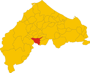
Map of comune of Cupramontana (province of Ancona, region Marche, Italy).svg
8,334 × 6,784; 91 KB
8,334 × 6,784; 91 KB
1 reference
AN
0 references
Identifiers
208390427
0 references
2--45671
0 references


