Cinigiano (Q262962): Difference between revisions
Jump to navigation
Jump to search
(Changed an Item: Adding this statements since they where added in Wikidata) |
(Changed an Item: Adding this statements since they where added in Wikidata) |
||||||||||||||
| Property / GeoNames ID | |||||||||||||||
| Property / GeoNames ID: 6541105 / rank | |||||||||||||||
Normal rank | |||||||||||||||
| Property / GeoNames ID: 6541105 / reference | |||||||||||||||
| Property / GND ID | |||||||||||||||
| Property / GND ID: 4643158-5 / rank | |||||||||||||||
Normal rank | |||||||||||||||
| Property / GND ID: 4643158-5 / reference | |||||||||||||||
| Property / category for people who died here | |||||||||||||||
| Property / category for people who died here: Category:Deaths in Cinigiano / rank | |||||||||||||||
Normal rank | |||||||||||||||
| Property / category for people who died here: Category:Deaths in Cinigiano / reference | |||||||||||||||
| Property / category for people born here | |||||||||||||||
| Property / category for people born here: Q2609956 / rank | |||||||||||||||
Normal rank | |||||||||||||||
| Property / category for people born here: Q2609956 / reference | |||||||||||||||
| Property / topic's main category | |||||||||||||||
| Property / topic's main category: Category:Cinigiano / rank | |||||||||||||||
Normal rank | |||||||||||||||
| Property / topic's main category: Category:Cinigiano / reference | |||||||||||||||
| Property / VIAF ID | |||||||||||||||
| Property / VIAF ID: 245843049 / rank | |||||||||||||||
Normal rank | |||||||||||||||
| Property / VIAF ID: 245843049 / reference | |||||||||||||||
| Property / VIAF ID: 245843049 / reference | |||||||||||||||
retrieved: 3 August 2015
| |||||||||||||||
| Property / elevation above sea level | |||||||||||||||
324±1 metre
| |||||||||||||||
| Property / elevation above sea level: 324±1 metre / rank | |||||||||||||||
Normal rank | |||||||||||||||
| Property / elevation above sea level: 324±1 metre / reference | |||||||||||||||
| Property / licence plate code | |||||||||||||||
GR | |||||||||||||||
| Property / licence plate code: GR / rank | |||||||||||||||
Normal rank | |||||||||||||||
| Property / coordinates of northernmost point | |||||||||||||||
42°58'19.258"N, 11°21'1.408"E
| |||||||||||||||
| Property / coordinates of northernmost point: 42°58'19.258"N, 11°21'1.408"E / rank | |||||||||||||||
Normal rank | |||||||||||||||
| Property / coordinates of northernmost point: 42°58'19.258"N, 11°21'1.408"E / reference | |||||||||||||||
| Property / coordinates of southernmost point | |||||||||||||||
42°49'51.064"N, 11°20'13.884"E
| |||||||||||||||
| Property / coordinates of southernmost point: 42°49'51.064"N, 11°20'13.884"E / rank | |||||||||||||||
Normal rank | |||||||||||||||
| Property / coordinates of southernmost point: 42°49'51.064"N, 11°20'13.884"E / reference | |||||||||||||||
| Property / coordinates of easternmost point | |||||||||||||||
42°52'58.922"N, 11°30'15.797"E
| |||||||||||||||
| Property / coordinates of easternmost point: 42°52'58.922"N, 11°30'15.797"E / rank | |||||||||||||||
Normal rank | |||||||||||||||
| Property / coordinates of easternmost point: 42°52'58.922"N, 11°30'15.797"E / reference | |||||||||||||||
| Property / coordinates of westernmost point | |||||||||||||||
42°55'46.967"N, 11°16'15.665"E
| |||||||||||||||
| Property / coordinates of westernmost point: 42°55'46.967"N, 11°16'15.665"E / rank | |||||||||||||||
Normal rank | |||||||||||||||
| Property / coordinates of westernmost point: 42°55'46.967"N, 11°16'15.665"E / reference | |||||||||||||||
| Property / OSM relation ID | |||||||||||||||
| Property / OSM relation ID: 42230 / rank | |||||||||||||||
Normal rank | |||||||||||||||
| Property / UN/LOCODE | |||||||||||||||
| Property / UN/LOCODE: ITCQO / rank | |||||||||||||||
Normal rank | |||||||||||||||
| Property / capital | |||||||||||||||
| Property / capital: Cinigiano / rank | |||||||||||||||
Normal rank | |||||||||||||||
| Property / area | |||||||||||||||
161.55 square kilometre
| |||||||||||||||
| Property / area: 161.55 square kilometre / rank | |||||||||||||||
Normal rank | |||||||||||||||
| Property / area: 161.55 square kilometre / qualifier | |||||||||||||||
point in time: 9 October 2011
| |||||||||||||||
| Property / area: 161.55 square kilometre / reference | |||||||||||||||
| Property / area: 161.55 square kilometre / reference | |||||||||||||||
| Property / area: 161.55 square kilometre / reference | |||||||||||||||
title: Superficie di Comuni Province e Regioni italiane al 9 ottobre 2011 (Italian) | |||||||||||||||
| Property / area: 161.55 square kilometre / reference | |||||||||||||||
retrieved: 16 March 2019
| |||||||||||||||
| Property / area: 161.55 square kilometre / reference | |||||||||||||||
| Property / population | |||||||||||||||
2,580
| |||||||||||||||
| Property / population: 2,580 / rank | |||||||||||||||
Normal rank | |||||||||||||||
| Property / population: 2,580 / qualifier | |||||||||||||||
point in time: 1 January 2017
| |||||||||||||||
| Property / population: 2,580 / qualifier | |||||||||||||||
| Property / population: 2,580 / reference | |||||||||||||||
| Property / population | |||||||||||||||
2,536
| |||||||||||||||
| Property / population: 2,536 / rank | |||||||||||||||
Preferred rank | |||||||||||||||
| Property / population: 2,536 / qualifier | |||||||||||||||
point in time: 1 January 2018
| |||||||||||||||
| Property / population: 2,536 / qualifier | |||||||||||||||
| Property / population: 2,536 / reference | |||||||||||||||
| Property / population: 2,536 / reference | |||||||||||||||
title: Popolazione Residente al 1° Gennaio 2018 (Italian) | |||||||||||||||
| Property / population: 2,536 / reference | |||||||||||||||
retrieved: 16 March 2019
| |||||||||||||||
| Property / population: 2,536 / reference | |||||||||||||||
| Property / IndicePA ID | |||||||||||||||
| Property / IndicePA ID: c_c705 / rank | |||||||||||||||
Normal rank | |||||||||||||||
| Property / Who's on First ID | |||||||||||||||
| Property / Who's on First ID: 101800075 / rank | |||||||||||||||
Normal rank | |||||||||||||||
Revision as of 02:25, 6 August 2020
Italian comune
| Language | Label | Description | Also known as |
|---|---|---|---|
| English | Cinigiano |
Italian comune |
Statements

Cinigiano
0 references
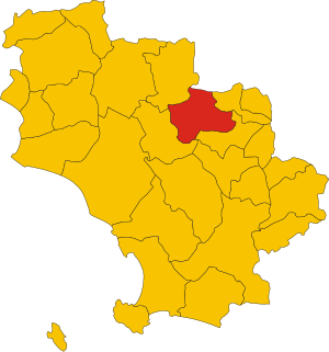
.svg)
Map of comune of Cinigiano (province of Grosseto, region Tuscany, Italy).svg
3,918 × 4,187; 97 KB
3,918 × 4,187; 97 KB
1 reference

GR
0 references


161.55 square kilometre
9 October 2011
5 references
Superficie di Comuni Province e Regioni italiane al 9 ottobre 2011 (Italian)
16 March 2019
2,580
1 January 2017
1 reference
2,536
1 January 2018
4 references
Popolazione Residente al 1° Gennaio 2018 (Italian)
16 March 2019
Identifiers
117340539
0 references