Careggine (Q290895): Difference between revisions
Jump to navigation
Jump to search
(Changed an Item: Adding this statements since they where added in Wikidata) |
(Changed an Item: Adding this statements since they where added in Wikidata) |
||||||||||||||
| Property / image | |||||||||||||||
| Property / image: CaregginePanorama2.jpg / rank | |||||||||||||||
Normal rank | |||||||||||||||
| Property / GND ID | |||||||||||||||
| Property / GND ID: 7644168-4 / rank | |||||||||||||||
Normal rank | |||||||||||||||
| Property / GND ID: 7644168-4 / reference | |||||||||||||||
| Property / topic's main category | |||||||||||||||
| Property / topic's main category: Category:Careggine / rank | |||||||||||||||
Normal rank | |||||||||||||||
| Property / topic's main category: Category:Careggine / reference | |||||||||||||||
| Property / official website | |||||||||||||||
| Property / official website: http://www.careggine.org / rank | |||||||||||||||
Normal rank | |||||||||||||||
| Property / official website: http://www.careggine.org / reference | |||||||||||||||
| Property / VIAF ID | |||||||||||||||
| Property / VIAF ID: 245878511 / rank | |||||||||||||||
Normal rank | |||||||||||||||
| Property / VIAF ID: 245878511 / reference | |||||||||||||||
| Property / VIAF ID: 245878511 / reference | |||||||||||||||
retrieved: 3 August 2015
| |||||||||||||||
| Property / elevation above sea level | |||||||||||||||
882±1 metre
| |||||||||||||||
| Property / elevation above sea level: 882±1 metre / rank | |||||||||||||||
Normal rank | |||||||||||||||
| Property / elevation above sea level: 882±1 metre / reference | |||||||||||||||
| Property / licence plate code | |||||||||||||||
LU | |||||||||||||||
| Property / licence plate code: LU / rank | |||||||||||||||
Normal rank | |||||||||||||||
| Property / coordinates of northernmost point | |||||||||||||||
44°8'21.329"N, 10°19'59.891"E
| |||||||||||||||
| Property / coordinates of northernmost point: 44°8'21.329"N, 10°19'59.891"E / rank | |||||||||||||||
Normal rank | |||||||||||||||
| Property / coordinates of northernmost point: 44°8'21.329"N, 10°19'59.891"E / reference | |||||||||||||||
| Property / coordinates of southernmost point | |||||||||||||||
44°3'36.904"N, 10°18'7.657"E
| |||||||||||||||
| Property / coordinates of southernmost point: 44°3'36.904"N, 10°18'7.657"E / rank | |||||||||||||||
Normal rank | |||||||||||||||
| Property / coordinates of southernmost point: 44°3'36.904"N, 10°18'7.657"E / reference | |||||||||||||||
| Property / coordinates of easternmost point | |||||||||||||||
44°6'25.801"N, 10°20'46.842"E
| |||||||||||||||
| Property / coordinates of easternmost point: 44°6'25.801"N, 10°20'46.842"E / rank | |||||||||||||||
Normal rank | |||||||||||||||
| Property / coordinates of easternmost point: 44°6'25.801"N, 10°20'46.842"E / reference | |||||||||||||||
| Property / coordinates of westernmost point | |||||||||||||||
44°4'17.400"N, 10°17'10.586"E
| |||||||||||||||
| Property / coordinates of westernmost point: 44°4'17.400"N, 10°17'10.586"E / rank | |||||||||||||||
Normal rank | |||||||||||||||
| Property / coordinates of westernmost point: 44°4'17.400"N, 10°17'10.586"E / reference | |||||||||||||||
| Property / OSM relation ID | |||||||||||||||
| Property / OSM relation ID: 42835 / rank | |||||||||||||||
Normal rank | |||||||||||||||
| Property / capital | |||||||||||||||
| Property / capital: Careggine / rank | |||||||||||||||
Normal rank | |||||||||||||||
| Property / area | |||||||||||||||
24.08 square kilometre
| |||||||||||||||
| Property / area: 24.08 square kilometre / rank | |||||||||||||||
Normal rank | |||||||||||||||
| Property / area: 24.08 square kilometre / qualifier | |||||||||||||||
point in time: 9 October 2011
| |||||||||||||||
| Property / area: 24.08 square kilometre / reference | |||||||||||||||
| Property / area: 24.08 square kilometre / reference | |||||||||||||||
| Property / area: 24.08 square kilometre / reference | |||||||||||||||
title: Superficie di Comuni Province e Regioni italiane al 9 ottobre 2011 (Italian) | |||||||||||||||
| Property / area: 24.08 square kilometre / reference | |||||||||||||||
retrieved: 16 March 2019
| |||||||||||||||
| Property / area: 24.08 square kilometre / reference | |||||||||||||||
| Property / population | |||||||||||||||
549
| |||||||||||||||
| Property / population: 549 / rank | |||||||||||||||
Normal rank | |||||||||||||||
| Property / population: 549 / qualifier | |||||||||||||||
point in time: 1 January 2017
| |||||||||||||||
| Property / population: 549 / qualifier | |||||||||||||||
| Property / population: 549 / reference | |||||||||||||||
| Property / population | |||||||||||||||
539
| |||||||||||||||
| Property / population: 539 / rank | |||||||||||||||
Preferred rank | |||||||||||||||
| Property / population: 539 / qualifier | |||||||||||||||
point in time: 1 January 2018
| |||||||||||||||
| Property / population: 539 / qualifier | |||||||||||||||
| Property / population: 539 / reference | |||||||||||||||
| Property / population: 539 / reference | |||||||||||||||
title: Popolazione Residente al 1° Gennaio 2018 (Italian) | |||||||||||||||
| Property / population: 539 / reference | |||||||||||||||
retrieved: 16 March 2019
| |||||||||||||||
| Property / population: 539 / reference | |||||||||||||||
| Property / IndicePA ID | |||||||||||||||
| Property / IndicePA ID: c_b760 / rank | |||||||||||||||
Normal rank | |||||||||||||||
| Property / Who's on First ID | |||||||||||||||
| Property / Who's on First ID: 101797673 / rank | |||||||||||||||
Normal rank | |||||||||||||||
| Property / De Agostini ID | |||||||||||||||
| Property / De Agostini ID: Caréggine / rank | |||||||||||||||
Normal rank | |||||||||||||||
Revision as of 01:08, 6 August 2020
Italian comune
| Language | Label | Description | Also known as |
|---|---|---|---|
| English | Careggine |
Italian comune |
Statements

55030
0 references
Careggine
0 references
0583
0 references
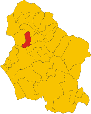
.svg)
Map of comune of Careggine (province of Lucca, region Tuscany, Italy).svg
4,176 × 5,190; 77 KB
4,176 × 5,190; 77 KB
0 references

LU
0 references


24.08 square kilometre
9 October 2011
5 references
Superficie di Comuni Province e Regioni italiane al 9 ottobre 2011 (Italian)
16 March 2019
549
1 January 2017
1 reference
539
1 January 2018
4 references
Popolazione Residente al 1° Gennaio 2018 (Italian)
16 March 2019
Identifiers
398730465
0 references