Grassano (Q296352): Difference between revisions
Jump to navigation
Jump to search
(Changed an Item: Adding this statements since they where added in Wikidata) |
(Changed an Item: Adding this statements since they where added in Wikidata) |
||||||||||||||
| Property / category for people born here | |||||||||||||||
| Property / category for people born here: Q2599889 / rank | |||||||||||||||
Normal rank | |||||||||||||||
| Property / category for people born here: Q2599889 / reference | |||||||||||||||
| Property / category for people who died here | |||||||||||||||
| Property / category for people who died here: Category:Deaths in Grassano / rank | |||||||||||||||
Normal rank | |||||||||||||||
| Property / category for people who died here: Category:Deaths in Grassano / reference | |||||||||||||||
| Property / topic's main category | |||||||||||||||
| Property / topic's main category: Category:Grassano / rank | |||||||||||||||
Normal rank | |||||||||||||||
| Property / topic's main category: Category:Grassano / reference | |||||||||||||||
| Property / elevation above sea level | |||||||||||||||
576±1 metre
| |||||||||||||||
| Property / elevation above sea level: 576±1 metre / rank | |||||||||||||||
Normal rank | |||||||||||||||
| Property / elevation above sea level: 576±1 metre / reference | |||||||||||||||
| Property / official website | |||||||||||||||
| Property / official website: http://www.comune.grassano.mt.it/ / rank | |||||||||||||||
Normal rank | |||||||||||||||
| Property / official website: http://www.comune.grassano.mt.it/ / reference | |||||||||||||||
| Property / licence plate code | |||||||||||||||
MT | |||||||||||||||
| Property / licence plate code: MT / rank | |||||||||||||||
Normal rank | |||||||||||||||
| Property / coordinates of northernmost point | |||||||||||||||
40°40'47.028"N, 16°16'19.099"E
| |||||||||||||||
| Property / coordinates of northernmost point: 40°40'47.028"N, 16°16'19.099"E / rank | |||||||||||||||
Normal rank | |||||||||||||||
| Property / coordinates of northernmost point: 40°40'47.028"N, 16°16'19.099"E / reference | |||||||||||||||
| Property / coordinates of southernmost point | |||||||||||||||
40°35'19.475"N, 16°17'28.262"E
| |||||||||||||||
| Property / coordinates of southernmost point: 40°35'19.475"N, 16°17'28.262"E / rank | |||||||||||||||
Normal rank | |||||||||||||||
| Property / coordinates of southernmost point: 40°35'19.475"N, 16°17'28.262"E / reference | |||||||||||||||
| Property / coordinates of easternmost point | |||||||||||||||
40°38'50.089"N, 16°19'20.716"E
| |||||||||||||||
| Property / coordinates of easternmost point: 40°38'50.089"N, 16°19'20.716"E / rank | |||||||||||||||
Normal rank | |||||||||||||||
| Property / coordinates of easternmost point: 40°38'50.089"N, 16°19'20.716"E / reference | |||||||||||||||
| Property / coordinates of westernmost point | |||||||||||||||
40°38'18.539"N, 16°14'26.189"E
| |||||||||||||||
| Property / coordinates of westernmost point: 40°38'18.539"N, 16°14'26.189"E / rank | |||||||||||||||
Normal rank | |||||||||||||||
| Property / coordinates of westernmost point: 40°38'18.539"N, 16°14'26.189"E / reference | |||||||||||||||
| Property / OSM relation ID | |||||||||||||||
| Property / OSM relation ID: 40616 / rank | |||||||||||||||
Normal rank | |||||||||||||||
| Property / Quora topic ID | |||||||||||||||
| Property / Quora topic ID: Grassano / rank | |||||||||||||||
Normal rank | |||||||||||||||
| Property / Quora topic ID: Grassano / reference | |||||||||||||||
| Property / capital | |||||||||||||||
| Property / capital: Grassano / rank | |||||||||||||||
Normal rank | |||||||||||||||
| Property / area | |||||||||||||||
41.63 square kilometre
| |||||||||||||||
| Property / area: 41.63 square kilometre / rank | |||||||||||||||
Normal rank | |||||||||||||||
| Property / area: 41.63 square kilometre / qualifier | |||||||||||||||
point in time: 9 October 2011
| |||||||||||||||
| Property / area: 41.63 square kilometre / reference | |||||||||||||||
| Property / area: 41.63 square kilometre / reference | |||||||||||||||
| Property / area: 41.63 square kilometre / reference | |||||||||||||||
title: Superficie di Comuni Province e Regioni italiane al 9 ottobre 2011 (Italian) | |||||||||||||||
| Property / area: 41.63 square kilometre / reference | |||||||||||||||
retrieved: 16 March 2019
| |||||||||||||||
| Property / area: 41.63 square kilometre / reference | |||||||||||||||
| Property / population | |||||||||||||||
5,112
| |||||||||||||||
| Property / population: 5,112 / rank | |||||||||||||||
Normal rank | |||||||||||||||
| Property / population: 5,112 / qualifier | |||||||||||||||
point in time: 1 January 2017
| |||||||||||||||
| Property / population: 5,112 / qualifier | |||||||||||||||
| Property / population: 5,112 / reference | |||||||||||||||
| Property / population | |||||||||||||||
5,077
| |||||||||||||||
| Property / population: 5,077 / rank | |||||||||||||||
Preferred rank | |||||||||||||||
| Property / population: 5,077 / qualifier | |||||||||||||||
point in time: 1 January 2018
| |||||||||||||||
| Property / population: 5,077 / qualifier | |||||||||||||||
| Property / population: 5,077 / reference | |||||||||||||||
| Property / population: 5,077 / reference | |||||||||||||||
title: Popolazione Residente al 1° Gennaio 2018 (Italian) | |||||||||||||||
| Property / population: 5,077 / reference | |||||||||||||||
retrieved: 16 March 2019
| |||||||||||||||
| Property / population: 5,077 / reference | |||||||||||||||
| Property / IndicePA ID | |||||||||||||||
| Property / IndicePA ID: c_e147 / rank | |||||||||||||||
Normal rank | |||||||||||||||
| Property / Who's on First ID | |||||||||||||||
| Property / Who's on First ID: 101802043 / rank | |||||||||||||||
Normal rank | |||||||||||||||
| Property / category of associated people | |||||||||||||||
| Property / category of associated people: Category:People of Grassano / rank | |||||||||||||||
Normal rank | |||||||||||||||
| Property / De Agostini ID | |||||||||||||||
| Property / De Agostini ID: Grassano / rank | |||||||||||||||
Normal rank | |||||||||||||||
Revision as of 17:30, 5 August 2020
Italian comune
| Language | Label | Description | Also known as |
|---|---|---|---|
| English | Grassano |
Italian comune |
Statements

Grassano
0 references
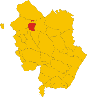
.svg)
Map of comune of Grassano (province of Matera, region Basilicata, Italy).svg
2,355 × 2,616; 92 KB
2,355 × 2,616; 92 KB
1 reference
MT
0 references


41.63 square kilometre
9 October 2011
5 references
Superficie di Comuni Province e Regioni italiane al 9 ottobre 2011 (Italian)
16 March 2019
5,112
1 January 2017
1 reference
5,077
1 January 2018
4 references
Popolazione Residente al 1° Gennaio 2018 (Italian)
16 March 2019
Identifiers
80002540773
0 references