Pietrapaola (Q276450): Difference between revisions
Jump to navigation
Jump to search
(Changed an Item: Adding this statements since they where added in Wikidata) |
(Changed an Item: Adding this statements since they where added in Wikidata) |
||||||||||||||
| Property / Commons category | |||||||||||||||
Pietrapaola | |||||||||||||||
| Property / Commons category: Pietrapaola / rank | |||||||||||||||
Normal rank | |||||||||||||||
| Property / Commons category: Pietrapaola / reference | |||||||||||||||
| Property / Digital Atlas of the Roman Empire ID | |||||||||||||||
| Property / Digital Atlas of the Roman Empire ID: 30450 / rank | |||||||||||||||
Normal rank | |||||||||||||||
| Property / VIAF ID | |||||||||||||||
| Property / VIAF ID: 313476459 / rank | |||||||||||||||
Normal rank | |||||||||||||||
| Property / VIAF ID: 313476459 / reference | |||||||||||||||
| Property / VIAF ID: 313476459 / reference | |||||||||||||||
retrieved: 2 August 2015
| |||||||||||||||
| Property / TGN ID | |||||||||||||||
| Property / TGN ID: 1045994 / rank | |||||||||||||||
Normal rank | |||||||||||||||
| Property / official website | |||||||||||||||
| Property / official website: http://www.comunepietrapaola.it / rank | |||||||||||||||
Normal rank | |||||||||||||||
| Property / official website: http://www.comunepietrapaola.it / reference | |||||||||||||||
| Property / coordinate location | |||||||||||||||
39°29'0"N, 16°49'0"E
| |||||||||||||||
| Property / coordinate location: 39°29'0"N, 16°49'0"E / rank | |||||||||||||||
Normal rank | |||||||||||||||
| Property / coordinate location: 39°29'0"N, 16°49'0"E / reference | |||||||||||||||
| Property / licence plate code | |||||||||||||||
CS | |||||||||||||||
| Property / licence plate code: CS / rank | |||||||||||||||
Normal rank | |||||||||||||||
| Property / OSM relation ID | |||||||||||||||
| Property / OSM relation ID: 39941 / rank | |||||||||||||||
Normal rank | |||||||||||||||
| Property / coordinates of northernmost point | |||||||||||||||
39°33'44.543"N, 16°50'3.044"E
| |||||||||||||||
| Property / coordinates of northernmost point: 39°33'44.543"N, 16°50'3.044"E / rank | |||||||||||||||
Normal rank | |||||||||||||||
| Property / coordinates of northernmost point: 39°33'44.543"N, 16°50'3.044"E / reference | |||||||||||||||
| Property / coordinates of southernmost point | |||||||||||||||
39°26'46.068"N, 16°43'2.777"E
| |||||||||||||||
| Property / coordinates of southernmost point: 39°26'46.068"N, 16°43'2.777"E / rank | |||||||||||||||
Normal rank | |||||||||||||||
| Property / coordinates of southernmost point: 39°26'46.068"N, 16°43'2.777"E / reference | |||||||||||||||
| Property / coordinates of easternmost point | |||||||||||||||
39°32'42.630"N, 16°51'42.908"E
| |||||||||||||||
| Property / coordinates of easternmost point: 39°32'42.630"N, 16°51'42.908"E / rank | |||||||||||||||
Normal rank | |||||||||||||||
| Property / coordinates of easternmost point: 39°32'42.630"N, 16°51'42.908"E / reference | |||||||||||||||
| Property / coordinates of westernmost point | |||||||||||||||
39°27'38.354"N, 16°42'32.346"E
| |||||||||||||||
| Property / coordinates of westernmost point: 39°27'38.354"N, 16°42'32.346"E / rank | |||||||||||||||
Normal rank | |||||||||||||||
| Property / coordinates of westernmost point: 39°27'38.354"N, 16°42'32.346"E / reference | |||||||||||||||
| Property / elevation above sea level | |||||||||||||||
50 metre
| |||||||||||||||
| Property / elevation above sea level: 50 metre / rank | |||||||||||||||
Normal rank | |||||||||||||||
| Property / elevation above sea level: 50 metre / reference | |||||||||||||||
| Property / capital | |||||||||||||||
| Property / capital: Pietrapaola / rank | |||||||||||||||
Normal rank | |||||||||||||||
| Property / area | |||||||||||||||
52.82 square kilometre
| |||||||||||||||
| Property / area: 52.82 square kilometre / rank | |||||||||||||||
Normal rank | |||||||||||||||
| Property / area: 52.82 square kilometre / qualifier | |||||||||||||||
point in time: 9 October 2011
| |||||||||||||||
| Property / area: 52.82 square kilometre / reference | |||||||||||||||
| Property / area: 52.82 square kilometre / reference | |||||||||||||||
| Property / area: 52.82 square kilometre / reference | |||||||||||||||
title: Superficie di Comuni Province e Regioni italiane al 9 ottobre 2011 (Italian) | |||||||||||||||
| Property / area: 52.82 square kilometre / reference | |||||||||||||||
retrieved: 16 March 2019
| |||||||||||||||
| Property / area: 52.82 square kilometre / reference | |||||||||||||||
| Property / population | |||||||||||||||
1,126
| |||||||||||||||
| Property / population: 1,126 / rank | |||||||||||||||
Normal rank | |||||||||||||||
| Property / population: 1,126 / qualifier | |||||||||||||||
point in time: 1 January 2017
| |||||||||||||||
| Property / population: 1,126 / qualifier | |||||||||||||||
| Property / population: 1,126 / reference | |||||||||||||||
| Property / population | |||||||||||||||
1,109
| |||||||||||||||
| Property / population: 1,109 / rank | |||||||||||||||
Preferred rank | |||||||||||||||
| Property / population: 1,109 / qualifier | |||||||||||||||
point in time: 1 January 2018
| |||||||||||||||
| Property / population: 1,109 / qualifier | |||||||||||||||
| Property / population: 1,109 / reference | |||||||||||||||
| Property / population: 1,109 / reference | |||||||||||||||
title: Popolazione Residente al 1° Gennaio 2018 (Italian) | |||||||||||||||
| Property / population: 1,109 / reference | |||||||||||||||
retrieved: 16 March 2019
| |||||||||||||||
| Property / population: 1,109 / reference | |||||||||||||||
| Property / IndicePA ID | |||||||||||||||
| Property / IndicePA ID: c_g622 / rank | |||||||||||||||
Normal rank | |||||||||||||||
| Property / Who's on First ID | |||||||||||||||
| Property / Who's on First ID: 101801657 / rank | |||||||||||||||
Normal rank | |||||||||||||||
| Property / public holiday | |||||||||||||||
| Property / public holiday: patronal festival / rank | |||||||||||||||
Normal rank | |||||||||||||||
| Property / public holiday: patronal festival / qualifier | |||||||||||||||
Revision as of 10:32, 29 July 2020
Italian comune
| Language | Label | Description | Also known as |
|---|---|---|---|
| English | Pietrapaola |
Italian comune |
Statements

87060
0 references
.svg)
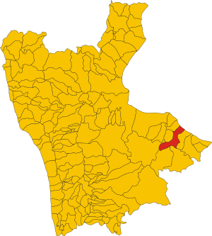
Map of comune of Pietrapaola (province of Cosenza, region Calabria, Italy).svg
2,309 × 2,561; 323 KB
2,309 × 2,561; 323 KB
1 reference
CS
0 references


52.82 square kilometre
9 October 2011
5 references
Superficie di Comuni Province e Regioni italiane al 9 ottobre 2011 (Italian)
16 March 2019
1,126
1 January 2017
1 reference
1,109
1 January 2018
4 references
Popolazione Residente al 1° Gennaio 2018 (Italian)
16 March 2019
Identifiers
87000290780
0 references
2--45785
0 references