Castiglione d'Orcia (Q262900): Difference between revisions
Jump to navigation
Jump to search
(Changed an Item: Adding this statements since they where added in Wikidata) |
(Changed an Item: Adding this statements since they where added in Wikidata) |
||||||||||||||
| Property / instance of | |||||||||||||||
| Property / instance of: commune of Italy / rank | |||||||||||||||
Normal rank | |||||||||||||||
| Property / Freebase ID | |||||||||||||||
| Property / Freebase ID: /m/0gm0pg / rank | |||||||||||||||
Normal rank | |||||||||||||||
| Property / Freebase ID: /m/0gm0pg / reference | |||||||||||||||
| Property / Freebase ID: /m/0gm0pg / reference | |||||||||||||||
publication date: 28 October 2013
| |||||||||||||||
| Property / GeoNames ID | |||||||||||||||
| Property / GeoNames ID: 6538597 / rank | |||||||||||||||
Normal rank | |||||||||||||||
| Property / GeoNames ID: 6538597 / reference | |||||||||||||||
| Property / category for people born here | |||||||||||||||
| Property / category for people born here: Q2578290 / rank | |||||||||||||||
Normal rank | |||||||||||||||
| Property / category for people born here: Q2578290 / reference | |||||||||||||||
| Property / official website | |||||||||||||||
| Property / official website: http://www.comune.castiglionedorcia.siena.it/ / rank | |||||||||||||||
Normal rank | |||||||||||||||
| Property / VIAF ID | |||||||||||||||
| Property / VIAF ID: 133886032 / rank | |||||||||||||||
Normal rank | |||||||||||||||
| Property / VIAF ID: 133886032 / reference | |||||||||||||||
| Property / VIAF ID: 133886032 / reference | |||||||||||||||
retrieved: 2 August 2015
| |||||||||||||||
| Property / elevation above sea level | |||||||||||||||
540±1 metre
| |||||||||||||||
| Property / elevation above sea level: 540±1 metre / rank | |||||||||||||||
Normal rank | |||||||||||||||
| Property / elevation above sea level: 540±1 metre / reference | |||||||||||||||
| Property / TGN ID | |||||||||||||||
| Property / TGN ID: 7007728 / rank | |||||||||||||||
Normal rank | |||||||||||||||
| Property / licence plate code | |||||||||||||||
SI | |||||||||||||||
| Property / licence plate code: SI / rank | |||||||||||||||
Normal rank | |||||||||||||||
| Property / coordinates of northernmost point | |||||||||||||||
43°2'35.912"N, 11°33'35.669"E
| |||||||||||||||
| Property / coordinates of northernmost point: 43°2'35.912"N, 11°33'35.669"E / rank | |||||||||||||||
Normal rank | |||||||||||||||
| Property / coordinates of northernmost point: 43°2'35.912"N, 11°33'35.669"E / reference | |||||||||||||||
| Property / coordinates of southernmost point | |||||||||||||||
42°54'33.062"N, 11°38'3.260"E
| |||||||||||||||
| Property / coordinates of southernmost point: 42°54'33.062"N, 11°38'3.260"E / rank | |||||||||||||||
Normal rank | |||||||||||||||
| Property / coordinates of southernmost point: 42°54'33.062"N, 11°38'3.260"E / reference | |||||||||||||||
| Property / coordinates of easternmost point | |||||||||||||||
43°1'2.057"N, 11°43'58.228"E
| |||||||||||||||
| Property / coordinates of easternmost point: 43°1'2.057"N, 11°43'58.228"E / rank | |||||||||||||||
Normal rank | |||||||||||||||
| Property / coordinates of easternmost point: 43°1'2.057"N, 11°43'58.228"E / reference | |||||||||||||||
| Property / coordinates of westernmost point | |||||||||||||||
42°58'3.979"N, 11°31'34.424"E
| |||||||||||||||
| Property / coordinates of westernmost point: 42°58'3.979"N, 11°31'34.424"E / rank | |||||||||||||||
Normal rank | |||||||||||||||
| Property / coordinates of westernmost point: 42°58'3.979"N, 11°31'34.424"E / reference | |||||||||||||||
| Property / OSM relation ID | |||||||||||||||
| Property / OSM relation ID: 42237 / rank | |||||||||||||||
Normal rank | |||||||||||||||
| Property / capital | |||||||||||||||
| Property / capital: Castiglione d'Orcia / rank | |||||||||||||||
Normal rank | |||||||||||||||
| Property / area | |||||||||||||||
141.66 square kilometre
| |||||||||||||||
| Property / area: 141.66 square kilometre / rank | |||||||||||||||
Normal rank | |||||||||||||||
| Property / area: 141.66 square kilometre / qualifier | |||||||||||||||
point in time: 9 October 2011
| |||||||||||||||
| Property / area: 141.66 square kilometre / reference | |||||||||||||||
| Property / area: 141.66 square kilometre / reference | |||||||||||||||
| Property / area: 141.66 square kilometre / reference | |||||||||||||||
title: Superficie di Comuni Province e Regioni italiane al 9 ottobre 2011 (Italian) | |||||||||||||||
| Property / area: 141.66 square kilometre / reference | |||||||||||||||
retrieved: 16 March 2019
| |||||||||||||||
| Property / area: 141.66 square kilometre / reference | |||||||||||||||
| Property / population | |||||||||||||||
2,323
| |||||||||||||||
| Property / population: 2,323 / rank | |||||||||||||||
Normal rank | |||||||||||||||
| Property / population: 2,323 / qualifier | |||||||||||||||
point in time: 1 January 2017
| |||||||||||||||
| Property / population: 2,323 / qualifier | |||||||||||||||
| Property / population: 2,323 / reference | |||||||||||||||
| Property / population | |||||||||||||||
2,294
| |||||||||||||||
| Property / population: 2,294 / rank | |||||||||||||||
Preferred rank | |||||||||||||||
| Property / population: 2,294 / qualifier | |||||||||||||||
point in time: 1 January 2018
| |||||||||||||||
| Property / population: 2,294 / qualifier | |||||||||||||||
| Property / population: 2,294 / reference | |||||||||||||||
| Property / population: 2,294 / reference | |||||||||||||||
title: Popolazione Residente al 1° Gennaio 2018 (Italian) | |||||||||||||||
| Property / population: 2,294 / reference | |||||||||||||||
retrieved: 16 March 2019
| |||||||||||||||
| Property / population: 2,294 / reference | |||||||||||||||
| Property / UN/LOCODE | |||||||||||||||
| Property / UN/LOCODE: ITCG5 / rank | |||||||||||||||
Normal rank | |||||||||||||||
| Property / page banner | |||||||||||||||
| Property / page banner: Castiglionedorcia-countryside.jpg / rank | |||||||||||||||
Normal rank | |||||||||||||||
Revision as of 13:38, 28 July 2020
Italian comune
| Language | Label | Description | Also known as |
|---|---|---|---|
| English | Castiglione d'Orcia |
Italian comune |
Statements

Castiglione d'Orcia
0 references
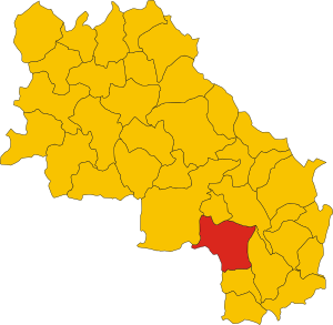
.svg)
Map of comune of Castiglione d'Orcia (province of Siena, region Tuscany, Italy).svg
3,778 × 3,688; 105 KB
3,778 × 3,688; 105 KB
1 reference

SI
0 references


141.66 square kilometre
9 October 2011
5 references
Superficie di Comuni Province e Regioni italiane al 9 ottobre 2011 (Italian)
16 March 2019
2,323
1 January 2017
1 reference
2,294
1 January 2018
4 references
Popolazione Residente al 1° Gennaio 2018 (Italian)
16 March 2019
Identifiers
240610527
0 references