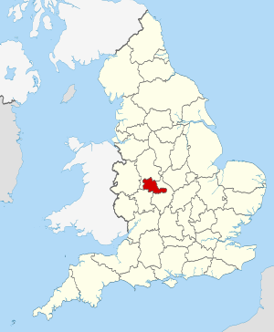
West Midlands (Q2549930): Difference between revisions
Jump to navigation
Jump to search
(Changed an Item: Adding this statements since they where added in Wikidata) |
(Changed an Item: Adding this statements since they where added in Wikidata) |
||||||||||||||
| Property / flag image | |||||||||||||||
| Property / flag image: Flag of the West Midlands County.svg / rank | |||||||||||||||
Normal rank | |||||||||||||||
| Property / flag image: Flag of the West Midlands County.svg / reference | |||||||||||||||
| Property / GSS code (2011) | |||||||||||||||
| Property / GSS code (2011): E11000005 / rank | |||||||||||||||
Normal rank | |||||||||||||||
| Property / GSS code (2011): E11000005 / reference | |||||||||||||||
retrieved: 14 March 2017
| |||||||||||||||
| Property / locator map image | |||||||||||||||
| Property / locator map image: West Midlands UK locator map 2010.svg / rank | |||||||||||||||
Normal rank | |||||||||||||||
| Property / area | |||||||||||||||
901.6396 square kilometre
| |||||||||||||||
| Property / area: 901.6396 square kilometre / rank | |||||||||||||||
Normal rank | |||||||||||||||
| Property / area: 901.6396 square kilometre / qualifier | |||||||||||||||
point in time: 2016
| |||||||||||||||
| Property / area: 901.6396 square kilometre / reference | |||||||||||||||
| Property / Commons gallery | |||||||||||||||
West Midlands | |||||||||||||||
| Property / Commons gallery: West Midlands / rank | |||||||||||||||
Normal rank | |||||||||||||||
| Property / part of | |||||||||||||||
| Property / part of: West Midlands / rank | |||||||||||||||
Normal rank | |||||||||||||||
| Property / part of: West Midlands / reference | |||||||||||||||
| Property / archINFORM location ID | |||||||||||||||
| Property / archINFORM location ID: 6595 / rank | |||||||||||||||
Normal rank | |||||||||||||||
| Property / archINFORM location ID: 6595 / reference | |||||||||||||||
| Property / archINFORM location ID: 6595 / reference | |||||||||||||||
| Property / archINFORM location ID: 6595 / reference | |||||||||||||||
retrieved: 5 August 2018
| |||||||||||||||
| Property / contains administrative territorial entity | |||||||||||||||
| Property / contains administrative territorial entity: Birmingham / rank | |||||||||||||||
Normal rank | |||||||||||||||
| Property / contains administrative territorial entity | |||||||||||||||
| Property / contains administrative territorial entity: Coventry / rank | |||||||||||||||
Normal rank | |||||||||||||||
| Property / contains administrative territorial entity | |||||||||||||||
| Property / contains administrative territorial entity: Dudley / rank | |||||||||||||||
Normal rank | |||||||||||||||
| Property / contains administrative territorial entity | |||||||||||||||
| Property / contains administrative territorial entity: Sandwell / rank | |||||||||||||||
Normal rank | |||||||||||||||
| Property / contains administrative territorial entity | |||||||||||||||
| Property / contains administrative territorial entity: Solihull / rank | |||||||||||||||
Normal rank | |||||||||||||||
| Property / contains administrative territorial entity | |||||||||||||||
| Property / contains administrative territorial entity: Walsall / rank | |||||||||||||||
Normal rank | |||||||||||||||
| Property / contains administrative territorial entity | |||||||||||||||
| Property / contains administrative territorial entity: Wolverhampton / rank | |||||||||||||||
Normal rank | |||||||||||||||
| Property / TGN ID | |||||||||||||||
| Property / TGN ID: 7029506 / rank | |||||||||||||||
Normal rank | |||||||||||||||
| Property / shares border with | |||||||||||||||
| Property / shares border with: Staffordshire / rank | |||||||||||||||
Normal rank | |||||||||||||||
| Property / shares border with | |||||||||||||||
| Property / shares border with: Warwickshire / rank | |||||||||||||||
Normal rank | |||||||||||||||
| Property / shares border with | |||||||||||||||
| Property / shares border with: Worcestershire / rank | |||||||||||||||
Normal rank | |||||||||||||||
| Property / Gran Enciclopèdia Catalana ID | |||||||||||||||
| Property / Gran Enciclopèdia Catalana ID: 0072073 / rank | |||||||||||||||
Normal rank | |||||||||||||||
| Property / population | |||||||||||||||
2,916,458
| |||||||||||||||
| Property / population: 2,916,458 / rank | |||||||||||||||
Normal rank | |||||||||||||||
| Property / population: 2,916,458 / qualifier | |||||||||||||||
point in time: 2018
| |||||||||||||||
| Property / population: 2,916,458 / qualifier | |||||||||||||||
| Property / population: 2,916,458 / reference | |||||||||||||||
Revision as of 22:43, 2 July 2020
metropolitan county in England
- West Midlands county
| Language | Label | Description | Also known as |
|---|---|---|---|
| English | West Midlands |
metropolitan county in England |
|
Statements
3 references
901.6396 square kilometre
2016
West Midlands
0 references
Identifiers
3 references


