Dorset (Q2549306): Difference between revisions
Jump to navigation
Jump to search
(Changed an Item: Adding this statements since they where added in Wikidata) |
(Changed an Item: Adding this statements since they where added in Wikidata) |
||||||||||||||
| Property / VIAF ID | |||||||||||||||
| Property / VIAF ID: 182620392 / rank | |||||||||||||||
Normal rank | |||||||||||||||
| Property / VIAF ID: 182620392 / reference | |||||||||||||||
| Property / NUTS code | |||||||||||||||
| Property / NUTS code: UKK22 / rank | |||||||||||||||
Normal rank | |||||||||||||||
| Property / NUTS code: UKK22 / qualifier | |||||||||||||||
start time: 1 January 1999
| |||||||||||||||
| Property / Library of Congress authority ID | |||||||||||||||
| Property / Library of Congress authority ID: n81020291 / rank | |||||||||||||||
Normal rank | |||||||||||||||
| Property / Library of Congress authority ID: n81020291 / reference | |||||||||||||||
| Property / contains administrative territorial entity | |||||||||||||||
| Property / contains administrative territorial entity: Dorset / rank | |||||||||||||||
Normal rank | |||||||||||||||
| Property / contains administrative territorial entity | |||||||||||||||
| Property / contains administrative territorial entity: Bournemouth, Christchurch and Poole Council / rank | |||||||||||||||
Normal rank | |||||||||||||||
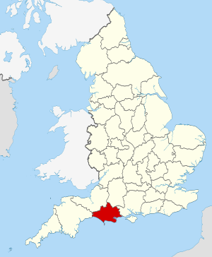
| Property / locator map image | |||||||||||||||
| Property / locator map image: Dorset UK locator map 2010.svg / rank | |||||||||||||||
Normal rank | |||||||||||||||
| Property / shares border with | |||||||||||||||
| Property / shares border with: Somerset / rank | |||||||||||||||
Normal rank | |||||||||||||||
| Property / shares border with: Somerset / reference | |||||||||||||||
| Property / shares border with | |||||||||||||||
| Property / shares border with: Devon / rank | |||||||||||||||
Normal rank | |||||||||||||||
| Property / shares border with: Devon / reference | |||||||||||||||
| Property / shares border with | |||||||||||||||
| Property / shares border with: Wiltshire / rank | |||||||||||||||
Normal rank | |||||||||||||||
| Property / shares border with: Wiltshire / reference | |||||||||||||||
| Property / shares border with | |||||||||||||||
| Property / shares border with: Hampshire / rank | |||||||||||||||
Normal rank | |||||||||||||||
| Property / shares border with: Hampshire / reference | |||||||||||||||
| Property / geography of topic | |||||||||||||||
| Property / geography of topic: geography of Dorset / rank | |||||||||||||||
Normal rank | |||||||||||||||
| Property / Wikidata usage instructions | |||||||||||||||
use this item for the ceremonial county; Q55231693 for the district; and Q67479793 for the historic county. (English) | |||||||||||||||
| Property / Wikidata usage instructions: use this item for the ceremonial county; Q55231693 for the district; and Q67479793 for the historic county. (English) / rank | |||||||||||||||
Normal rank | |||||||||||||||
| Property / DMOZ ID | |||||||||||||||
| Property / DMOZ ID: Regional/Europe/United_Kingdom/England/Dorset/ / rank | |||||||||||||||
Normal rank | |||||||||||||||
| Property / official website | |||||||||||||||
| Property / official website: https://www.dorsetforyou.gov.uk/ / rank | |||||||||||||||
Normal rank | |||||||||||||||
| Property / TGN ID | |||||||||||||||
| Property / TGN ID: 7011961 / rank | |||||||||||||||
Normal rank | |||||||||||||||
| Property / Vision of Britain place ID | |||||||||||||||
| Property / Vision of Britain place ID: 17439 / rank | |||||||||||||||
Normal rank | |||||||||||||||
| Property / Vision of Britain place ID: 17439 / qualifier | |||||||||||||||
named as: Dorset, England | |||||||||||||||
| Property / Vision of Britain place ID: 17439 / reference | |||||||||||||||
retrieved: 1 March 2017
| |||||||||||||||
| Property / area | |||||||||||||||
2,813.998 square kilometre
| |||||||||||||||
| Property / area: 2,813.998 square kilometre / rank | |||||||||||||||
Normal rank | |||||||||||||||
| Property / area: 2,813.998 square kilometre / qualifier | |||||||||||||||
point in time: 2016
| |||||||||||||||
| Property / area: 2,813.998 square kilometre / reference | |||||||||||||||
| Property / US National Archives Identifier | |||||||||||||||
| Property / US National Archives Identifier: 10045680 / rank | |||||||||||||||
Normal rank | |||||||||||||||
| Property / category of people buried here | |||||||||||||||
| Property / category of people buried here: Category:Burials in Dorset / rank | |||||||||||||||
Normal rank | |||||||||||||||
| Property / archINFORM location ID | |||||||||||||||
| Property / archINFORM location ID: 2385 / rank | |||||||||||||||
Normal rank | |||||||||||||||
| Property / archINFORM location ID: 2385 / reference | |||||||||||||||
| Property / archINFORM location ID: 2385 / reference | |||||||||||||||
| Property / archINFORM location ID: 2385 / reference | |||||||||||||||
retrieved: 5 August 2018
| |||||||||||||||
Revision as of 20:36, 2 July 2020
ceremonial county in South West England, UK
- Dorsetshire
| Language | Label | Description | Also known as |
|---|---|---|---|
| English | Dorset |
ceremonial county in South West England, UK |
|
Statements
Dorset
0 references
use this item for the ceremonial county; Q55231693 for the district; and Q67479793 for the historic county. (English)
0 references
2,813.998 square kilometre
2016
Identifiers
UKD6
5 references
30 December 2013
List of FIPS region codes (S-U) (English)
3 references


