Worcestershire (Q2549411): Difference between revisions
Jump to navigation
Jump to search
(Changed an Item: Adding these statements since they where added in Wikidata) |
(Changed an Item: Adding these statements since they where added in Wikidata) |
||||||||||||||
| (12 intermediate revisions by the same user not shown) | |||||||||||||||
| description / sv | description / sv | ||||||||||||||
grevskap i mellersta England, Storbritannien | |||||||||||||||
| Property / Encyclopædia Britannica Online ID | |||||||||||||||
| Property / Encyclopædia Britannica Online ID: place/Worcestershire-county-England / rank | |||||||||||||||
| Property / NKCR AUT ID | |||||||||||||||
| Property / NKCR AUT ID: ge765356 / rank | |||||||||||||||
| Property / legislative body | |||||||||||||||
| Property / legislative body: Worcestershire County Council / rank | |||||||||||||||
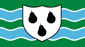
| Property / flag | |||||||||||||||
| Property / flag: N/A / rank | |||||||||||||||
| Property / population | |||||||||||||||
| |||||||||||||||
| Property / population: 598,070 / rank | |||||||||||||||
| Property / population: 598,070 / qualifier | |||||||||||||||
| |||||||||||||||
| Property / population: 598,070 / qualifier | |||||||||||||||
| Property / population: 598,070 / reference | |||||||||||||||
| Property / described by source | |||||||||||||||
| Property / described by source: Encyclopædia Britannica 11th edition / rank | |||||||||||||||
Normal rank | |||||||||||||||
| Property / described by source: Encyclopædia Britannica 11th edition / qualifier | |||||||||||||||
| Property / population | |||||||||||||||
569,000
| |||||||||||||||
| Property / population: 569,000 / rank | |||||||||||||||
Normal rank | |||||||||||||||
| Property / population: 569,000 / qualifier | |||||||||||||||
point in time: 2012
| |||||||||||||||
| Property / population: 569,000 / qualifier | |||||||||||||||
| Property / population: 569,000 / reference | |||||||||||||||
| Property / population | |||||||||||||||
598,070
| |||||||||||||||
| Property / population: 598,070 / rank | |||||||||||||||
Normal rank | |||||||||||||||
| Property / population: 598,070 / qualifier | |||||||||||||||
point in time: 2020
| |||||||||||||||
| Property / population: 598,070 / qualifier | |||||||||||||||
| Property / population: 598,070 / reference | |||||||||||||||
| Property / population | |||||||||||||||
609,216
| |||||||||||||||
| Property / population: 609,216 / rank | |||||||||||||||
Preferred rank | |||||||||||||||
| Property / population: 609,216 / qualifier | |||||||||||||||
point in time: 2022
| |||||||||||||||
| Property / population: 609,216 / qualifier | |||||||||||||||
| Property / population: 609,216 / reference | |||||||||||||||
| Property / NKCR AUT ID | |||||||||||||||
| Property / NKCR AUT ID: ge765356 / rank | |||||||||||||||
Normal rank | |||||||||||||||
| Property / NKCR AUT ID: ge765356 / qualifier | |||||||||||||||
named as: Worcestershire (Anglie : hrabství) | |||||||||||||||
| Property / museum-digital place ID | |||||||||||||||
49696 | |||||||||||||||
| Property / museum-digital place ID: 49696 / rank | |||||||||||||||
Normal rank | |||||||||||||||
| Property / Encyclopædia Britannica Online ID | |||||||||||||||
| Property / Encyclopædia Britannica Online ID: place/Worcestershire-county-England / rank | |||||||||||||||
Normal rank | |||||||||||||||
| Property / Encyclopædia Britannica Online ID: place/Worcestershire-county-England / qualifier | |||||||||||||||
named as: Worcestershire | |||||||||||||||
| Property / native label | |||||||||||||||
Worcestershire (English) | |||||||||||||||
| Property / native label: Worcestershire (English) / rank | |||||||||||||||
Normal rank | |||||||||||||||
| Property / native label: Worcestershire (English) / reference | |||||||||||||||
| Property / native label: Worcestershire (English) / reference | |||||||||||||||
| Property / legislative body | |||||||||||||||
| Property / legislative body: council of Worcestershire County Council / rank | |||||||||||||||
Normal rank | |||||||||||||||
| Property / authority | |||||||||||||||
| Property / authority: Worcestershire County Council / rank | |||||||||||||||
Normal rank | |||||||||||||||
| Property / flag | |||||||||||||||
| Property / flag: flag of Worcestershire / rank | |||||||||||||||
Normal rank | |||||||||||||||
| Property / SNARC ID | |||||||||||||||
Q9618 | |||||||||||||||
| Property / SNARC ID: Q9618 / rank | |||||||||||||||
Normal rank | |||||||||||||||
| Property / LNB ID | |||||||||||||||
| Property / LNB ID: 000350538 / rank | |||||||||||||||
Normal rank | |||||||||||||||
Latest revision as of 12:39, 13 September 2024
non-metropolitan county in the West Midlands of England
- Worcs
- Wigorn
| Language | Label | Description | Also known as |
|---|---|---|---|
| English | Worcestershire |
non-metropolitan county in the West Midlands of England |
|
Statements
3 references
Worcestershire
0 references
April 1994
0 references
1,740.5141 square kilometre
2016
0 references
592,057
3 references
Estimates of the population for the UK, England and Wales, Scotland and Northern Ireland (English)
569,000
598,070
Worcestershire (English)
Identifiers
UKQ4
5 references
30 December 2013
List of FIPS region codes (S-U) (English)
7000000000002993
0 references
3 references
GB.WC
0 references
70537
0 references
3 references
987007548159705171
0 references
Worcestershire
0 references
Q2549411
0 references
49696
0 references
Q9618
0 references


