Solihull (Q2549940): Difference between revisions
Jump to navigation
Jump to search
(Changed an Item: Adding this statements since they where added in Wikidata) |
(Changed an Item: Adding these statements since they where added in Wikidata) |
||||||||||||||
| (22 intermediate revisions by 2 users not shown) | |||||||||||||||
| label / ga | label / ga | ||||||||||||||
Solihull | |||||||||||||||
| description / sv | description / sv | ||||||||||||||
storstadsdistrikt | storstadsdistrikt i England, Storbritannien | ||||||||||||||
| description / da | description / da | ||||||||||||||
2016 NUTS-3-statistische territoriale entiteit | |||||||||||||||
| description / ga | description / ga | ||||||||||||||
ceantar i ngar do Birmingham, Sasana | |||||||||||||||
| description / fr | description / fr | ||||||||||||||
district dans les Midlands de l'Ouest, Angleterre | |||||||||||||||
| Property / coordinate location | |||||||||||||||
| |||||||||||||||
| Property / coordinate location: 52°25'14.99"N, 1°46'36.01"W / rank | |||||||||||||||
| Property / coordinate location: 52°25'14.99"N, 1°46'36.01"W / reference | |||||||||||||||
| Property / located in the administrative territorial entity | |||||||||||||||
| Property / located in the administrative territorial entity: West Midlands / rank | |||||||||||||||
| Property / located in the administrative territorial entity: West Midlands / reference | |||||||||||||||
| Property / population | |||||||||||||||
| |||||||||||||||
| Property / population: 210,400 / rank | |||||||||||||||
| Property / population: 210,400 / qualifier | |||||||||||||||
| |||||||||||||||
| Property / population: 210,400 / qualifier | |||||||||||||||
| Property / population: 210,400 / reference | |||||||||||||||
| Property / instance of | |||||||||||||||
| Property / instance of: 2016 NUTS 3 statistical territorial entity / rank | |||||||||||||||
Normal rank | |||||||||||||||
| Property / instance of | |||||||||||||||
| Property / instance of: 2021 NUTS 3 statistical territorial entity / rank | |||||||||||||||
Preferred rank | |||||||||||||||
| Property / population | |||||||||||||||
206,674
| |||||||||||||||
| Property / population: 206,674 / rank | |||||||||||||||
Normal rank | |||||||||||||||
| Property / population: 206,674 / qualifier | |||||||||||||||
point in time: 2011
| |||||||||||||||
| Property / population: 206,674 / qualifier | |||||||||||||||
| Property / population: 206,674 / reference | |||||||||||||||
| Property / population | |||||||||||||||
210,400
| |||||||||||||||
| Property / population: 210,400 / rank | |||||||||||||||
Normal rank | |||||||||||||||
| Property / population: 210,400 / qualifier | |||||||||||||||
point in time: 2015
| |||||||||||||||
| Property / population: 210,400 / qualifier | |||||||||||||||
| Property / population: 210,400 / reference | |||||||||||||||
| Property / population | |||||||||||||||
214,909
| |||||||||||||||
| Property / population: 214,909 / rank | |||||||||||||||
Preferred rank | |||||||||||||||
| Property / population: 214,909 / qualifier | |||||||||||||||
point in time: 2018
| |||||||||||||||
| Property / population: 214,909 / qualifier | |||||||||||||||
| Property / population: 214,909 / reference | |||||||||||||||
| Property / population | |||||||||||||||
216,240
| |||||||||||||||
| Property / population: 216,240 / rank | |||||||||||||||
Normal rank | |||||||||||||||
| Property / population: 216,240 / qualifier | |||||||||||||||
| Property / population: 216,240 / qualifier | |||||||||||||||
point in time: 2021
| |||||||||||||||
| Property / population: 216,240 / reference | |||||||||||||||
| Property / population | |||||||||||||||
207,400
| |||||||||||||||
| Property / population: 207,400 / rank | |||||||||||||||
Normal rank | |||||||||||||||
| Property / population: 207,400 / qualifier | |||||||||||||||
point in time: 2012
| |||||||||||||||
| Property / population: 207,400 / qualifier | |||||||||||||||
| Property / population: 207,400 / reference | |||||||||||||||
| Property / population | |||||||||||||||
217,678
| |||||||||||||||
| Property / population: 217,678 / rank | |||||||||||||||
Normal rank | |||||||||||||||
| Property / population: 217,678 / qualifier | |||||||||||||||
point in time: 2022
| |||||||||||||||
| Property / population: 217,678 / qualifier | |||||||||||||||
| Property / population: 217,678 / reference | |||||||||||||||
| Property / area | |||||||||||||||
178.2821 square kilometre
| |||||||||||||||
| Property / area: 178.2821 square kilometre / rank | |||||||||||||||
Normal rank | |||||||||||||||
| Property / area: 178.2821 square kilometre / qualifier | |||||||||||||||
point in time: 2016
| |||||||||||||||
| Property / area: 178.2821 square kilometre / reference | |||||||||||||||
| Property / number of households | |||||||||||||||
88,250
| |||||||||||||||
| Property / number of households: 88,250 / rank | |||||||||||||||
Normal rank | |||||||||||||||
| Property / number of households: 88,250 / qualifier | |||||||||||||||
point in time: 2011
| |||||||||||||||
| Property / number of households: 88,250 / qualifier | |||||||||||||||
| Property / number of households: 88,250 / reference | |||||||||||||||
| Property / mean age | |||||||||||||||
41.3 annum
| |||||||||||||||
| Property / mean age: 41.3 annum / rank | |||||||||||||||
Normal rank | |||||||||||||||
| Property / mean age: 41.3 annum / qualifier | |||||||||||||||
point in time: 2011
| |||||||||||||||
| Property / mean age: 41.3 annum / qualifier | |||||||||||||||
| Property / mean age: 41.3 annum / reference | |||||||||||||||
| Property / official name | |||||||||||||||
Solihull (English) | |||||||||||||||
| Property / official name: Solihull (English) / rank | |||||||||||||||
Normal rank | |||||||||||||||
| Property / official name: Solihull (English) / reference | |||||||||||||||
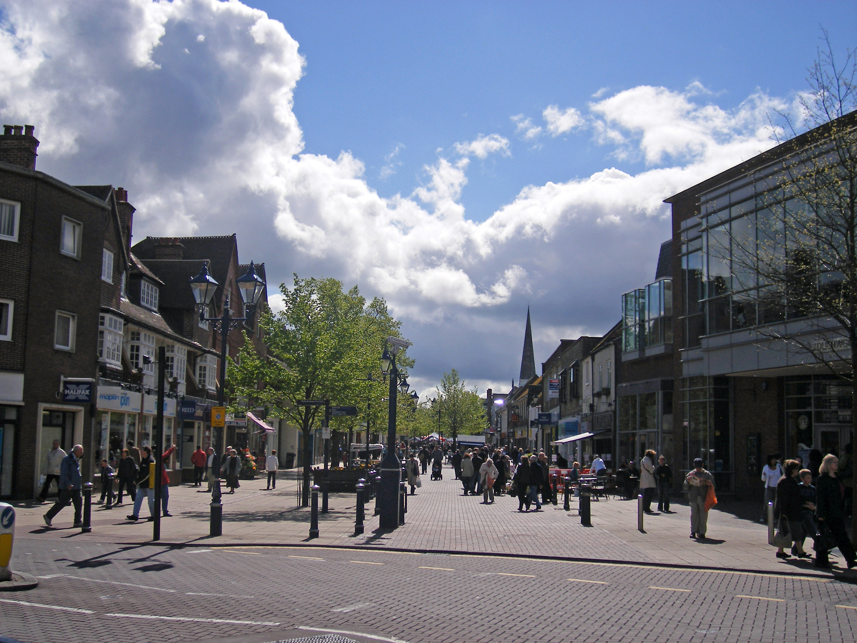
| Property / image | |||||||||||||||
| Property / image: A look up High Street in Solihull.jpg / rank | |||||||||||||||
Normal rank | |||||||||||||||
| Property / image: A look up High Street in Solihull.jpg / qualifier | |||||||||||||||
| Property / image: A look up High Street in Solihull.jpg / qualifier | |||||||||||||||
point in time: 25 April 2009
| |||||||||||||||
| Property / geoshape | |||||||||||||||
| Property / geoshape: Data:Solihull.map / rank | |||||||||||||||
Normal rank | |||||||||||||||
| Property / Who's on First ID | |||||||||||||||
| Property / Who's on First ID: 85684267 / rank | |||||||||||||||
Normal rank | |||||||||||||||
| Property / contained in NUTS | |||||||||||||||
| Property / contained in NUTS: West Midlands / rank | |||||||||||||||
Normal rank | |||||||||||||||
| Property / HASC | |||||||||||||||
GB.SI | |||||||||||||||
| Property / HASC: GB.SI / rank | |||||||||||||||
Normal rank | |||||||||||||||
| Property / BBC News topic ID | |||||||||||||||
| Property / BBC News topic ID: c4y268p9085t / rank | |||||||||||||||
Normal rank | |||||||||||||||
| Property / UK Parliament thesaurus ID | |||||||||||||||
| Property / UK Parliament thesaurus ID: 12876 / rank | |||||||||||||||
Normal rank | |||||||||||||||
| Property / UK Parliament thesaurus ID: 12876 / qualifier | |||||||||||||||
named as: Solihull | |||||||||||||||
| Property / coat of arms image | |||||||||||||||
| Property / coat of arms image: Coat of arms of Solihull Metropolitan Borough Council.png / rank | |||||||||||||||
Normal rank | |||||||||||||||
| Property / coat of arms image: Coat of arms of Solihull Metropolitan Borough Council.png / reference | |||||||||||||||
| Property / official website | |||||||||||||||
| Property / official website: https://www.solihull.gov.uk/ / rank | |||||||||||||||
Normal rank | |||||||||||||||
| Property / legislative body | |||||||||||||||
| Property / legislative body: council of Solihull Metropolitan Borough Council / rank | |||||||||||||||
Normal rank | |||||||||||||||
| Property / EU Knowledge Graph item ID | |||||||||||||||
Q2549940 | |||||||||||||||
| Property / EU Knowledge Graph item ID: Q2549940 / rank | |||||||||||||||
Normal rank | |||||||||||||||
| Property / authority | |||||||||||||||
| Property / authority: Solihull Metropolitan Borough Council / rank | |||||||||||||||
Normal rank | |||||||||||||||
| Property / located in the administrative territorial entity | |||||||||||||||
| Property / located in the administrative territorial entity: West Midlands / rank | |||||||||||||||
Normal rank | |||||||||||||||
| Property / located in the administrative territorial entity: West Midlands / reference | |||||||||||||||
| Property / Encyclopædia Britannica Online ID | |||||||||||||||
| Property / Encyclopædia Britannica Online ID: place/Solihull / rank | |||||||||||||||
Normal rank | |||||||||||||||
| Property / Encyclopædia Britannica Online ID: place/Solihull / qualifier | |||||||||||||||
named as: Solihull | |||||||||||||||
| Property / GNS Unique Feature ID | |||||||||||||||
6077637 | |||||||||||||||
| Property / GNS Unique Feature ID: 6077637 / rank | |||||||||||||||
Normal rank | |||||||||||||||
| Property / coordinate location | |||||||||||||||
52°25'15"N, 1°46'36"W
| |||||||||||||||
| Property / coordinate location: 52°25'15"N, 1°46'36"W / rank | |||||||||||||||
Normal rank | |||||||||||||||
| Property / coordinate location: 52°25'15"N, 1°46'36"W / reference | |||||||||||||||
| links / dewiki / name | links / dewiki / name | ||||||||||||||
| links / enwiki / name | links / enwiki / name | ||||||||||||||
| links / frwiki / name | links / frwiki / name | ||||||||||||||
| links / itwiki / name | links / itwiki / name | ||||||||||||||
| links / nlwiki / name | links / nlwiki / name | ||||||||||||||
| links / plwiki / name | links / plwiki / name | ||||||||||||||
| links / svwiki / name | links / svwiki / name | ||||||||||||||
Latest revision as of 17:33, 11 September 2024
district in the West Midlands, England
- Metropolitan Borough of Solihull
| Language | Label | Description | Also known as |
|---|---|---|---|
| English | Solihull |
district in the West Midlands, England |
|
Statements
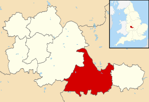
Solihull UK locator map.svg
1,425 × 974; 720 KB
1,425 × 974; 720 KB
Emplacement du district de Solihull dans le comté des West Midlands (French)
1 reference
EnglandSolihull.png
200 × 247; 31 KB
200 × 247; 31 KB
Localisation du district métropolitain de Solihull. (French)
0 references
206,674
210,400
214,909
216,240
1 reference
207,400
178.2821 square kilometre
2016
Solihull (English)
Identifiers
UKM2
5 references
30 December 2013
List of FIPS region codes (S-U) (English)
7000000000000009
0 references
GB.SI
0 references
Q2549940
0 references
6077637
0 references


