Careggine (Q290895): Difference between revisions
Jump to navigation
Jump to search
(Changed an Item) |
(Changed an Item: Adding these statements since they where added in Wikidata) |
||||||||||||||
| (24 intermediate revisions by 2 users not shown) | |||||||||||||||
| label / it | label / it | ||||||||||||||
CAREGGINE | |||||||||||||||
| label / bg | label / bg | ||||||||||||||
Кареджине | |||||||||||||||
| label / de | label / de | ||||||||||||||
Careggine | |||||||||||||||
| label / en | label / en | ||||||||||||||
Careggine | |||||||||||||||
| label / es | label / es | ||||||||||||||
Careggine | |||||||||||||||
| label / fr | label / fr | ||||||||||||||
Careggine | |||||||||||||||
| label / nl | label / nl | ||||||||||||||
Careggine | |||||||||||||||
| label / pl | label / pl | ||||||||||||||
Careggine | |||||||||||||||
| label / pt | label / pt | ||||||||||||||
Careggine | |||||||||||||||
| label / ro | label / ro | ||||||||||||||
Careggine | |||||||||||||||
| label / hu | label / hu | ||||||||||||||
Careggine | |||||||||||||||
| label / sv | label / sv | ||||||||||||||
Careggine | |||||||||||||||
| label / ga | label / ga | ||||||||||||||
Careggine | |||||||||||||||
| label / tr | label / tr | ||||||||||||||
Careggine | |||||||||||||||
| label / el | label / el | ||||||||||||||
Καρέτζινε | |||||||||||||||
| description / en | description / en | ||||||||||||||
Italian comune | |||||||||||||||
| description / it | description / it | ||||||||||||||
comune italiano | |||||||||||||||
| description / bg | description / bg | ||||||||||||||
италианска община | |||||||||||||||
| description / cs | description / cs | ||||||||||||||
italská obec | |||||||||||||||
| description / de | description / de | ||||||||||||||
italienische Gemeinde | |||||||||||||||
| description / el | description / el | ||||||||||||||
ιταλικός δήμος στην Επαρχία της Λούκκα | |||||||||||||||
| description / es | description / es | ||||||||||||||
municipio italiano | |||||||||||||||
| description / fr | description / fr | ||||||||||||||
commune italienne | |||||||||||||||
| description / hr | description / hr | ||||||||||||||
Talijanske općine | |||||||||||||||
| description / lt | description / lt | ||||||||||||||
komuna Italijoje | |||||||||||||||
| description / nl | description / nl | ||||||||||||||
Italiaanse gemeente | |||||||||||||||
| description / pl | description / pl | ||||||||||||||
włoska gmina | |||||||||||||||
| description / pt | description / pt | ||||||||||||||
comuna italiana | |||||||||||||||
| description / sv | description / sv | ||||||||||||||
kommun i Italien | |||||||||||||||
| description / tr | description / tr | ||||||||||||||
İtalya'nın Toskana bölgesinde, Lucca iline bağlı ilçe (komün) | |||||||||||||||
| description / hu | description / hu | ||||||||||||||
település Olaszországban | |||||||||||||||
| description / ro | description / ro | ||||||||||||||
comună din Italia | |||||||||||||||
| description / fi | description / fi | ||||||||||||||
kunta Italiassa | |||||||||||||||
| Property / country | |||||||||||||||
| Property / country: Italy / rank | |||||||||||||||
| Property / instance of | |||||||||||||||
| Property / instance of: beneficiary / rank | |||||||||||||||
| Property / instance of | |||||||||||||||
| Property / instance of: commune of Italy / rank | |||||||||||||||
Normal rank | |||||||||||||||
| Property / instance of | |||||||||||||||
| Property / instance of: beneficiary / rank | |||||||||||||||
Preferred rank | |||||||||||||||
| Property / instance of | |||||||||||||||
| Property / instance of: public beneficiary / rank | |||||||||||||||
Normal rank | |||||||||||||||
| Property / instance of: public beneficiary / qualifier | |||||||||||||||
| Property / Commons category | |||||||||||||||
Careggine | |||||||||||||||
| Property / Commons category: Careggine / rank | |||||||||||||||
Normal rank | |||||||||||||||
| Property / located in the administrative territorial entity | |||||||||||||||
| Property / located in the administrative territorial entity: Province of Lucca / rank | |||||||||||||||
Normal rank | |||||||||||||||
| Property / located in the administrative territorial entity: Province of Lucca / reference | |||||||||||||||
| Property / postal code | |||||||||||||||
55030 | |||||||||||||||
| Property / postal code: 55030 / rank | |||||||||||||||
Normal rank | |||||||||||||||
| Property / shares border with | |||||||||||||||
| Property / shares border with: Camporgiano / rank | |||||||||||||||
Normal rank | |||||||||||||||
| Property / shares border with | |||||||||||||||
| Property / shares border with: Castelnuovo di Garfagnana / rank | |||||||||||||||
Normal rank | |||||||||||||||
| Property / shares border with | |||||||||||||||
| Property / shares border with: Molazzana / rank | |||||||||||||||
Normal rank | |||||||||||||||
| Property / shares border with | |||||||||||||||
| Property / shares border with: Stazzema / rank | |||||||||||||||
Normal rank | |||||||||||||||
| Property / shares border with | |||||||||||||||
| Property / shares border with: Vagli Sotto / rank | |||||||||||||||
Normal rank | |||||||||||||||
| Property / located in time zone | |||||||||||||||
| Property / located in time zone: UTC+01:00 / rank | |||||||||||||||
Normal rank | |||||||||||||||
| Property / located in time zone: UTC+01:00 / qualifier | |||||||||||||||
| Property / located in time zone | |||||||||||||||
| Property / located in time zone: UTC+02:00 / rank | |||||||||||||||
Normal rank | |||||||||||||||
| Property / located in time zone: UTC+02:00 / qualifier | |||||||||||||||
| Property / local dialing code | |||||||||||||||
0583 | |||||||||||||||
| Property / local dialing code: 0583 / rank | |||||||||||||||
Normal rank | |||||||||||||||
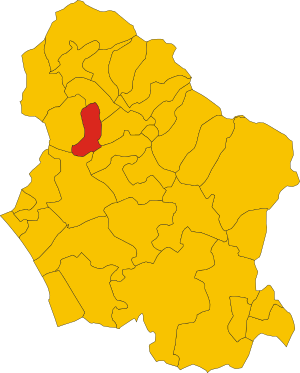
| Property / locator map image | |||||||||||||||
| Property / locator map image: Map of comune of Careggine (province of Lucca, region Tuscany, Italy).svg / rank | |||||||||||||||
Normal rank | |||||||||||||||
| Property / ISTAT ID | |||||||||||||||
046008 | |||||||||||||||
| Property / ISTAT ID: 046008 / rank | |||||||||||||||
Normal rank | |||||||||||||||
| Property / ISTAT ID: 046008 / reference | |||||||||||||||
| Property / coordinate location | |||||||||||||||
44°7'15"N, 10°19'35"E
| |||||||||||||||
| Property / coordinate location: 44°7'15"N, 10°19'35"E / rank | |||||||||||||||
Normal rank | |||||||||||||||
| Property / coordinate location: 44°7'15"N, 10°19'35"E / reference | |||||||||||||||
| Property / country | |||||||||||||||
| Property / country: Italy / rank | |||||||||||||||
Normal rank | |||||||||||||||
| Property / country: Italy / reference | |||||||||||||||
| Property / Italian cadastre code | |||||||||||||||
B760 | |||||||||||||||
| Property / Italian cadastre code: B760 / rank | |||||||||||||||
Normal rank | |||||||||||||||
| Property / Italian cadastre code: B760 / reference | |||||||||||||||
| Property / Freebase ID | |||||||||||||||
| Property / Freebase ID: /m/0f6jq1 / rank | |||||||||||||||
Normal rank | |||||||||||||||
| Property / Freebase ID: /m/0f6jq1 / reference | |||||||||||||||
| Property / Freebase ID: /m/0f6jq1 / reference | |||||||||||||||
publication date: 28 October 2013
| |||||||||||||||
| Property / GeoNames ID | |||||||||||||||
| Property / GeoNames ID: 6543594 / rank | |||||||||||||||
Normal rank | |||||||||||||||
| Property / GeoNames ID: 6543594 / reference | |||||||||||||||
| Property / category for people born here | |||||||||||||||
| Property / category for people born here: Q2608405 / rank | |||||||||||||||
Normal rank | |||||||||||||||
| Property / category for people born here: Q2608405 / reference | |||||||||||||||
| Property / GND ID | |||||||||||||||
| Property / GND ID: 7644168-4 / rank | |||||||||||||||
Normal rank | |||||||||||||||
| Property / GND ID: 7644168-4 / reference | |||||||||||||||
| Property / topic's main category | |||||||||||||||
| Property / topic's main category: Category:Careggine / rank | |||||||||||||||
Normal rank | |||||||||||||||
| Property / topic's main category: Category:Careggine / reference | |||||||||||||||
| Property / official website | |||||||||||||||
| Property / official website: http://www.careggine.org / rank | |||||||||||||||
Normal rank | |||||||||||||||
| Property / official website: http://www.careggine.org / reference | |||||||||||||||
| Property / VIAF ID | |||||||||||||||
| Property / VIAF ID: 245878511 / rank | |||||||||||||||
Normal rank | |||||||||||||||
| Property / VIAF ID: 245878511 / reference | |||||||||||||||
| Property / VIAF ID: 245878511 / reference | |||||||||||||||
retrieved: 3 August 2015
| |||||||||||||||
| Property / elevation above sea level | |||||||||||||||
882±1 metre
| |||||||||||||||
| Property / elevation above sea level: 882±1 metre / rank | |||||||||||||||
Normal rank | |||||||||||||||
| Property / elevation above sea level: 882±1 metre / reference | |||||||||||||||
| Property / licence plate code | |||||||||||||||
LU | |||||||||||||||
| Property / licence plate code: LU / rank | |||||||||||||||
Normal rank | |||||||||||||||
| Property / coordinates of northernmost point | |||||||||||||||
44°8'21.329"N, 10°19'59.891"E
| |||||||||||||||
| Property / coordinates of northernmost point: 44°8'21.329"N, 10°19'59.891"E / rank | |||||||||||||||
Normal rank | |||||||||||||||
| Property / coordinates of northernmost point: 44°8'21.329"N, 10°19'59.891"E / reference | |||||||||||||||
| Property / coordinates of southernmost point | |||||||||||||||
44°3'36.904"N, 10°18'7.657"E
| |||||||||||||||
| Property / coordinates of southernmost point: 44°3'36.904"N, 10°18'7.657"E / rank | |||||||||||||||
Normal rank | |||||||||||||||
| Property / coordinates of southernmost point: 44°3'36.904"N, 10°18'7.657"E / reference | |||||||||||||||
| Property / coordinates of easternmost point | |||||||||||||||
44°6'25.801"N, 10°20'46.842"E
| |||||||||||||||
| Property / coordinates of easternmost point: 44°6'25.801"N, 10°20'46.842"E / rank | |||||||||||||||
Normal rank | |||||||||||||||
| Property / coordinates of easternmost point: 44°6'25.801"N, 10°20'46.842"E / reference | |||||||||||||||
| Property / coordinates of westernmost point | |||||||||||||||
44°4'17.400"N, 10°17'10.586"E
| |||||||||||||||
| Property / coordinates of westernmost point: 44°4'17.400"N, 10°17'10.586"E / rank | |||||||||||||||
Normal rank | |||||||||||||||
| Property / coordinates of westernmost point: 44°4'17.400"N, 10°17'10.586"E / reference | |||||||||||||||
| Property / OSM relation ID | |||||||||||||||
| Property / OSM relation ID: 42835 / rank | |||||||||||||||
Normal rank | |||||||||||||||
| Property / capital | |||||||||||||||
| Property / capital: Careggine / rank | |||||||||||||||
Normal rank | |||||||||||||||
| Property / area | |||||||||||||||
24.08 square kilometre
| |||||||||||||||
| Property / area: 24.08 square kilometre / rank | |||||||||||||||
Normal rank | |||||||||||||||
| Property / area: 24.08 square kilometre / qualifier | |||||||||||||||
point in time: 9 October 2011
| |||||||||||||||
| Property / area: 24.08 square kilometre / reference | |||||||||||||||
| Property / area: 24.08 square kilometre / reference | |||||||||||||||
| Property / area: 24.08 square kilometre / reference | |||||||||||||||
title: Superficie di Comuni Province e Regioni italiane al 9 ottobre 2011 (Italian) | |||||||||||||||
| Property / area: 24.08 square kilometre / reference | |||||||||||||||
retrieved: 16 March 2019
| |||||||||||||||
| Property / area: 24.08 square kilometre / reference | |||||||||||||||
| Property / population | |||||||||||||||
549
| |||||||||||||||
| Property / population: 549 / rank | |||||||||||||||
Normal rank | |||||||||||||||
| Property / population: 549 / qualifier | |||||||||||||||
point in time: 1 January 2017
| |||||||||||||||
| Property / population: 549 / qualifier | |||||||||||||||
| Property / population: 549 / reference | |||||||||||||||
| Property / population | |||||||||||||||
539
| |||||||||||||||
| Property / population: 539 / rank | |||||||||||||||
Preferred rank | |||||||||||||||
| Property / population: 539 / qualifier | |||||||||||||||
point in time: 1 January 2018
| |||||||||||||||
| Property / population: 539 / qualifier | |||||||||||||||
| Property / population: 539 / reference | |||||||||||||||
| Property / population: 539 / reference | |||||||||||||||
title: Popolazione Residente al 1° Gennaio 2018 (Italian) | |||||||||||||||
| Property / population: 539 / reference | |||||||||||||||
retrieved: 16 March 2019
| |||||||||||||||
| Property / population: 539 / reference | |||||||||||||||
| Property / population | |||||||||||||||
539
| |||||||||||||||
| Property / population: 539 / rank | |||||||||||||||
Normal rank | |||||||||||||||
| Property / population: 539 / qualifier | |||||||||||||||
point in time: 1 January 2018
| |||||||||||||||
| Property / population: 539 / qualifier | |||||||||||||||
| Property / population: 539 / reference | |||||||||||||||
| Property / population: 539 / reference | |||||||||||||||
title: Popolazione Residente al 1° Gennaio 2018 (Italian) | |||||||||||||||
| Property / population: 539 / reference | |||||||||||||||
retrieved: 16 March 2019
| |||||||||||||||
| Property / population: 539 / reference | |||||||||||||||
| Property / population | |||||||||||||||
511
| |||||||||||||||
| Property / population: 511 / rank | |||||||||||||||
Preferred rank | |||||||||||||||
| Property / population: 511 / qualifier | |||||||||||||||
point in time: 1 January 2023
| |||||||||||||||
| Property / population: 511 / reference | |||||||||||||||
| Property / IndicePA ID | |||||||||||||||
| Property / IndicePA ID: c_b760 / rank | |||||||||||||||
Normal rank | |||||||||||||||
| Property / Who's on First ID | |||||||||||||||
| Property / Who's on First ID: 101797673 / rank | |||||||||||||||
Normal rank | |||||||||||||||
| Property / Wiki Loves Monuments ID | |||||||||||||||
09B7600000 | |||||||||||||||
| Property / Wiki Loves Monuments ID: 09B7600000 / rank | |||||||||||||||
Normal rank | |||||||||||||||
| Property / Wiki Loves Monuments ID: 09B7600000 / qualifier | |||||||||||||||
start time: 1 September 2020
| |||||||||||||||
| Property / Wiki Loves Monuments ID: 09B7600000 / reference | |||||||||||||||
| Property / P98796 | |||||||||||||||
| Property / P98796: Category:Views of Careggine / rank | |||||||||||||||
Normal rank | |||||||||||||||
| Property / De Agostini ID | |||||||||||||||
| Property / De Agostini ID: Caréggine / rank | |||||||||||||||
Normal rank | |||||||||||||||
| Property / De Agostini ID: Caréggine / qualifier | |||||||||||||||
named as: Caréggine | |||||||||||||||
| Property / patron saint | |||||||||||||||
| Property / patron saint: Saint Peter / rank | |||||||||||||||
Normal rank | |||||||||||||||
| Property / patron saint: Saint Peter / reference | |||||||||||||||
| Property / patron saint: Saint Peter / reference | |||||||||||||||
| Property / seismic classification | |||||||||||||||
| Property / seismic classification: 2 / rank | |||||||||||||||
Normal rank | |||||||||||||||
| Property / seismic classification: 2 / reference | |||||||||||||||
| Property / seismic classification: 2 / reference | |||||||||||||||
| Property / seismic classification: 2 / reference | |||||||||||||||
retrieved: 27 August 2022
| |||||||||||||||
| Property / EU Knowledge Graph item ID | |||||||||||||||
Q290895 | |||||||||||||||
| Property / EU Knowledge Graph item ID: Q290895 / rank | |||||||||||||||
Normal rank | |||||||||||||||
| Property / demonym | |||||||||||||||
caregginini (Italian) | |||||||||||||||
| Property / demonym: caregginini (Italian) / rank | |||||||||||||||
Normal rank | |||||||||||||||
| Property / demonym: caregginini (Italian) / qualifier | |||||||||||||||
| Property / demonym: caregginini (Italian) / reference | |||||||||||||||
| Property / office held by head of government | |||||||||||||||
| Property / office held by head of government: mayor of Careggine / rank | |||||||||||||||
Normal rank | |||||||||||||||
| Property / image | |||||||||||||||
| Property / image: CaregginePanorama2.jpg / rank | |||||||||||||||
Preferred rank | |||||||||||||||
| links / bgwiki / name | links / bgwiki / name | ||||||||||||||
| links / dewiki / name | links / dewiki / name | ||||||||||||||
| links / enwiki / name | links / enwiki / name | ||||||||||||||
| links / eswiki / name | links / eswiki / name | ||||||||||||||
| links / frwiki / name | links / frwiki / name | ||||||||||||||
| links / huwiki / name | links / huwiki / name | ||||||||||||||
| links / itwiki / name | links / itwiki / name | ||||||||||||||
| links / nlwiki / name | links / nlwiki / name | ||||||||||||||
| links / plwiki / name | links / plwiki / name | ||||||||||||||
| links / ptwiki / name | links / ptwiki / name | ||||||||||||||
| links / rowiki / name | links / rowiki / name | ||||||||||||||
| links / svwiki / name | links / svwiki / name | ||||||||||||||
Latest revision as of 18:39, 28 May 2024
Italian comune
| Language | Label | Description | Also known as |
|---|---|---|---|
| English | Careggine |
Italian comune |
Statements

55030
0 references
Careggine
0 references
0583
0 references
.svg)
Map of comune of Careggine (province of Lucca, region Tuscany, Italy).svg
4,176 × 5,190; 77 KB
4,176 × 5,190; 77 KB
0 references
LU
0 references


24.08 square kilometre
9 October 2011
5 references
Superficie di Comuni Province e Regioni italiane al 9 ottobre 2011 (Italian)
16 March 2019
549
1 January 2017
1 reference
539
1 January 2018
4 references
Popolazione Residente al 1° Gennaio 2018 (Italian)
16 March 2019
539
1 January 2018
4 references
Popolazione Residente al 1° Gennaio 2018 (Italian)
16 March 2019
caregginini (Italian)
1 reference

.svg)
Identifiers
398730465
0 references
Q290895
0 references