Stigliano (Q295949): Difference between revisions
Jump to navigation
Jump to search
(Removed claim: country (P32): Italy (Q15), Removing this statements since they changed in Wikidata) |
(Changed an Item: Adding these statements since they where added in Wikidata) |
||||||||||||||
| (15 intermediate revisions by 2 users not shown) | |||||||||||||||
| label / it | label / it | ||||||||||||||
STIGLIANO | |||||||||||||||
| label / ga | label / ga | ||||||||||||||
Stigliano | |||||||||||||||
| description / tr | description / tr | ||||||||||||||
İtalya | Matera iline bağlı komün (Basilicata, İtalya) | ||||||||||||||
| description / hu | description / hu | ||||||||||||||
község Olaszországban | |||||||||||||||
| Property / instance of | |||||||||||||||
| Property / instance of: beneficiary / rank | |||||||||||||||
| Property / instance of | |||||||||||||||
| Property / instance of: commune of Italy / rank | |||||||||||||||
Normal rank | |||||||||||||||
| Property / instance of | |||||||||||||||
| Property / instance of: beneficiary / rank | |||||||||||||||
Preferred rank | |||||||||||||||
| Property / instance of | |||||||||||||||
| Property / instance of: public beneficiary / rank | |||||||||||||||
Normal rank | |||||||||||||||
| Property / instance of: public beneficiary / qualifier | |||||||||||||||
| Property / Dewey Decimal Classification | |||||||||||||||
2--45772 | |||||||||||||||
| Property / Dewey Decimal Classification: 2--45772 / rank | |||||||||||||||
Deprecated rank | |||||||||||||||
| Property / Commons category | |||||||||||||||
Stigliano | |||||||||||||||
| Property / Commons category: Stigliano / rank | |||||||||||||||
Normal rank | |||||||||||||||
| Property / located in the administrative territorial entity | |||||||||||||||
| Property / located in the administrative territorial entity: Province of Matera / rank | |||||||||||||||
Normal rank | |||||||||||||||
| Property / located in the administrative territorial entity: Province of Matera / reference | |||||||||||||||
| Property / postal code | |||||||||||||||
75018 | |||||||||||||||
| Property / postal code: 75018 / rank | |||||||||||||||
Normal rank | |||||||||||||||
| Property / shares border with | |||||||||||||||
| Property / shares border with: Accettura / rank | |||||||||||||||
Normal rank | |||||||||||||||
| Property / shares border with | |||||||||||||||
| Property / shares border with: Aliano / rank | |||||||||||||||
Normal rank | |||||||||||||||
| Property / shares border with: Aliano / reference | |||||||||||||||
| Property / shares border with | |||||||||||||||
| Property / shares border with: Craco / rank | |||||||||||||||
Normal rank | |||||||||||||||
| Property / shares border with: Craco / reference | |||||||||||||||
| Property / shares border with | |||||||||||||||
| Property / shares border with: Gorgoglione / rank | |||||||||||||||
Normal rank | |||||||||||||||
| Property / shares border with | |||||||||||||||
| Property / shares border with: Montalbano Jonico / rank | |||||||||||||||
Normal rank | |||||||||||||||
| Property / shares border with: Montalbano Jonico / reference | |||||||||||||||
| Property / shares border with | |||||||||||||||
| Property / shares border with: San Mauro Forte / rank | |||||||||||||||
Normal rank | |||||||||||||||
| Property / shares border with | |||||||||||||||
| Property / shares border with: Sant'Arcangelo / rank | |||||||||||||||
Normal rank | |||||||||||||||
| Property / shares border with: Sant'Arcangelo / reference | |||||||||||||||
| Property / shares border with | |||||||||||||||
| Property / shares border with: Cirigliano / rank | |||||||||||||||
Normal rank | |||||||||||||||
| Property / shares border with: Cirigliano / reference | |||||||||||||||
| Property / shares border with | |||||||||||||||
| Property / shares border with: Tursi / rank | |||||||||||||||
Normal rank | |||||||||||||||
| Property / shares border with: Tursi / reference | |||||||||||||||
| Property / located in time zone | |||||||||||||||
| Property / located in time zone: UTC+01:00 / rank | |||||||||||||||
Normal rank | |||||||||||||||
| Property / located in time zone: UTC+01:00 / qualifier | |||||||||||||||
| Property / located in time zone: UTC+01:00 / reference | |||||||||||||||
| Property / located in time zone | |||||||||||||||
| Property / located in time zone: UTC+02:00 / rank | |||||||||||||||
Normal rank | |||||||||||||||
| Property / located in time zone: UTC+02:00 / qualifier | |||||||||||||||
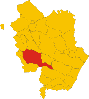
| Property / locator map image | |||||||||||||||
| Property / locator map image: Map of comune of Stigliano (province of Matera, region Basilicata, Italy).svg / rank | |||||||||||||||
Normal rank | |||||||||||||||
| Property / locator map image: Map of comune of Stigliano (province of Matera, region Basilicata, Italy).svg / reference | |||||||||||||||
| Property / ISTAT ID | |||||||||||||||
077027 | |||||||||||||||
| Property / ISTAT ID: 077027 / rank | |||||||||||||||
Normal rank | |||||||||||||||
| Property / ISTAT ID: 077027 / reference | |||||||||||||||
| Property / coordinate location | |||||||||||||||
40°24'0"N, 16°14'0"E
| |||||||||||||||
| Property / coordinate location: 40°24'0"N, 16°14'0"E / rank | |||||||||||||||
Normal rank | |||||||||||||||
| Property / coordinate location: 40°24'0"N, 16°14'0"E / reference | |||||||||||||||
| Property / country | |||||||||||||||
| Property / country: Italy / rank | |||||||||||||||
Normal rank | |||||||||||||||
| Property / country: Italy / reference | |||||||||||||||
| Property / local dialing code | |||||||||||||||
0835 | |||||||||||||||
| Property / local dialing code: 0835 / rank | |||||||||||||||
Normal rank | |||||||||||||||
| Property / local dialing code: 0835 / reference | |||||||||||||||
| Property / Italian cadastre code | |||||||||||||||
I954 | |||||||||||||||
| Property / Italian cadastre code: I954 / rank | |||||||||||||||
Normal rank | |||||||||||||||
| Property / Italian cadastre code: I954 / reference | |||||||||||||||
| Property / Freebase ID | |||||||||||||||
| Property / Freebase ID: /m/0fgvfz / rank | |||||||||||||||
Normal rank | |||||||||||||||
| Property / Freebase ID: /m/0fgvfz / reference | |||||||||||||||
| Property / Freebase ID: /m/0fgvfz / reference | |||||||||||||||
publication date: 28 October 2013
| |||||||||||||||
| Property / twinned administrative body | |||||||||||||||
| Property / twinned administrative body: Gigean / rank | |||||||||||||||
Normal rank | |||||||||||||||
| Property / twinned administrative body: Gigean / reference | |||||||||||||||
| Property / twinned administrative body | |||||||||||||||
| Property / twinned administrative body: Cardano al Campo / rank | |||||||||||||||
Normal rank | |||||||||||||||
| Property / twinned administrative body: Cardano al Campo / reference | |||||||||||||||
| Property / GeoNames ID | |||||||||||||||
| Property / GeoNames ID: 6539843 / rank | |||||||||||||||
Normal rank | |||||||||||||||
| Property / GeoNames ID: 6539843 / reference | |||||||||||||||
| Property / category for people born here | |||||||||||||||
| Property / category for people born here: Q2599842 / rank | |||||||||||||||
Normal rank | |||||||||||||||
| Property / category for people born here: Q2599842 / reference | |||||||||||||||
| Property / image | |||||||||||||||
| Property / image: Stigliano Panorama.jpg / rank | |||||||||||||||
Normal rank | |||||||||||||||
| Property / VIAF ID | |||||||||||||||
| Property / VIAF ID: 247414229 / rank | |||||||||||||||
Normal rank | |||||||||||||||
| Property / VIAF ID: 247414229 / reference | |||||||||||||||
| Property / VIAF ID: 247414229 / reference | |||||||||||||||
retrieved: 2 August 2015
| |||||||||||||||
| Property / elevation above sea level | |||||||||||||||
909±1 metre
| |||||||||||||||
| Property / elevation above sea level: 909±1 metre / rank | |||||||||||||||
Normal rank | |||||||||||||||
| Property / elevation above sea level: 909±1 metre / reference | |||||||||||||||
| Property / official website | |||||||||||||||
| Property / official website: http://www.stigliano.net / rank | |||||||||||||||
Normal rank | |||||||||||||||
| Property / official website: http://www.stigliano.net / reference | |||||||||||||||
| Property / topic's main category | |||||||||||||||
| Property / topic's main category: Category:Stigliano (comune, Italy) / rank | |||||||||||||||
Normal rank | |||||||||||||||
| Property / licence plate code | |||||||||||||||
MT | |||||||||||||||
| Property / licence plate code: MT / rank | |||||||||||||||
Normal rank | |||||||||||||||
| Property / coordinates of northernmost point | |||||||||||||||
40°27'5.332"N, 16°13'5.228"E
| |||||||||||||||
| Property / coordinates of northernmost point: 40°27'5.332"N, 16°13'5.228"E / rank | |||||||||||||||
Normal rank | |||||||||||||||
| Property / coordinates of northernmost point: 40°27'5.332"N, 16°13'5.228"E / reference | |||||||||||||||
| Property / coordinates of southernmost point | |||||||||||||||
40°17'23.932"N, 16°29'51.353"E
| |||||||||||||||
| Property / coordinates of southernmost point: 40°17'23.932"N, 16°29'51.353"E / rank | |||||||||||||||
Normal rank | |||||||||||||||
| Property / coordinates of southernmost point: 40°17'23.932"N, 16°29'51.353"E / reference | |||||||||||||||
| Property / coordinates of easternmost point | |||||||||||||||
40°17'23.932"N, 16°29'51.353"E
| |||||||||||||||
| Property / coordinates of easternmost point: 40°17'23.932"N, 16°29'51.353"E / rank | |||||||||||||||
Normal rank | |||||||||||||||
| Property / coordinates of easternmost point: 40°17'23.932"N, 16°29'51.353"E / reference | |||||||||||||||
| Property / coordinates of westernmost point | |||||||||||||||
40°25'57.324"N, 16°10'34.428"E
| |||||||||||||||
| Property / coordinates of westernmost point: 40°25'57.324"N, 16°10'34.428"E / rank | |||||||||||||||
Normal rank | |||||||||||||||
| Property / coordinates of westernmost point: 40°25'57.324"N, 16°10'34.428"E / reference | |||||||||||||||
| Property / OSM relation ID | |||||||||||||||
| Property / OSM relation ID: 40431 / rank | |||||||||||||||
Normal rank | |||||||||||||||
| Property / capital | |||||||||||||||
| Property / capital: Stigliano / rank | |||||||||||||||
Normal rank | |||||||||||||||
| Property / area | |||||||||||||||
211.15 square kilometre
| |||||||||||||||
| Property / area: 211.15 square kilometre / rank | |||||||||||||||
Normal rank | |||||||||||||||
| Property / area: 211.15 square kilometre / qualifier | |||||||||||||||
point in time: 9 October 2011
| |||||||||||||||
| Property / area: 211.15 square kilometre / reference | |||||||||||||||
| Property / area: 211.15 square kilometre / reference | |||||||||||||||
| Property / area: 211.15 square kilometre / reference | |||||||||||||||
title: Superficie di Comuni Province e Regioni italiane al 9 ottobre 2011 (Italian) | |||||||||||||||
| Property / area: 211.15 square kilometre / reference | |||||||||||||||
retrieved: 16 March 2019
| |||||||||||||||
| Property / area: 211.15 square kilometre / reference | |||||||||||||||
| Property / population | |||||||||||||||
4,223
| |||||||||||||||
| Property / population: 4,223 / rank | |||||||||||||||
Normal rank | |||||||||||||||
| Property / population: 4,223 / qualifier | |||||||||||||||
point in time: 1 January 2017
| |||||||||||||||
| Property / population: 4,223 / qualifier | |||||||||||||||
| Property / population: 4,223 / reference | |||||||||||||||
| Property / population | |||||||||||||||
4,112
| |||||||||||||||
| Property / population: 4,112 / rank | |||||||||||||||
Preferred rank | |||||||||||||||
| Property / population: 4,112 / qualifier | |||||||||||||||
point in time: 1 January 2018
| |||||||||||||||
| Property / population: 4,112 / qualifier | |||||||||||||||
| Property / population: 4,112 / reference | |||||||||||||||
| Property / population: 4,112 / reference | |||||||||||||||
title: Popolazione Residente al 1° Gennaio 2018 (Italian) | |||||||||||||||
| Property / population: 4,112 / reference | |||||||||||||||
retrieved: 16 March 2019
| |||||||||||||||
| Property / population: 4,112 / reference | |||||||||||||||
| Property / population | |||||||||||||||
4,112
| |||||||||||||||
| Property / population: 4,112 / rank | |||||||||||||||
Normal rank | |||||||||||||||
| Property / population: 4,112 / qualifier | |||||||||||||||
point in time: 1 January 2018
| |||||||||||||||
| Property / population: 4,112 / qualifier | |||||||||||||||
| Property / population: 4,112 / reference | |||||||||||||||
| Property / population: 4,112 / reference | |||||||||||||||
title: Popolazione Residente al 1° Gennaio 2018 (Italian) | |||||||||||||||
| Property / population: 4,112 / reference | |||||||||||||||
retrieved: 16 March 2019
| |||||||||||||||
| Property / population: 4,112 / reference | |||||||||||||||
| Property / population | |||||||||||||||
3,584
| |||||||||||||||
| Property / population: 3,584 / rank | |||||||||||||||
Preferred rank | |||||||||||||||
| Property / population: 3,584 / qualifier | |||||||||||||||
point in time: 1 January 2023
| |||||||||||||||
| Property / population: 3,584 / reference | |||||||||||||||
| Property / IndicePA ID | |||||||||||||||
| Property / IndicePA ID: c_i954 / rank | |||||||||||||||
Normal rank | |||||||||||||||
| Property / Who's on First ID | |||||||||||||||
| Property / Who's on First ID: 101802031 / rank | |||||||||||||||
Normal rank | |||||||||||||||
| Property / Wiki Loves Monuments ID | |||||||||||||||
17I9540000 | |||||||||||||||
| Property / Wiki Loves Monuments ID: 17I9540000 / rank | |||||||||||||||
Normal rank | |||||||||||||||
| Property / Wiki Loves Monuments ID: 17I9540000 / qualifier | |||||||||||||||
start time: 1 September 2020
| |||||||||||||||
| Property / Wiki Loves Monuments ID: 17I9540000 / reference | |||||||||||||||
| Property / patron saint | |||||||||||||||
| Property / patron saint: Anthony of Padua / rank | |||||||||||||||
Normal rank | |||||||||||||||
| Property / patron saint: Anthony of Padua / reference | |||||||||||||||
| Property / patron saint: Anthony of Padua / reference | |||||||||||||||
| Property / seismic classification | |||||||||||||||
| Property / seismic classification: 2 / rank | |||||||||||||||
Normal rank | |||||||||||||||
| Property / seismic classification: 2 / reference | |||||||||||||||
| Property / seismic classification: 2 / reference | |||||||||||||||
| Property / seismic classification: 2 / reference | |||||||||||||||
retrieved: 27 August 2022
| |||||||||||||||
| Property / EU Knowledge Graph item ID | |||||||||||||||
Q295949 | |||||||||||||||
| Property / EU Knowledge Graph item ID: Q295949 / rank | |||||||||||||||
Normal rank | |||||||||||||||
Latest revision as of 06:57, 11 December 2023
Italian comune
| Language | Label | Description | Also known as |
|---|---|---|---|
| English | Stigliano |
Italian comune |
Statements

75018
0 references
Stigliano
0 references
.svg)
Map of comune of Stigliano (province of Matera, region Basilicata, Italy).svg
2,355 × 2,616; 92 KB
2,355 × 2,616; 92 KB
1 reference

MT
0 references


.svg)
211.15 square kilometre
9 October 2011
5 references
Superficie di Comuni Province e Regioni italiane al 9 ottobre 2011 (Italian)
16 March 2019
4,223
1 January 2017
1 reference
4,112
1 January 2018
4 references
Popolazione Residente al 1° Gennaio 2018 (Italian)
16 March 2019
4,112
1 January 2018
4 references
Popolazione Residente al 1° Gennaio 2018 (Italian)
16 March 2019
Identifiers
108030776
0 references
2--45772
0 references
Q295949
0 references