Oniferi (Q289052): Difference between revisions
Jump to navigation
Jump to search
(Changed an Item: Sitelinks in wikidata changed) |
(Changed label, description and/or aliases in de, it: The description in Wikidata changed) |
||||||||||||||
| (15 intermediate revisions by 2 users not shown) | |||||||||||||||
| label / ga | label / ga | ||||||||||||||
Oniferi | |||||||||||||||
| label / lt | label / lt | ||||||||||||||
Oniferi | |||||||||||||||
| aliases / de / 0 | aliases / de / 0 | ||||||||||||||
Oniéri | |||||||||||||||
| aliases / en / 0 | aliases / en / 0 | ||||||||||||||
Oniéri | |||||||||||||||
| aliases / es / 0 | aliases / es / 0 | ||||||||||||||
Oniéri | |||||||||||||||
| aliases / fr / 0 | aliases / fr / 0 | ||||||||||||||
Oniéri | |||||||||||||||
| aliases / it / 0 | aliases / it / 0 | ||||||||||||||
Oniéri | |||||||||||||||
| aliases / lt / 0 | aliases / lt / 0 | ||||||||||||||
Oniéri | |||||||||||||||
| aliases / nl / 0 | aliases / nl / 0 | ||||||||||||||
Oniéri | |||||||||||||||
| aliases / pt / 0 | aliases / pt / 0 | ||||||||||||||
Oniéri | |||||||||||||||
| aliases / sv / 0 | aliases / sv / 0 | ||||||||||||||
Oniéri | |||||||||||||||
| description / de | description / de | ||||||||||||||
italienische Gemeinde | italienische Gemeinde auf Sardinien | ||||||||||||||
| description / it | description / it | ||||||||||||||
comune italiano | comune italiano in Sardegna | ||||||||||||||
| Property / country | |||||||||||||||
| Property / country: Italy / rank | |||||||||||||||
| Property / instance of | |||||||||||||||
| Property / instance of: beneficiary / rank | |||||||||||||||
| Property / instance of | |||||||||||||||
| Property / instance of: commune of Italy / rank | |||||||||||||||
Normal rank | |||||||||||||||
| Property / Commons category | |||||||||||||||
Oniferi | |||||||||||||||
| Property / Commons category: Oniferi / rank | |||||||||||||||
Normal rank | |||||||||||||||
| Property / located in the administrative territorial entity | |||||||||||||||
| Property / located in the administrative territorial entity: Province of Nuoro / rank | |||||||||||||||
Normal rank | |||||||||||||||
| Property / located in the administrative territorial entity: Province of Nuoro / qualifier | |||||||||||||||
start time: 2 January 1927Gregorian
| |||||||||||||||
| Property / located in the administrative territorial entity: Province of Nuoro / reference | |||||||||||||||
| Property / postal code | |||||||||||||||
08020 | |||||||||||||||
| Property / postal code: 08020 / rank | |||||||||||||||
Normal rank | |||||||||||||||
| Property / postal code: 08020 / reference | |||||||||||||||
| Property / shares border with | |||||||||||||||
| Property / shares border with: Bono / rank | |||||||||||||||
Normal rank | |||||||||||||||
| Property / shares border with: Bono / reference | |||||||||||||||
| Property / shares border with | |||||||||||||||
| Property / shares border with: Orotelli / rank | |||||||||||||||
Normal rank | |||||||||||||||
| Property / shares border with: Orotelli / reference | |||||||||||||||
| Property / shares border with | |||||||||||||||
| Property / shares border with: Benetutti / rank | |||||||||||||||
Normal rank | |||||||||||||||
| Property / shares border with: Benetutti / reference | |||||||||||||||
| Property / shares border with | |||||||||||||||
| Property / shares border with: Orani / rank | |||||||||||||||
Normal rank | |||||||||||||||
| Property / local dialing code | |||||||||||||||
0784 | |||||||||||||||
| Property / local dialing code: 0784 / rank | |||||||||||||||
Normal rank | |||||||||||||||
| Property / local dialing code: 0784 / reference | |||||||||||||||
| Property / located in time zone | |||||||||||||||
| Property / located in time zone: UTC+01:00 / rank | |||||||||||||||
Normal rank | |||||||||||||||
| Property / located in time zone: UTC+01:00 / qualifier | |||||||||||||||
| Property / located in time zone | |||||||||||||||
| Property / located in time zone: UTC+02:00 / rank | |||||||||||||||
Normal rank | |||||||||||||||
| Property / located in time zone: UTC+02:00 / qualifier | |||||||||||||||
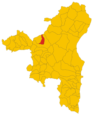
| Property / locator map image | |||||||||||||||
| Property / locator map image: Map of comune of Oniferi (province of Nuoro, region Sardinia, Italy) - 2016.svg / rank | |||||||||||||||
Normal rank | |||||||||||||||
| Property / locator map image: Map of comune of Oniferi (province of Nuoro, region Sardinia, Italy) - 2016.svg / reference | |||||||||||||||
| Property / ISTAT ID | |||||||||||||||
091060 | |||||||||||||||
| Property / ISTAT ID: 091060 / rank | |||||||||||||||
Normal rank | |||||||||||||||
| Property / ISTAT ID: 091060 / reference | |||||||||||||||
| Property / country | |||||||||||||||
| Property / country: Italy / rank | |||||||||||||||
Normal rank | |||||||||||||||
| Property / country: Italy / reference | |||||||||||||||
| Property / Italian cadastre code | |||||||||||||||
G071 | |||||||||||||||
| Property / Italian cadastre code: G071 / rank | |||||||||||||||
Normal rank | |||||||||||||||
| Property / Italian cadastre code: G071 / reference | |||||||||||||||
| Property / Freebase ID | |||||||||||||||
| Property / Freebase ID: /m/0gqw5p / rank | |||||||||||||||
Normal rank | |||||||||||||||
| Property / Freebase ID: /m/0gqw5p / reference | |||||||||||||||
| Property / Freebase ID: /m/0gqw5p / reference | |||||||||||||||
publication date: 28 October 2013
| |||||||||||||||
| Property / GeoNames ID | |||||||||||||||
| Property / GeoNames ID: 6539264 / rank | |||||||||||||||
Normal rank | |||||||||||||||
| Property / GeoNames ID: 6539264 / reference | |||||||||||||||
| Property / topic's main category | |||||||||||||||
| Property / topic's main category: Category:Oniferi / rank | |||||||||||||||
Normal rank | |||||||||||||||
| Property / topic's main category: Category:Oniferi / reference | |||||||||||||||
| Property / official website | |||||||||||||||
| Property / official website: http://www.comune.oniferi.nu.it / rank | |||||||||||||||
Normal rank | |||||||||||||||
| Property / official website: http://www.comune.oniferi.nu.it / reference | |||||||||||||||
| Property / elevation above sea level | |||||||||||||||
478±1 metre
| |||||||||||||||
| Property / elevation above sea level: 478±1 metre / rank | |||||||||||||||
Normal rank | |||||||||||||||
| Property / elevation above sea level: 478±1 metre / reference | |||||||||||||||
| Property / coordinate location | |||||||||||||||
40°16'18"N, 9°10'13"E
| |||||||||||||||
| Property / coordinate location: 40°16'18"N, 9°10'13"E / rank | |||||||||||||||
Normal rank | |||||||||||||||
| Property / coordinate location: 40°16'18"N, 9°10'13"E / reference | |||||||||||||||
| Property / image | |||||||||||||||
| Property / image: Oniferi - Costume tradizionale (01).JPG / rank | |||||||||||||||
Normal rank | |||||||||||||||
| Property / coordinates of northernmost point | |||||||||||||||
40°22'6.514"N, 9°9'41.040"E
| |||||||||||||||
| Property / coordinates of northernmost point: 40°22'6.514"N, 9°9'41.040"E / rank | |||||||||||||||
Normal rank | |||||||||||||||
| Property / coordinates of northernmost point: 40°22'6.514"N, 9°9'41.040"E / reference | |||||||||||||||
| Property / coordinates of southernmost point | |||||||||||||||
40°15'47.815"N, 9°10'9.563"E
| |||||||||||||||
| Property / coordinates of southernmost point: 40°15'47.815"N, 9°10'9.563"E / rank | |||||||||||||||
Normal rank | |||||||||||||||
| Property / coordinates of southernmost point: 40°15'47.815"N, 9°10'9.563"E / reference | |||||||||||||||
| Property / coordinates of easternmost point | |||||||||||||||
40°18'42.635"N, 9°11'29.440"E
| |||||||||||||||
| Property / coordinates of easternmost point: 40°18'42.635"N, 9°11'29.440"E / rank | |||||||||||||||
Normal rank | |||||||||||||||
| Property / coordinates of easternmost point: 40°18'42.635"N, 9°11'29.440"E / reference | |||||||||||||||
| Property / coordinates of westernmost point | |||||||||||||||
40°16'15.118"N, 9°6'42.242"E
| |||||||||||||||
| Property / coordinates of westernmost point: 40°16'15.118"N, 9°6'42.242"E / rank | |||||||||||||||
Normal rank | |||||||||||||||
| Property / coordinates of westernmost point: 40°16'15.118"N, 9°6'42.242"E / reference | |||||||||||||||
| Property / OSM relation ID | |||||||||||||||
| Property / OSM relation ID: 40468 / rank | |||||||||||||||
Normal rank | |||||||||||||||
| Property / capital | |||||||||||||||
| Property / capital: Oniferi / rank | |||||||||||||||
Normal rank | |||||||||||||||
| Property / area | |||||||||||||||
35.67 square kilometre
| |||||||||||||||
| Property / area: 35.67 square kilometre / rank | |||||||||||||||
Normal rank | |||||||||||||||
| Property / area: 35.67 square kilometre / qualifier | |||||||||||||||
point in time: 9 October 2011
| |||||||||||||||
| Property / area: 35.67 square kilometre / reference | |||||||||||||||
| Property / area: 35.67 square kilometre / reference | |||||||||||||||
| Property / area: 35.67 square kilometre / reference | |||||||||||||||
title: Superficie di Comuni Province e Regioni italiane al 9 ottobre 2011 (Italian) | |||||||||||||||
| Property / area: 35.67 square kilometre / reference | |||||||||||||||
retrieved: 16 March 2019
| |||||||||||||||
| Property / area: 35.67 square kilometre / reference | |||||||||||||||
| Property / population | |||||||||||||||
898
| |||||||||||||||
| Property / population: 898 / rank | |||||||||||||||
Normal rank | |||||||||||||||
| Property / population: 898 / qualifier | |||||||||||||||
point in time: 1 January 2017
| |||||||||||||||
| Property / population: 898 / qualifier | |||||||||||||||
point in time: 1 January 2018
| |||||||||||||||
| Property / population: 898 / qualifier | |||||||||||||||
| Property / population: 898 / reference | |||||||||||||||
| Property / population: 898 / reference | |||||||||||||||
| Property / population: 898 / reference | |||||||||||||||
title: Popolazione Residente al 1° Gennaio 2018 (Italian) | |||||||||||||||
| Property / population: 898 / reference | |||||||||||||||
retrieved: 16 March 2019
| |||||||||||||||
| Property / population: 898 / reference | |||||||||||||||
| Property / licence plate code | |||||||||||||||
NU | |||||||||||||||
| Property / licence plate code: NU / rank | |||||||||||||||
Normal rank | |||||||||||||||
| Property / IndicePA ID | |||||||||||||||
| Property / IndicePA ID: c_g071 / rank | |||||||||||||||
Normal rank | |||||||||||||||
| Property / Who's on First ID | |||||||||||||||
| Property / Who's on First ID: 101777313 / rank | |||||||||||||||
Normal rank | |||||||||||||||
| Property / page banner | |||||||||||||||
| Property / page banner: Wv Oniferi banner.jpg / rank | |||||||||||||||
Normal rank | |||||||||||||||
| Property / Wiki Loves Monuments ID | |||||||||||||||
20G0710000 | |||||||||||||||
| Property / Wiki Loves Monuments ID: 20G0710000 / rank | |||||||||||||||
Normal rank | |||||||||||||||
| Property / Wiki Loves Monuments ID: 20G0710000 / qualifier | |||||||||||||||
start time: 1 September 2020
| |||||||||||||||
| Property / Wiki Loves Monuments ID: 20G0710000 / reference | |||||||||||||||
| Property / patron saint | |||||||||||||||
| Property / patron saint: Gavinus / rank | |||||||||||||||
Normal rank | |||||||||||||||
| Property / patron saint: Gavinus / reference | |||||||||||||||
| Property / patron saint: Gavinus / reference | |||||||||||||||
| Property / seismic classification | |||||||||||||||
| Property / seismic classification: 4 / rank | |||||||||||||||
Normal rank | |||||||||||||||
| Property / seismic classification: 4 / reference | |||||||||||||||
| Property / seismic classification: 4 / reference | |||||||||||||||
| Property / seismic classification: 4 / reference | |||||||||||||||
retrieved: 27 August 2022
| |||||||||||||||
| Property / EU Knowledge Graph item ID | |||||||||||||||
Q289052 | |||||||||||||||
| Property / EU Knowledge Graph item ID: Q289052 / rank | |||||||||||||||
Normal rank | |||||||||||||||
Latest revision as of 11:37, 9 June 2023
Italian comune
- Oniéri
| Language | Label | Description | Also known as |
|---|---|---|---|
| English | Oniferi |
Italian comune |
|
Statements

Oniferi
0 references
2 January 1927Gregorian
1 reference
_-_2016.svg)
Map of comune of Oniferi (province of Nuoro, region Sardinia, Italy) - 2016.svg
6,700 × 8,300; 168 KB
6,700 × 8,300; 168 KB
1 reference
.JPG)


_-_2016.svg)
.JPG)
35.67 square kilometre
9 October 2011
5 references
Superficie di Comuni Province e Regioni italiane al 9 ottobre 2011 (Italian)
16 March 2019
898
1 January 2017
1 January 2018
5 references
Popolazione Residente al 1° Gennaio 2018 (Italian)
16 March 2019
NU
0 references
Identifiers
844880914
0 references
Q289052
0 references