Atella, Basilicata (Q296197): Difference between revisions
Jump to navigation
Jump to search
(Removed claim: country (P32): Italy (Q15), Removing this statements since they changed in Wikidata) |
(Changed an Item: Adding these statements since they where added in Wikidata) |
||||||||||||||
| (17 intermediate revisions by 2 users not shown) | |||||||||||||||
| label / tr | label / tr | ||||||||||||||
Atella, Basilicata | |||||||||||||||
| label / ga | label / ga | ||||||||||||||
Atella, Basilicata | |||||||||||||||
| description / hu | description / hu | ||||||||||||||
község Olaszországban | |||||||||||||||
| Property / instance of | |||||||||||||||
| Property / instance of: beneficiary / rank | |||||||||||||||
| Property / instance of | |||||||||||||||
| Property / instance of: commune of Italy / rank | |||||||||||||||
Normal rank | |||||||||||||||
| Property / instance of | |||||||||||||||
| Property / instance of: beneficiary / rank | |||||||||||||||
Preferred rank | |||||||||||||||
| Property / instance of | |||||||||||||||
| Property / instance of: public beneficiary / rank | |||||||||||||||
Normal rank | |||||||||||||||
| Property / instance of: public beneficiary / qualifier | |||||||||||||||
| Property / Commons category | |||||||||||||||
Atella | |||||||||||||||
| Property / Commons category: Atella / rank | |||||||||||||||
Normal rank | |||||||||||||||
| Property / Commons category: Atella / reference | |||||||||||||||
| Property / located in the administrative territorial entity | |||||||||||||||
| Property / located in the administrative territorial entity: Province of Potenza / rank | |||||||||||||||
Normal rank | |||||||||||||||
| Property / located in the administrative territorial entity: Province of Potenza / reference | |||||||||||||||
| Property / postal code | |||||||||||||||
85020 | |||||||||||||||
| Property / postal code: 85020 / rank | |||||||||||||||
Normal rank | |||||||||||||||
| Property / postal code: 85020 / reference | |||||||||||||||
| Property / shares border with | |||||||||||||||
| Property / shares border with: Avigliano / rank | |||||||||||||||
Normal rank | |||||||||||||||
| Property / shares border with | |||||||||||||||
| Property / shares border with: Bella / rank | |||||||||||||||
Normal rank | |||||||||||||||
| Property / shares border with: Bella / reference | |||||||||||||||
| Property / shares border with | |||||||||||||||
| Property / shares border with: Calitri / rank | |||||||||||||||
Normal rank | |||||||||||||||
| Property / shares border with | |||||||||||||||
| Property / shares border with: Filiano / rank | |||||||||||||||
Normal rank | |||||||||||||||
| Property / shares border with | |||||||||||||||
| Property / shares border with: Rionero in Vulture / rank | |||||||||||||||
Normal rank | |||||||||||||||
| Property / shares border with: Rionero in Vulture / reference | |||||||||||||||
| Property / shares border with | |||||||||||||||
| Property / shares border with: Barile / rank | |||||||||||||||
Normal rank | |||||||||||||||
| Property / shares border with | |||||||||||||||
| Property / shares border with: Ripacandida / rank | |||||||||||||||
Normal rank | |||||||||||||||
| Property / shares border with | |||||||||||||||
| Property / shares border with: Ruvo del Monte / rank | |||||||||||||||
Normal rank | |||||||||||||||
| Property / shares border with: Ruvo del Monte / reference | |||||||||||||||
| Property / shares border with | |||||||||||||||
| Property / shares border with: San Fele / rank | |||||||||||||||
Normal rank | |||||||||||||||
| Property / shares border with: San Fele / reference | |||||||||||||||
| Property / located in time zone | |||||||||||||||
| Property / located in time zone: UTC+01:00 / rank | |||||||||||||||
Normal rank | |||||||||||||||
| Property / located in time zone: UTC+01:00 / qualifier | |||||||||||||||
| Property / located in time zone: UTC+01:00 / reference | |||||||||||||||
| Property / located in time zone | |||||||||||||||
| Property / located in time zone: UTC+02:00 / rank | |||||||||||||||
Normal rank | |||||||||||||||
| Property / located in time zone: UTC+02:00 / qualifier | |||||||||||||||
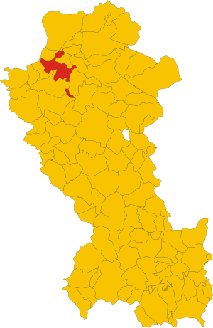
| Property / locator map image | |||||||||||||||
| Property / locator map image: Map of comune of Atella (province of Potenza, region Basilicata, Italy).svg / rank | |||||||||||||||
Normal rank | |||||||||||||||
| Property / locator map image: Map of comune of Atella (province of Potenza, region Basilicata, Italy).svg / reference | |||||||||||||||
| Property / local dialing code | |||||||||||||||
0972 | |||||||||||||||
| Property / local dialing code: 0972 / rank | |||||||||||||||
Normal rank | |||||||||||||||
| Property / local dialing code: 0972 / reference | |||||||||||||||
| Property / ISTAT ID | |||||||||||||||
076006 | |||||||||||||||
| Property / ISTAT ID: 076006 / rank | |||||||||||||||
Normal rank | |||||||||||||||
| Property / ISTAT ID: 076006 / reference | |||||||||||||||
| Property / coordinate location | |||||||||||||||
40°52'0"N, 15°39'0"E
| |||||||||||||||
| Property / coordinate location: 40°52'0"N, 15°39'0"E / rank | |||||||||||||||
Normal rank | |||||||||||||||
| Property / coordinate location: 40°52'0"N, 15°39'0"E / reference | |||||||||||||||
| Property / country | |||||||||||||||
| Property / country: Italy / rank | |||||||||||||||
Normal rank | |||||||||||||||
| Property / country: Italy / reference | |||||||||||||||
| Property / Italian cadastre code | |||||||||||||||
A482 | |||||||||||||||
| Property / Italian cadastre code: A482 / rank | |||||||||||||||
Normal rank | |||||||||||||||
| Property / Italian cadastre code: A482 / reference | |||||||||||||||
| Property / official website | |||||||||||||||
| Property / official website: http://www.comune.atella.pz.it/ / rank | |||||||||||||||
Normal rank | |||||||||||||||
| Property / official website: http://www.comune.atella.pz.it/ / reference | |||||||||||||||
| Property / Freebase ID | |||||||||||||||
| Property / Freebase ID: /m/062k_1 / rank | |||||||||||||||
Normal rank | |||||||||||||||
| Property / Freebase ID: /m/062k_1 / reference | |||||||||||||||
| Property / Freebase ID: /m/062k_1 / reference | |||||||||||||||
publication date: 28 October 2013
| |||||||||||||||
| Property / GeoNames ID | |||||||||||||||
| Property / GeoNames ID: 6541743 / rank | |||||||||||||||
Normal rank | |||||||||||||||
| Property / GeoNames ID: 6541743 / reference | |||||||||||||||
| Property / Digital Atlas of the Roman Empire ID | |||||||||||||||
| Property / Digital Atlas of the Roman Empire ID: 41800 / rank | |||||||||||||||
Normal rank | |||||||||||||||
| Property / elevation above sea level | |||||||||||||||
500±1 metre
| |||||||||||||||
| Property / elevation above sea level: 500±1 metre / rank | |||||||||||||||
Normal rank | |||||||||||||||
| Property / elevation above sea level: 500±1 metre / reference | |||||||||||||||
| Property / licence plate code | |||||||||||||||
PZ | |||||||||||||||
| Property / licence plate code: PZ / rank | |||||||||||||||
Normal rank | |||||||||||||||
| Property / coordinates of northernmost point | |||||||||||||||
40°57'0.594"N, 15°38'33.943"E
| |||||||||||||||
| Property / coordinates of northernmost point: 40°57'0.594"N, 15°38'33.943"E / rank | |||||||||||||||
Normal rank | |||||||||||||||
| Property / coordinates of northernmost point: 40°57'0.594"N, 15°38'33.943"E / reference | |||||||||||||||
| Property / coordinates of southernmost point | |||||||||||||||
40°46'10.232"N, 15°42'21.420"E
| |||||||||||||||
| Property / coordinates of southernmost point: 40°46'10.232"N, 15°42'21.420"E / rank | |||||||||||||||
Normal rank | |||||||||||||||
| Property / coordinates of southernmost point: 40°46'10.232"N, 15°42'21.420"E / reference | |||||||||||||||
| Property / coordinates of easternmost point | |||||||||||||||
40°53'7.483"N, 15°43'7.680"E
| |||||||||||||||
| Property / coordinates of easternmost point: 40°53'7.483"N, 15°43'7.680"E / rank | |||||||||||||||
Normal rank | |||||||||||||||
| Property / coordinates of easternmost point: 40°53'7.483"N, 15°43'7.680"E / reference | |||||||||||||||
| Property / coordinates of westernmost point | |||||||||||||||
40°55'11.060"N, 15°32'5.690"E
| |||||||||||||||
| Property / coordinates of westernmost point: 40°55'11.060"N, 15°32'5.690"E / rank | |||||||||||||||
Normal rank | |||||||||||||||
| Property / coordinates of westernmost point: 40°55'11.060"N, 15°32'5.690"E / reference | |||||||||||||||
| Property / OSM relation ID | |||||||||||||||
| Property / OSM relation ID: 40757 / rank | |||||||||||||||
Normal rank | |||||||||||||||
| Property / capital | |||||||||||||||
| Property / capital: Atella / rank | |||||||||||||||
Normal rank | |||||||||||||||
| Property / area | |||||||||||||||
88.48 square kilometre
| |||||||||||||||
| Property / area: 88.48 square kilometre / rank | |||||||||||||||
Normal rank | |||||||||||||||
| Property / area: 88.48 square kilometre / qualifier | |||||||||||||||
point in time: 9 October 2011
| |||||||||||||||
| Property / area: 88.48 square kilometre / reference | |||||||||||||||
| Property / area: 88.48 square kilometre / reference | |||||||||||||||
| Property / area: 88.48 square kilometre / reference | |||||||||||||||
title: Superficie di Comuni Province e Regioni italiane al 9 ottobre 2011 (Italian) | |||||||||||||||
| Property / area: 88.48 square kilometre / reference | |||||||||||||||
retrieved: 16 March 2019
| |||||||||||||||
| Property / area: 88.48 square kilometre / reference | |||||||||||||||
| Property / UN/LOCODE | |||||||||||||||
| Property / UN/LOCODE: ITAAP / rank | |||||||||||||||
Normal rank | |||||||||||||||
| Property / population | |||||||||||||||
3,860
| |||||||||||||||
| Property / population: 3,860 / rank | |||||||||||||||
Normal rank | |||||||||||||||
| Property / population: 3,860 / qualifier | |||||||||||||||
point in time: 1 January 2017
| |||||||||||||||
| Property / population: 3,860 / qualifier | |||||||||||||||
| Property / population: 3,860 / reference | |||||||||||||||
| Property / population | |||||||||||||||
3,829
| |||||||||||||||
| Property / population: 3,829 / rank | |||||||||||||||
Preferred rank | |||||||||||||||
| Property / population: 3,829 / qualifier | |||||||||||||||
point in time: 1 January 2018
| |||||||||||||||
| Property / population: 3,829 / qualifier | |||||||||||||||
| Property / population: 3,829 / reference | |||||||||||||||
| Property / population: 3,829 / reference | |||||||||||||||
title: Popolazione Residente al 1° Gennaio 2018 (Italian) | |||||||||||||||
| Property / population: 3,829 / reference | |||||||||||||||
retrieved: 16 March 2019
| |||||||||||||||
| Property / population: 3,829 / reference | |||||||||||||||
| Property / IndicePA ID | |||||||||||||||
| Property / IndicePA ID: c_a482 / rank | |||||||||||||||
Normal rank | |||||||||||||||
| Property / Who's on First ID | |||||||||||||||
| Property / Who's on First ID: 101800515 / rank | |||||||||||||||
Normal rank | |||||||||||||||
| Property / VIAF ID | |||||||||||||||
| Property / VIAF ID: 144323732 / rank | |||||||||||||||
Normal rank | |||||||||||||||
| Property / significant event | |||||||||||||||
| Property / significant event: Siege of Atella / rank | |||||||||||||||
Normal rank | |||||||||||||||
| Property / WorldCat Identities ID | |||||||||||||||
lccn-n85350159 | |||||||||||||||
| Property / WorldCat Identities ID: lccn-n85350159 / rank | |||||||||||||||
Normal rank | |||||||||||||||
| Property / WorldCat Identities ID: lccn-n85350159 / reference | |||||||||||||||
| Property / Wiki Loves Monuments ID | |||||||||||||||
17A4820000 | |||||||||||||||
| Property / Wiki Loves Monuments ID: 17A4820000 / rank | |||||||||||||||
Normal rank | |||||||||||||||
| Property / Wiki Loves Monuments ID: 17A4820000 / qualifier | |||||||||||||||
start time: 1 September 2020
| |||||||||||||||
| Property / Wiki Loves Monuments ID: 17A4820000 / reference | |||||||||||||||
| Property / topic's main category | |||||||||||||||
| Property / topic's main category: Category:Atella (comune, Italy) / rank | |||||||||||||||
Normal rank | |||||||||||||||
| Property / topic's main category: Category:Atella (comune, Italy) / reference | |||||||||||||||
| Property / category for people born here | |||||||||||||||
| Property / category for people born here: Q2599813 / rank | |||||||||||||||
Normal rank | |||||||||||||||
| Property / category for people born here: Q2599813 / reference | |||||||||||||||
| Property / category for people who died here | |||||||||||||||
| Property / category for people who died here: Q2599814 / rank | |||||||||||||||
Normal rank | |||||||||||||||
| Property / category for people who died here: Q2599814 / reference | |||||||||||||||
| Property / category of associated people | |||||||||||||||
| Property / category of associated people: Q2618391 / rank | |||||||||||||||
Normal rank | |||||||||||||||
| Property / category of associated people: Q2618391 / reference | |||||||||||||||
| Property / TGN ID | |||||||||||||||
| Property / TGN ID: 1043326 / rank | |||||||||||||||
Normal rank | |||||||||||||||
| Property / patron saint | |||||||||||||||
| Property / patron saint: Our Lady of the Snows / rank | |||||||||||||||
Normal rank | |||||||||||||||
| Property / patron saint: Our Lady of the Snows / reference | |||||||||||||||
| Property / patron saint: Our Lady of the Snows / reference | |||||||||||||||
| Property / seismic classification | |||||||||||||||
| Property / seismic classification: 1 / rank | |||||||||||||||
Normal rank | |||||||||||||||
| Property / seismic classification: 1 / reference | |||||||||||||||
| Property / seismic classification: 1 / reference | |||||||||||||||
| Property / seismic classification: 1 / reference | |||||||||||||||
retrieved: 27 August 2022
| |||||||||||||||
| Property / EU Knowledge Graph item ID | |||||||||||||||
Q296197 | |||||||||||||||
| Property / EU Knowledge Graph item ID: Q296197 / rank | |||||||||||||||
Normal rank | |||||||||||||||
| Property / coat of arms image | |||||||||||||||
| Property / coat of arms image: Atella-Stemma.svg / rank | |||||||||||||||
Normal rank | |||||||||||||||
| Property / image | |||||||||||||||
| Property / image: Mura di Atella (Porta San Michele).jpg / rank | |||||||||||||||
Normal rank | |||||||||||||||
| Property / image: Mura di Atella (Porta San Michele).jpg / reference | |||||||||||||||
| links / trwiki / name | links / trwiki / name | ||||||||||||||
Latest revision as of 10:52, 28 April 2023
Italian comune
- Atella
| Language | Label | Description | Also known as |
|---|---|---|---|
| English | Atella, Basilicata |
Italian comune |
|
Statements

.svg)
Map of comune of Atella (province of Potenza, region Basilicata, Italy).svg
2,713 × 4,168; 278 KB
2,713 × 4,168; 278 KB
1 reference
PZ
0 references


88.48 square kilometre
9 October 2011
5 references
Superficie di Comuni Province e Regioni italiane al 9 ottobre 2011 (Italian)
16 March 2019
3,860
1 January 2017
1 reference
3,829
1 January 2018
4 references
Popolazione Residente al 1° Gennaio 2018 (Italian)
16 March 2019

.jpg)
.svg)
.jpg)
Identifiers
85001130765
0 references
Q296197
0 references