Cinigiano (Q262962): Difference between revisions
Jump to navigation
Jump to search
(Changed label, description and/or aliases in 18 languages: The description in Wikidata changed) |
(Changed label, description and/or aliases in el: The description in Wikidata changed) |
||||||||||||||
| (19 intermediate revisions by 2 users not shown) | |||||||||||||||
| label / ga | label / ga | ||||||||||||||
Cinigiano | |||||||||||||||
| label / el | label / el | ||||||||||||||
Τσινιτζάνο | |||||||||||||||
| description / el | description / el | ||||||||||||||
δήμος | ιταλικός δήμος στην Επαρχία του Γκροσσέτο | ||||||||||||||
| Property / country | |||||||||||||||
| Property / country: Italy / rank | |||||||||||||||
| Property / instance of | |||||||||||||||
| Property / instance of: beneficiary / rank | |||||||||||||||
| Property / instance of | |||||||||||||||
| Property / instance of: commune of Italy / rank | |||||||||||||||
Normal rank | |||||||||||||||
| Property / instance of | |||||||||||||||
| Property / instance of: beneficiary / rank | |||||||||||||||
Preferred rank | |||||||||||||||
| Property / instance of | |||||||||||||||
| Property / instance of: public beneficiary / rank | |||||||||||||||
Normal rank | |||||||||||||||
| Property / instance of: public beneficiary / qualifier | |||||||||||||||
| Property / Commons category | |||||||||||||||
Cinigiano | |||||||||||||||
| Property / Commons category: Cinigiano / rank | |||||||||||||||
Normal rank | |||||||||||||||
| Property / located in the administrative territorial entity | |||||||||||||||
| Property / located in the administrative territorial entity: Province of Grosseto / rank | |||||||||||||||
Normal rank | |||||||||||||||
| Property / located in the administrative territorial entity: Province of Grosseto / reference | |||||||||||||||
| Property / postal code | |||||||||||||||
58044 | |||||||||||||||
| Property / postal code: 58044 / rank | |||||||||||||||
Normal rank | |||||||||||||||
| Property / postal code: 58044 / reference | |||||||||||||||
| Property / shares border with | |||||||||||||||
| Property / shares border with: Arcidosso / rank | |||||||||||||||
Normal rank | |||||||||||||||
| Property / shares border with: Arcidosso / reference | |||||||||||||||
| Property / shares border with | |||||||||||||||
| Property / shares border with: Castel del Piano / rank | |||||||||||||||
Normal rank | |||||||||||||||
| Property / shares border with: Castel del Piano / reference | |||||||||||||||
| Property / shares border with | |||||||||||||||
| Property / shares border with: Civitella Paganico / rank | |||||||||||||||
Normal rank | |||||||||||||||
| Property / shares border with: Civitella Paganico / reference | |||||||||||||||
| Property / shares border with | |||||||||||||||
| Property / shares border with: Montalcino / rank | |||||||||||||||
Normal rank | |||||||||||||||
| Property / shares border with: Montalcino / reference | |||||||||||||||
| Property / shares border with | |||||||||||||||
| Property / shares border with: Campagnatico / rank | |||||||||||||||
Normal rank | |||||||||||||||
| Property / shares border with: Campagnatico / reference | |||||||||||||||
| Property / located in time zone | |||||||||||||||
| Property / located in time zone: UTC+01:00 / rank | |||||||||||||||
Normal rank | |||||||||||||||
| Property / located in time zone: UTC+01:00 / qualifier | |||||||||||||||
| Property / located in time zone: UTC+01:00 / reference | |||||||||||||||
| Property / located in time zone | |||||||||||||||
| Property / located in time zone: UTC+02:00 / rank | |||||||||||||||
Normal rank | |||||||||||||||
| Property / located in time zone: UTC+02:00 / qualifier | |||||||||||||||
| Property / local dialing code | |||||||||||||||
0564 | |||||||||||||||
| Property / local dialing code: 0564 / rank | |||||||||||||||
Normal rank | |||||||||||||||
| Property / local dialing code: 0564 / reference | |||||||||||||||
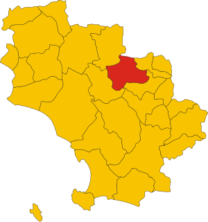
| Property / locator map image | |||||||||||||||
| Property / locator map image: Map of comune of Cinigiano (province of Grosseto, region Tuscany, Italy).svg / rank | |||||||||||||||
Normal rank | |||||||||||||||
| Property / locator map image: Map of comune of Cinigiano (province of Grosseto, region Tuscany, Italy).svg / reference | |||||||||||||||
| Property / image | |||||||||||||||
| Property / image: CinigianoPanorama.JPG / rank | |||||||||||||||
Normal rank | |||||||||||||||
| Property / ISTAT ID | |||||||||||||||
053007 | |||||||||||||||
| Property / ISTAT ID: 053007 / rank | |||||||||||||||
Normal rank | |||||||||||||||
| Property / ISTAT ID: 053007 / reference | |||||||||||||||
| Property / coordinate location | |||||||||||||||
42°53'26"N, 11°23'33"E
| |||||||||||||||
| Property / coordinate location: 42°53'26"N, 11°23'33"E / rank | |||||||||||||||
Normal rank | |||||||||||||||
| Property / coordinate location: 42°53'26"N, 11°23'33"E / reference | |||||||||||||||
| Property / country | |||||||||||||||
| Property / country: Italy / rank | |||||||||||||||
Normal rank | |||||||||||||||
| Property / country: Italy / reference | |||||||||||||||
| Property / Italian cadastre code | |||||||||||||||
C705 | |||||||||||||||
| Property / Italian cadastre code: C705 / rank | |||||||||||||||
Normal rank | |||||||||||||||
| Property / Italian cadastre code: C705 / reference | |||||||||||||||
| Property / official website | |||||||||||||||
| Property / official website: http://www.comune.cinigiano.gr.it/ / rank | |||||||||||||||
Normal rank | |||||||||||||||
| Property / official website: http://www.comune.cinigiano.gr.it/ / reference | |||||||||||||||
| Property / Freebase ID | |||||||||||||||
| Property / Freebase ID: /m/0gm1b4 / rank | |||||||||||||||
Normal rank | |||||||||||||||
| Property / Freebase ID: /m/0gm1b4 / reference | |||||||||||||||
| Property / Freebase ID: /m/0gm1b4 / reference | |||||||||||||||
publication date: 28 October 2013
| |||||||||||||||
| Property / GeoNames ID | |||||||||||||||
| Property / GeoNames ID: 6541105 / rank | |||||||||||||||
Normal rank | |||||||||||||||
| Property / GeoNames ID: 6541105 / reference | |||||||||||||||
| Property / GND ID | |||||||||||||||
| Property / GND ID: 4643158-5 / rank | |||||||||||||||
Normal rank | |||||||||||||||
| Property / GND ID: 4643158-5 / reference | |||||||||||||||
| Property / category for people who died here | |||||||||||||||
| Property / category for people who died here: Category:Deaths in Cinigiano / rank | |||||||||||||||
Normal rank | |||||||||||||||
| Property / category for people who died here: Category:Deaths in Cinigiano / reference | |||||||||||||||
| Property / category for people born here | |||||||||||||||
| Property / category for people born here: Q2609956 / rank | |||||||||||||||
Normal rank | |||||||||||||||
| Property / category for people born here: Q2609956 / reference | |||||||||||||||
| Property / topic's main category | |||||||||||||||
| Property / topic's main category: Category:Cinigiano / rank | |||||||||||||||
Normal rank | |||||||||||||||
| Property / topic's main category: Category:Cinigiano / reference | |||||||||||||||
| Property / VIAF ID | |||||||||||||||
| Property / VIAF ID: 245843049 / rank | |||||||||||||||
Normal rank | |||||||||||||||
| Property / VIAF ID: 245843049 / reference | |||||||||||||||
| Property / VIAF ID: 245843049 / reference | |||||||||||||||
retrieved: 3 August 2015
| |||||||||||||||
| Property / elevation above sea level | |||||||||||||||
324±1 metre
| |||||||||||||||
| Property / elevation above sea level: 324±1 metre / rank | |||||||||||||||
Normal rank | |||||||||||||||
| Property / elevation above sea level: 324±1 metre / reference | |||||||||||||||
| Property / licence plate code | |||||||||||||||
GR | |||||||||||||||
| Property / licence plate code: GR / rank | |||||||||||||||
Normal rank | |||||||||||||||
| Property / coordinates of northernmost point | |||||||||||||||
42°58'19.258"N, 11°21'1.408"E
| |||||||||||||||
| Property / coordinates of northernmost point: 42°58'19.258"N, 11°21'1.408"E / rank | |||||||||||||||
Normal rank | |||||||||||||||
| Property / coordinates of northernmost point: 42°58'19.258"N, 11°21'1.408"E / reference | |||||||||||||||
| Property / coordinates of southernmost point | |||||||||||||||
42°49'51.064"N, 11°20'13.884"E
| |||||||||||||||
| Property / coordinates of southernmost point: 42°49'51.064"N, 11°20'13.884"E / rank | |||||||||||||||
Normal rank | |||||||||||||||
| Property / coordinates of southernmost point: 42°49'51.064"N, 11°20'13.884"E / reference | |||||||||||||||
| Property / coordinates of easternmost point | |||||||||||||||
42°52'58.922"N, 11°30'15.797"E
| |||||||||||||||
| Property / coordinates of easternmost point: 42°52'58.922"N, 11°30'15.797"E / rank | |||||||||||||||
Normal rank | |||||||||||||||
| Property / coordinates of easternmost point: 42°52'58.922"N, 11°30'15.797"E / reference | |||||||||||||||
| Property / coordinates of westernmost point | |||||||||||||||
42°55'46.967"N, 11°16'15.665"E
| |||||||||||||||
| Property / coordinates of westernmost point: 42°55'46.967"N, 11°16'15.665"E / rank | |||||||||||||||
Normal rank | |||||||||||||||
| Property / coordinates of westernmost point: 42°55'46.967"N, 11°16'15.665"E / reference | |||||||||||||||
| Property / OSM relation ID | |||||||||||||||
| Property / OSM relation ID: 42230 / rank | |||||||||||||||
Normal rank | |||||||||||||||
| Property / UN/LOCODE | |||||||||||||||
| Property / UN/LOCODE: ITCQO / rank | |||||||||||||||
Normal rank | |||||||||||||||
| Property / capital | |||||||||||||||
| Property / capital: Cinigiano / rank | |||||||||||||||
Normal rank | |||||||||||||||
| Property / area | |||||||||||||||
161.55 square kilometre
| |||||||||||||||
| Property / area: 161.55 square kilometre / rank | |||||||||||||||
Normal rank | |||||||||||||||
| Property / area: 161.55 square kilometre / qualifier | |||||||||||||||
point in time: 9 October 2011
| |||||||||||||||
| Property / area: 161.55 square kilometre / reference | |||||||||||||||
| Property / area: 161.55 square kilometre / reference | |||||||||||||||
| Property / area: 161.55 square kilometre / reference | |||||||||||||||
title: Superficie di Comuni Province e Regioni italiane al 9 ottobre 2011 (Italian) | |||||||||||||||
| Property / area: 161.55 square kilometre / reference | |||||||||||||||
retrieved: 16 March 2019
| |||||||||||||||
| Property / area: 161.55 square kilometre / reference | |||||||||||||||
| Property / population | |||||||||||||||
2,580
| |||||||||||||||
| Property / population: 2,580 / rank | |||||||||||||||
Normal rank | |||||||||||||||
| Property / population: 2,580 / qualifier | |||||||||||||||
point in time: 1 January 2017
| |||||||||||||||
| Property / population: 2,580 / qualifier | |||||||||||||||
| Property / population: 2,580 / reference | |||||||||||||||
| Property / population | |||||||||||||||
2,536
| |||||||||||||||
| Property / population: 2,536 / rank | |||||||||||||||
Preferred rank | |||||||||||||||
| Property / population: 2,536 / qualifier | |||||||||||||||
point in time: 1 January 2018
| |||||||||||||||
| Property / population: 2,536 / qualifier | |||||||||||||||
| Property / population: 2,536 / reference | |||||||||||||||
| Property / population: 2,536 / reference | |||||||||||||||
title: Popolazione Residente al 1° Gennaio 2018 (Italian) | |||||||||||||||
| Property / population: 2,536 / reference | |||||||||||||||
retrieved: 16 March 2019
| |||||||||||||||
| Property / population: 2,536 / reference | |||||||||||||||
| Property / IndicePA ID | |||||||||||||||
| Property / IndicePA ID: c_c705 / rank | |||||||||||||||
Normal rank | |||||||||||||||
| Property / Who's on First ID | |||||||||||||||
| Property / Who's on First ID: 101800075 / rank | |||||||||||||||
Normal rank | |||||||||||||||
| Property / WorldCat Identities ID | |||||||||||||||
viaf-245843049 | |||||||||||||||
| Property / WorldCat Identities ID: viaf-245843049 / rank | |||||||||||||||
Normal rank | |||||||||||||||
| Property / WorldCat Identities ID: viaf-245843049 / reference | |||||||||||||||
| Property / Wiki Loves Monuments ID | |||||||||||||||
09C7050000 | |||||||||||||||
| Property / Wiki Loves Monuments ID: 09C7050000 / rank | |||||||||||||||
Normal rank | |||||||||||||||
| Property / Wiki Loves Monuments ID: 09C7050000 / qualifier | |||||||||||||||
start time: 1 September 2020
| |||||||||||||||
| Property / Wiki Loves Monuments ID: 09C7050000 / reference | |||||||||||||||
| Property / patron saint | |||||||||||||||
| Property / patron saint: Michael / rank | |||||||||||||||
Normal rank | |||||||||||||||
| Property / patron saint: Michael / reference | |||||||||||||||
| Property / patron saint: Michael / reference | |||||||||||||||
| Property / twinned administrative body | |||||||||||||||
| Property / twinned administrative body: Montcuq-en-Quercy-Blanc / rank | |||||||||||||||
Normal rank | |||||||||||||||
| Property / Repetti on-line ID | |||||||||||||||
1315 | |||||||||||||||
| Property / Repetti on-line ID: 1315 / rank | |||||||||||||||
Normal rank | |||||||||||||||
| Property / office held by head of government | |||||||||||||||
| Property / office held by head of government: mayor of Cinigiano / rank | |||||||||||||||
Normal rank | |||||||||||||||
| Property / seismic classification | |||||||||||||||
| Property / seismic classification: 3 / rank | |||||||||||||||
Normal rank | |||||||||||||||
| Property / seismic classification: 3 / reference | |||||||||||||||
| Property / seismic classification: 3 / reference | |||||||||||||||
| Property / seismic classification: 3 / reference | |||||||||||||||
retrieved: 27 August 2022
| |||||||||||||||
| Property / EU Knowledge Graph item ID | |||||||||||||||
Q262962 | |||||||||||||||
| Property / EU Knowledge Graph item ID: Q262962 / rank | |||||||||||||||
Normal rank | |||||||||||||||
| links / bgwiki / name | links / bgwiki / name | ||||||||||||||
| links / dewiki / name | links / dewiki / name | ||||||||||||||
| links / enwiki / name | links / enwiki / name | ||||||||||||||
| links / eswiki / name | links / eswiki / name | ||||||||||||||
| links / frwiki / name | links / frwiki / name | ||||||||||||||
| links / huwiki / name | links / huwiki / name | ||||||||||||||
| links / itwiki / name | links / itwiki / name | ||||||||||||||
| links / nlwiki / name | links / nlwiki / name | ||||||||||||||
| links / plwiki / name | links / plwiki / name | ||||||||||||||
| links / ptwiki / name | links / ptwiki / name | ||||||||||||||
| links / rowiki / name | links / rowiki / name | ||||||||||||||
| links / svwiki / name | links / svwiki / name | ||||||||||||||
| links / trwiki / name | links / trwiki / name | ||||||||||||||
Latest revision as of 22:29, 7 February 2023
Italian comune
| Language | Label | Description | Also known as |
|---|---|---|---|
| English | Cinigiano |
Italian comune |
Statements

Cinigiano
0 references
.svg)
Map of comune of Cinigiano (province of Grosseto, region Tuscany, Italy).svg
3,918 × 4,187; 97 KB
3,918 × 4,187; 97 KB
1 reference

GR
0 references


.svg)
161.55 square kilometre
9 October 2011
5 references
Superficie di Comuni Province e Regioni italiane al 9 ottobre 2011 (Italian)
16 March 2019
2,580
1 January 2017
1 reference
2,536
1 January 2018
4 references
Popolazione Residente al 1° Gennaio 2018 (Italian)
16 March 2019
Identifiers
117340539
0 references
1315
0 references
Q262962
0 references