Frisa (Q277986): Difference between revisions
Jump to navigation
Jump to search
(Changed an Item: Sitelinks in wikidata changed) |
(Changed an Item: Adding these statements since they where added in Wikidata) |
||||||||||||||
| (17 intermediate revisions by 2 users not shown) | |||||||||||||||
| label / tr | label / tr | ||||||||||||||
Frisa, Abruzzo | |||||||||||||||
| label / ga | label / ga | ||||||||||||||
Frisa | |||||||||||||||
| description / hu | description / hu | ||||||||||||||
község (comune) Olaszország Abruzzo régiójában | |||||||||||||||
| Property / country | |||||||||||||||
| Property / country: Italy / rank | |||||||||||||||
| Property / instance of | |||||||||||||||
| Property / instance of: beneficiary / rank | |||||||||||||||
| Property / instance of | |||||||||||||||
| Property / instance of: commune of Italy / rank | |||||||||||||||
Normal rank | |||||||||||||||
| Property / instance of | |||||||||||||||
| Property / instance of: beneficiary / rank | |||||||||||||||
Preferred rank | |||||||||||||||
| Property / instance of | |||||||||||||||
| Property / instance of: public beneficiary / rank | |||||||||||||||
Normal rank | |||||||||||||||
| Property / instance of: public beneficiary / qualifier | |||||||||||||||
| Property / Commons category | |||||||||||||||
Frisa | |||||||||||||||
| Property / Commons category: Frisa / rank | |||||||||||||||
Normal rank | |||||||||||||||
| Property / located in the administrative territorial entity | |||||||||||||||
| Property / located in the administrative territorial entity: Province of Chieti / rank | |||||||||||||||
Normal rank | |||||||||||||||
| Property / located in the administrative territorial entity: Province of Chieti / reference | |||||||||||||||
| Property / postal code | |||||||||||||||
66030 | |||||||||||||||
| Property / postal code: 66030 / rank | |||||||||||||||
Normal rank | |||||||||||||||
| Property / postal code: 66030 / reference | |||||||||||||||
| Property / shares border with | |||||||||||||||
| Property / shares border with: Lanciano / rank | |||||||||||||||
Normal rank | |||||||||||||||
| Property / shares border with: Lanciano / reference | |||||||||||||||
| Property / shares border with | |||||||||||||||
| Property / shares border with: Poggiofiorito / rank | |||||||||||||||
Normal rank | |||||||||||||||
| Property / shares border with: Poggiofiorito / reference | |||||||||||||||
| Property / shares border with | |||||||||||||||
| Property / shares border with: Crecchio / rank | |||||||||||||||
Normal rank | |||||||||||||||
| Property / shares border with | |||||||||||||||
| Property / shares border with: Ortona / rank | |||||||||||||||
Normal rank | |||||||||||||||
| Property / shares border with | |||||||||||||||
| Property / shares border with: San Vito Chietino / rank | |||||||||||||||
Normal rank | |||||||||||||||
| Property / located in time zone | |||||||||||||||
| Property / located in time zone: UTC+01:00 / rank | |||||||||||||||
Normal rank | |||||||||||||||
| Property / located in time zone: UTC+01:00 / qualifier | |||||||||||||||
| Property / located in time zone: UTC+01:00 / reference | |||||||||||||||
| Property / located in time zone | |||||||||||||||
| Property / located in time zone: UTC+02:00 / rank | |||||||||||||||
Normal rank | |||||||||||||||
| Property / located in time zone: UTC+02:00 / qualifier | |||||||||||||||
| Property / locator map image | |||||||||||||||
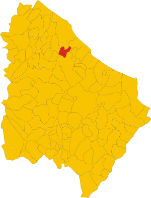
| Property / locator map image: Map of comune of Frisa (province of Chieti, region Abruzzo, Italy).svg / rank | |||||||||||||||
Normal rank | |||||||||||||||
| Property / locator map image: Map of comune of Frisa (province of Chieti, region Abruzzo, Italy).svg / reference | |||||||||||||||
| Property / local dialing code | |||||||||||||||
0872 | |||||||||||||||
| Property / local dialing code: 0872 / rank | |||||||||||||||
Normal rank | |||||||||||||||
| Property / local dialing code: 0872 / reference | |||||||||||||||
| Property / ISTAT ID | |||||||||||||||
069037 | |||||||||||||||
| Property / ISTAT ID: 069037 / rank | |||||||||||||||
Normal rank | |||||||||||||||
| Property / ISTAT ID: 069037 / reference | |||||||||||||||
| Property / coordinate location | |||||||||||||||
42°16'0"N, 14°22'0"E
| |||||||||||||||
| Property / coordinate location: 42°16'0"N, 14°22'0"E / rank | |||||||||||||||
Normal rank | |||||||||||||||
| Property / coordinate location: 42°16'0"N, 14°22'0"E / reference | |||||||||||||||
| Property / country | |||||||||||||||
| Property / country: Italy / rank | |||||||||||||||
Normal rank | |||||||||||||||
| Property / country: Italy / reference | |||||||||||||||
| Property / Italian cadastre code | |||||||||||||||
D803 | |||||||||||||||
| Property / Italian cadastre code: D803 / rank | |||||||||||||||
Normal rank | |||||||||||||||
| Property / Italian cadastre code: D803 / reference | |||||||||||||||
| Property / GeoNames ID | |||||||||||||||
| Property / GeoNames ID: 6541227 / rank | |||||||||||||||
Normal rank | |||||||||||||||
| Property / GeoNames ID: 6541227 / reference | |||||||||||||||
| Property / topic's main category | |||||||||||||||
| Property / topic's main category: Category:Frisa / rank | |||||||||||||||
Normal rank | |||||||||||||||
| Property / topic's main category: Category:Frisa / reference | |||||||||||||||
| Property / VIAF ID | |||||||||||||||
| Property / VIAF ID: 233917238 / rank | |||||||||||||||
Normal rank | |||||||||||||||
| Property / VIAF ID: 233917238 / reference | |||||||||||||||
| Property / VIAF ID: 233917238 / reference | |||||||||||||||
retrieved: 2 August 2015
| |||||||||||||||
| Property / elevation above sea level | |||||||||||||||
237±1 metre
| |||||||||||||||
| Property / elevation above sea level: 237±1 metre / rank | |||||||||||||||
Normal rank | |||||||||||||||
| Property / elevation above sea level: 237±1 metre / reference | |||||||||||||||
| Property / official website | |||||||||||||||
| Property / official website: http://www.comune.frisa.ch.it/ / rank | |||||||||||||||
Normal rank | |||||||||||||||
| Property / official website: http://www.comune.frisa.ch.it/ / reference | |||||||||||||||
| Property / Freebase ID | |||||||||||||||
| Property / Freebase ID: /m/0fg2ft / rank | |||||||||||||||
Normal rank | |||||||||||||||
| Property / licence plate code | |||||||||||||||
CH | |||||||||||||||
| Property / licence plate code: CH / rank | |||||||||||||||
Normal rank | |||||||||||||||
| Property / coordinates of northernmost point | |||||||||||||||
42°17'12.606"N, 14°24'3.460"E
| |||||||||||||||
| Property / coordinates of northernmost point: 42°17'12.606"N, 14°24'3.460"E / rank | |||||||||||||||
Normal rank | |||||||||||||||
| Property / coordinates of northernmost point: 42°17'12.606"N, 14°24'3.460"E / reference | |||||||||||||||
| Property / coordinates of southernmost point | |||||||||||||||
42°14'43.793"N, 14°22'45.674"E
| |||||||||||||||
| Property / coordinates of southernmost point: 42°14'43.793"N, 14°22'45.674"E / rank | |||||||||||||||
Normal rank | |||||||||||||||
| Property / coordinates of southernmost point: 42°14'43.793"N, 14°22'45.674"E / reference | |||||||||||||||
| Property / coordinates of easternmost point | |||||||||||||||
42°16'48.637"N, 14°24'40.536"E
| |||||||||||||||
| Property / coordinates of easternmost point: 42°16'48.637"N, 14°24'40.536"E / rank | |||||||||||||||
Normal rank | |||||||||||||||
| Property / coordinates of easternmost point: 42°16'48.637"N, 14°24'40.536"E / reference | |||||||||||||||
| Property / coordinates of westernmost point | |||||||||||||||
42°15'35.690"N, 14°21'4.565"E
| |||||||||||||||
| Property / coordinates of westernmost point: 42°15'35.690"N, 14°21'4.565"E / rank | |||||||||||||||
Normal rank | |||||||||||||||
| Property / coordinates of westernmost point: 42°15'35.690"N, 14°21'4.565"E / reference | |||||||||||||||
| Property / OSM relation ID | |||||||||||||||
| Property / OSM relation ID: 41906 / rank | |||||||||||||||
Normal rank | |||||||||||||||
| Property / capital | |||||||||||||||
| Property / capital: Frisa / rank | |||||||||||||||
Normal rank | |||||||||||||||
| Property / area | |||||||||||||||
11.49 square kilometre
| |||||||||||||||
| Property / area: 11.49 square kilometre / rank | |||||||||||||||
Normal rank | |||||||||||||||
| Property / area: 11.49 square kilometre / qualifier | |||||||||||||||
point in time: 9 October 2011
| |||||||||||||||
| Property / area: 11.49 square kilometre / reference | |||||||||||||||
| Property / area: 11.49 square kilometre / reference | |||||||||||||||
| Property / area: 11.49 square kilometre / reference | |||||||||||||||
title: Superficie di Comuni Province e Regioni italiane al 9 ottobre 2011 (Italian) | |||||||||||||||
| Property / area: 11.49 square kilometre / reference | |||||||||||||||
retrieved: 16 March 2019
| |||||||||||||||
| Property / area: 11.49 square kilometre / reference | |||||||||||||||
| Property / population | |||||||||||||||
1,737
| |||||||||||||||
| Property / population: 1,737 / rank | |||||||||||||||
Normal rank | |||||||||||||||
| Property / population: 1,737 / qualifier | |||||||||||||||
point in time: 1 January 2017
| |||||||||||||||
| Property / population: 1,737 / qualifier | |||||||||||||||
point in time: 1 January 2018
| |||||||||||||||
| Property / population: 1,737 / qualifier | |||||||||||||||
| Property / population: 1,737 / reference | |||||||||||||||
| Property / population: 1,737 / reference | |||||||||||||||
| Property / population: 1,737 / reference | |||||||||||||||
title: Popolazione Residente al 1° Gennaio 2018 (Italian) | |||||||||||||||
| Property / population: 1,737 / reference | |||||||||||||||
retrieved: 16 March 2019
| |||||||||||||||
| Property / population: 1,737 / reference | |||||||||||||||
| Property / population | |||||||||||||||
999
| |||||||||||||||
| Property / population: 999 / rank | |||||||||||||||
Normal rank | |||||||||||||||
| Property / population: 999 / qualifier | |||||||||||||||
point in time: 1 January 2018
| |||||||||||||||
| Property / population: 999 / qualifier | |||||||||||||||
| Property / population: 999 / reference | |||||||||||||||
| Property / population: 999 / reference | |||||||||||||||
title: Popolazione Residente al 1° Gennaio 2018 (Italian) | |||||||||||||||
| Property / population: 999 / reference | |||||||||||||||
retrieved: 16 March 2019
| |||||||||||||||
| Property / population: 999 / reference | |||||||||||||||
| Property / IndicePA ID | |||||||||||||||
| Property / IndicePA ID: c_d803 / rank | |||||||||||||||
Normal rank | |||||||||||||||
| Property / Who's on First ID | |||||||||||||||
| Property / Who's on First ID: 101799653 / rank | |||||||||||||||
Normal rank | |||||||||||||||
| Property / WorldCat Identities ID | |||||||||||||||
viaf-233917238 | |||||||||||||||
| Property / WorldCat Identities ID: viaf-233917238 / rank | |||||||||||||||
Normal rank | |||||||||||||||
| Property / WorldCat Identities ID: viaf-233917238 / reference | |||||||||||||||
| Property / Wiki Loves Monuments ID | |||||||||||||||
13D8030000 | |||||||||||||||
| Property / Wiki Loves Monuments ID: 13D8030000 / rank | |||||||||||||||
Normal rank | |||||||||||||||
| Property / Wiki Loves Monuments ID: 13D8030000 / qualifier | |||||||||||||||
start time: 1 September 2020
| |||||||||||||||
| Property / Wiki Loves Monuments ID: 13D8030000 / reference | |||||||||||||||
| Property / De Agostini ID | |||||||||||||||
| Property / De Agostini ID: Frisa / rank | |||||||||||||||
Normal rank | |||||||||||||||
| Property / De Agostini ID: Frisa / qualifier | |||||||||||||||
named as: Frisa | |||||||||||||||
| Property / patron saint | |||||||||||||||
| Property / patron saint: Pantaleon / rank | |||||||||||||||
Normal rank | |||||||||||||||
| Property / patron saint: Pantaleon / reference | |||||||||||||||
| Property / patron saint: Pantaleon / reference | |||||||||||||||
| Property / seismic classification | |||||||||||||||
| Property / seismic classification: 3 / rank | |||||||||||||||
Normal rank | |||||||||||||||
| Property / seismic classification: 3 / reference | |||||||||||||||
| Property / seismic classification: 3 / reference | |||||||||||||||
| Property / seismic classification: 3 / reference | |||||||||||||||
retrieved: 27 August 2022
| |||||||||||||||
| Property / EU Knowledge Graph item ID | |||||||||||||||
Q277986 | |||||||||||||||
| Property / EU Knowledge Graph item ID: Q277986 / rank | |||||||||||||||
Normal rank | |||||||||||||||
| links / trwiki / name | links / trwiki / name | ||||||||||||||
Latest revision as of 19:11, 29 December 2022
Italian comune
| Language | Label | Description | Also known as |
|---|---|---|---|
| English | Frisa |
Italian comune |
Statements

Frisa
0 references
.svg)
Map of comune of Frisa (province of Chieti, region Abruzzo, Italy).svg
2,502 × 3,273; 158 KB
2,502 × 3,273; 158 KB
1 reference
CH
0 references


.svg)
11.49 square kilometre
9 October 2011
5 references
Superficie di Comuni Province e Regioni italiane al 9 ottobre 2011 (Italian)
16 March 2019
1,737
1 January 2017
1 January 2018
5 references
Popolazione Residente al 1° Gennaio 2018 (Italian)
16 March 2019
999
1 January 2018
4 references
Popolazione Residente al 1° Gennaio 2018 (Italian)
16 March 2019
Identifiers
00249480690
0 references
Q277986
0 references