Cerenzia (Q275949): Difference between revisions
Jump to navigation
Jump to search
(Changed label, description and/or aliases in 17 languages: The description in Wikidata changed) |
(Changed an Item: Adding these statements since they where added in Wikidata) |
||||||||||||||
| (17 intermediate revisions by 2 users not shown) | |||||||||||||||
| label / tr | label / tr | ||||||||||||||
Cerenzia | |||||||||||||||
| label / ga | label / ga | ||||||||||||||
Cerenzia | |||||||||||||||
| description / hu | description / hu | ||||||||||||||
község Olaszországban | |||||||||||||||
| Property / country | |||||||||||||||
| Property / country: Italy / rank | |||||||||||||||
| Property / instance of | |||||||||||||||
| Property / instance of: beneficiary / rank | |||||||||||||||
| Property / instance of | |||||||||||||||
| Property / instance of: commune of Italy / rank | |||||||||||||||
Normal rank | |||||||||||||||
| Property / instance of | |||||||||||||||
| Property / instance of: beneficiary / rank | |||||||||||||||
Preferred rank | |||||||||||||||
| Property / instance of | |||||||||||||||
| Property / instance of: public beneficiary / rank | |||||||||||||||
Normal rank | |||||||||||||||
| Property / instance of: public beneficiary / qualifier | |||||||||||||||
| Property / Commons category | |||||||||||||||
Cerenzia | |||||||||||||||
| Property / Commons category: Cerenzia / rank | |||||||||||||||
Normal rank | |||||||||||||||
| Property / located in the administrative territorial entity | |||||||||||||||
| Property / located in the administrative territorial entity: Province of Crotone / rank | |||||||||||||||
Normal rank | |||||||||||||||
| Property / located in the administrative territorial entity: Province of Crotone / reference | |||||||||||||||
| Property / postal code | |||||||||||||||
88833 | |||||||||||||||
| Property / postal code: 88833 / rank | |||||||||||||||
Normal rank | |||||||||||||||
| Property / postal code: 88833 / reference | |||||||||||||||
| Property / shares border with | |||||||||||||||
| Property / shares border with: Caccuri / rank | |||||||||||||||
Normal rank | |||||||||||||||
| Property / shares border with: Caccuri / reference | |||||||||||||||
| Property / shares border with | |||||||||||||||
| Property / shares border with: Castelsilano / rank | |||||||||||||||
Normal rank | |||||||||||||||
| Property / shares border with: Castelsilano / reference | |||||||||||||||
| Property / shares border with | |||||||||||||||
| Property / shares border with: San Giovanni in Fiore / rank | |||||||||||||||
Normal rank | |||||||||||||||
| Property / patron saint | |||||||||||||||
| Property / patron saint: Theodore of Amasea / rank | |||||||||||||||
Normal rank | |||||||||||||||
| Property / patron saint: Theodore of Amasea / reference | |||||||||||||||
| Property / local dialing code | |||||||||||||||
0984 | |||||||||||||||
| Property / local dialing code: 0984 / rank | |||||||||||||||
Normal rank | |||||||||||||||
| Property / local dialing code: 0984 / reference | |||||||||||||||
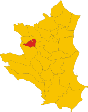
| Property / locator map image | |||||||||||||||
| Property / locator map image: Map of comune of Cerenzia (province of Crotone, region Calabria, Italy).svg / rank | |||||||||||||||
Normal rank | |||||||||||||||
| Property / locator map image: Map of comune of Cerenzia (province of Crotone, region Calabria, Italy).svg / reference | |||||||||||||||
| Property / ISTAT ID | |||||||||||||||
101006 | |||||||||||||||
| Property / ISTAT ID: 101006 / rank | |||||||||||||||
Normal rank | |||||||||||||||
| Property / ISTAT ID: 101006 / reference | |||||||||||||||
| Property / coordinate location | |||||||||||||||
39°15'0"N, 16°47'0"E
| |||||||||||||||
| Property / coordinate location: 39°15'0"N, 16°47'0"E / rank | |||||||||||||||
Normal rank | |||||||||||||||
| Property / coordinate location: 39°15'0"N, 16°47'0"E / reference | |||||||||||||||
| Property / country | |||||||||||||||
| Property / country: Italy / rank | |||||||||||||||
Normal rank | |||||||||||||||
| Property / country: Italy / reference | |||||||||||||||
| Property / Italian cadastre code | |||||||||||||||
C501 | |||||||||||||||
| Property / Italian cadastre code: C501 / rank | |||||||||||||||
Normal rank | |||||||||||||||
| Property / Italian cadastre code: C501 / reference | |||||||||||||||
| Property / located in time zone | |||||||||||||||
| Property / located in time zone: UTC+01:00 / rank | |||||||||||||||
Normal rank | |||||||||||||||
| Property / located in time zone: UTC+01:00 / qualifier | |||||||||||||||
| Property / located in time zone: UTC+01:00 / reference | |||||||||||||||
| Property / located in time zone | |||||||||||||||
| Property / located in time zone: UTC+02:00 / rank | |||||||||||||||
Normal rank | |||||||||||||||
| Property / located in time zone: UTC+02:00 / qualifier | |||||||||||||||
| Property / Freebase ID | |||||||||||||||
| Property / Freebase ID: /m/0fk1s6 / rank | |||||||||||||||
Normal rank | |||||||||||||||
| Property / Freebase ID: /m/0fk1s6 / reference | |||||||||||||||
| Property / Freebase ID: /m/0fk1s6 / reference | |||||||||||||||
publication date: 28 October 2013
| |||||||||||||||
| Property / GeoNames ID | |||||||||||||||
| Property / GeoNames ID: 6539424 / rank | |||||||||||||||
Normal rank | |||||||||||||||
| Property / GeoNames ID: 6539424 / reference | |||||||||||||||
| Property / category for people born here | |||||||||||||||
| Property / category for people born here: Q2583686 / rank | |||||||||||||||
Normal rank | |||||||||||||||
| Property / category for people born here: Q2583686 / reference | |||||||||||||||
| Property / topic's main category | |||||||||||||||
| Property / topic's main category: Category:Cerenzia / rank | |||||||||||||||
Normal rank | |||||||||||||||
| Property / topic's main category: Category:Cerenzia / reference | |||||||||||||||
| Property / elevation above sea level | |||||||||||||||
900±1 metre
| |||||||||||||||
| Property / elevation above sea level: 900±1 metre / rank | |||||||||||||||
Normal rank | |||||||||||||||
| Property / elevation above sea level: 900±1 metre / reference | |||||||||||||||
| Property / TGN ID | |||||||||||||||
| Property / TGN ID: 7024893 / rank | |||||||||||||||
Normal rank | |||||||||||||||
| Property / licence plate code | |||||||||||||||
KR | |||||||||||||||
| Property / licence plate code: KR / rank | |||||||||||||||
Normal rank | |||||||||||||||
| Property / official website | |||||||||||||||
| Property / official website: http://cerenzia.asmenet.it/ / rank | |||||||||||||||
Normal rank | |||||||||||||||
| Property / official website: http://cerenzia.asmenet.it/ / reference | |||||||||||||||
| Property / coordinates of northernmost point | |||||||||||||||
39°16'48.994"N, 16°50'16.192"E
| |||||||||||||||
| Property / coordinates of northernmost point: 39°16'48.994"N, 16°50'16.192"E / rank | |||||||||||||||
Normal rank | |||||||||||||||
| Property / coordinates of northernmost point: 39°16'48.994"N, 16°50'16.192"E / reference | |||||||||||||||
| Property / coordinates of southernmost point | |||||||||||||||
39°14'0.413"N, 16°49'3.184"E
| |||||||||||||||
| Property / coordinates of southernmost point: 39°14'0.413"N, 16°49'3.184"E / rank | |||||||||||||||
Normal rank | |||||||||||||||
| Property / coordinates of southernmost point: 39°14'0.413"N, 16°49'3.184"E / reference | |||||||||||||||
| Property / coordinates of easternmost point | |||||||||||||||
39°15'51.944"N, 16°51'21.337"E
| |||||||||||||||
| Property / coordinates of easternmost point: 39°15'51.944"N, 16°51'21.337"E / rank | |||||||||||||||
Normal rank | |||||||||||||||
| Property / coordinates of easternmost point: 39°15'51.944"N, 16°51'21.337"E / reference | |||||||||||||||
| Property / coordinates of westernmost point | |||||||||||||||
39°14'53.639"N, 16°46'4.577"E
| |||||||||||||||
| Property / coordinates of westernmost point: 39°14'53.639"N, 16°46'4.577"E / rank | |||||||||||||||
Normal rank | |||||||||||||||
| Property / coordinates of westernmost point: 39°14'53.639"N, 16°46'4.577"E / reference | |||||||||||||||
| Property / OSM relation ID | |||||||||||||||
| Property / OSM relation ID: 39862 / rank | |||||||||||||||
Normal rank | |||||||||||||||
| Property / image | |||||||||||||||
| Property / image: Cerenzia.jpeg / rank | |||||||||||||||
Normal rank | |||||||||||||||
| Property / image: Cerenzia.jpeg / reference | |||||||||||||||
| Property / capital | |||||||||||||||
| Property / capital: Cerenzia / rank | |||||||||||||||
Normal rank | |||||||||||||||
| Property / area | |||||||||||||||
21.97 square kilometre
| |||||||||||||||
| Property / area: 21.97 square kilometre / rank | |||||||||||||||
Normal rank | |||||||||||||||
| Property / area: 21.97 square kilometre / qualifier | |||||||||||||||
point in time: 9 October 2011
| |||||||||||||||
| Property / area: 21.97 square kilometre / reference | |||||||||||||||
| Property / area: 21.97 square kilometre / reference | |||||||||||||||
| Property / area: 21.97 square kilometre / reference | |||||||||||||||
title: Superficie di Comuni Province e Regioni italiane al 9 ottobre 2011 (Italian) | |||||||||||||||
| Property / area: 21.97 square kilometre / reference | |||||||||||||||
retrieved: 16 March 2019
| |||||||||||||||
| Property / area: 21.97 square kilometre / reference | |||||||||||||||
| Property / population | |||||||||||||||
1,147
| |||||||||||||||
| Property / population: 1,147 / rank | |||||||||||||||
Normal rank | |||||||||||||||
| Property / population: 1,147 / qualifier | |||||||||||||||
point in time: 1 January 2017
| |||||||||||||||
| Property / population: 1,147 / qualifier | |||||||||||||||
| Property / population: 1,147 / reference | |||||||||||||||
| Property / population | |||||||||||||||
1,123
| |||||||||||||||
| Property / population: 1,123 / rank | |||||||||||||||
Preferred rank | |||||||||||||||
| Property / population: 1,123 / qualifier | |||||||||||||||
point in time: 1 January 2018
| |||||||||||||||
| Property / population: 1,123 / qualifier | |||||||||||||||
| Property / population: 1,123 / reference | |||||||||||||||
| Property / population: 1,123 / reference | |||||||||||||||
title: Popolazione Residente al 1° Gennaio 2018 (Italian) | |||||||||||||||
| Property / population: 1,123 / reference | |||||||||||||||
retrieved: 16 March 2019
| |||||||||||||||
| Property / population: 1,123 / reference | |||||||||||||||
| Property / IndicePA ID | |||||||||||||||
| Property / IndicePA ID: c_c501 / rank | |||||||||||||||
Normal rank | |||||||||||||||
| Property / Who's on First ID | |||||||||||||||
| Property / Who's on First ID: 101801441 / rank | |||||||||||||||
Normal rank | |||||||||||||||
| Property / Wiki Loves Monuments ID | |||||||||||||||
18C5010000 | |||||||||||||||
| Property / Wiki Loves Monuments ID: 18C5010000 / rank | |||||||||||||||
Normal rank | |||||||||||||||
| Property / Wiki Loves Monuments ID: 18C5010000 / qualifier | |||||||||||||||
start time: 1 September 2020
| |||||||||||||||
| Property / Wiki Loves Monuments ID: 18C5010000 / reference | |||||||||||||||
| Property / De Agostini ID | |||||||||||||||
| Property / De Agostini ID: Cerenzìa / rank | |||||||||||||||
Normal rank | |||||||||||||||
| Property / De Agostini ID: Cerenzìa / qualifier | |||||||||||||||
named as: Cerenzìa | |||||||||||||||
| Property / seismic classification | |||||||||||||||
| Property / seismic classification: 2 / rank | |||||||||||||||
Normal rank | |||||||||||||||
| Property / seismic classification: 2 / reference | |||||||||||||||
| Property / seismic classification: 2 / reference | |||||||||||||||
| Property / seismic classification: 2 / reference | |||||||||||||||
retrieved: 27 August 2022
| |||||||||||||||
| Property / EU Knowledge Graph item ID | |||||||||||||||
Q275949 | |||||||||||||||
| Property / EU Knowledge Graph item ID: Q275949 / rank | |||||||||||||||
Normal rank | |||||||||||||||
| links / bgwiki / name | links / bgwiki / name | ||||||||||||||
| links / dewiki / name | links / dewiki / name | ||||||||||||||
| links / enwiki / name | links / enwiki / name | ||||||||||||||
| links / eswiki / name | links / eswiki / name | ||||||||||||||
| links / frwiki / name | links / frwiki / name | ||||||||||||||
| links / huwiki / name | links / huwiki / name | ||||||||||||||
| links / itwiki / name | links / itwiki / name | ||||||||||||||
| links / nlwiki / name | links / nlwiki / name | ||||||||||||||
| links / plwiki / name | links / plwiki / name | ||||||||||||||
| links / ptwiki / name | links / ptwiki / name | ||||||||||||||
| links / rowiki / name | links / rowiki / name | ||||||||||||||
| links / svwiki / name | links / svwiki / name | ||||||||||||||
| links / trwiki / name | links / trwiki / name | ||||||||||||||
Latest revision as of 17:24, 19 November 2022
Italian comune
| Language | Label | Description | Also known as |
|---|---|---|---|
| English | Cerenzia |
Italian comune |
Statements

Cerenzia
0 references
.svg)
Map of comune of Cerenzia (province of Crotone, region Calabria, Italy).svg
1,082 × 1,382; 75 KB
1,082 × 1,382; 75 KB
1 reference
KR
0 references


.svg)
21.97 square kilometre
9 October 2011
5 references
Superficie di Comuni Province e Regioni italiane al 9 ottobre 2011 (Italian)
16 March 2019
1,147
1 January 2017
1 reference
1,123
1 January 2018
4 references
Popolazione Residente al 1° Gennaio 2018 (Italian)
16 March 2019
Identifiers
315660795
0 references
Q275949
0 references