Muros, Sardinia (Q289353): Difference between revisions
Jump to navigation
Jump to search
(Changed an Item: Sitelinks in wikidata changed) |
(Changed an Item: Adding these statements since they where added in Wikidata) |
||||||||||||||
| (14 intermediate revisions by 2 users not shown) | |||||||||||||||
| label / ga | label / ga | ||||||||||||||
Muros, An tSairdín | |||||||||||||||
| aliases / en / 0 | aliases / en / 0 | ||||||||||||||
Muros | |||||||||||||||
| Property / country | |||||||||||||||
| Property / country: Italy / rank | |||||||||||||||
| Property / instance of | |||||||||||||||
| Property / instance of: beneficiary / rank | |||||||||||||||
| Property / instance of | |||||||||||||||
| Property / instance of: commune of Italy / rank | |||||||||||||||
Normal rank | |||||||||||||||
| Property / instance of | |||||||||||||||
| Property / instance of: beneficiary / rank | |||||||||||||||
Preferred rank | |||||||||||||||
| Property / instance of | |||||||||||||||
| Property / instance of: public beneficiary / rank | |||||||||||||||
Normal rank | |||||||||||||||
| Property / instance of: public beneficiary / qualifier | |||||||||||||||
| Property / postal code | |||||||||||||||
07030 | |||||||||||||||
| Property / postal code: 07030 / rank | |||||||||||||||
Normal rank | |||||||||||||||
| Property / postal code: 07030 / reference | |||||||||||||||
| Property / shares border with | |||||||||||||||
| Property / shares border with: Osilo / rank | |||||||||||||||
Normal rank | |||||||||||||||
| Property / shares border with: Osilo / reference | |||||||||||||||
| Property / shares border with | |||||||||||||||
| Property / shares border with: Sassari / rank | |||||||||||||||
Normal rank | |||||||||||||||
| Property / shares border with: Sassari / reference | |||||||||||||||
| Property / shares border with | |||||||||||||||
| Property / shares border with: Cargeghe / rank | |||||||||||||||
Normal rank | |||||||||||||||
| Property / shares border with: Cargeghe / reference | |||||||||||||||
| Property / shares border with | |||||||||||||||
| Property / shares border with: Ossi, Sardinia / rank | |||||||||||||||
Normal rank | |||||||||||||||
| Property / shares border with: Ossi, Sardinia / reference | |||||||||||||||
| Property / local dialing code | |||||||||||||||
079 | |||||||||||||||
| Property / local dialing code: 079 / rank | |||||||||||||||
Normal rank | |||||||||||||||
| Property / locator map image | |||||||||||||||
| Property / locator map image: Map of comune of Muros (province of Sassari, region Sardinia, Italy) - 2016.svg / rank | |||||||||||||||
Normal rank | |||||||||||||||
| Property / locator map image: Map of comune of Muros (province of Sassari, region Sardinia, Italy) - 2016.svg / reference | |||||||||||||||
| Property / ISTAT ID | |||||||||||||||
090043 | |||||||||||||||
| Property / ISTAT ID: 090043 / rank | |||||||||||||||
Normal rank | |||||||||||||||
| Property / ISTAT ID: 090043 / reference | |||||||||||||||
| Property / country | |||||||||||||||
| Property / country: Italy / rank | |||||||||||||||
Normal rank | |||||||||||||||
| Property / country: Italy / reference | |||||||||||||||
| Property / Italian cadastre code | |||||||||||||||
F818 | |||||||||||||||
| Property / Italian cadastre code: F818 / rank | |||||||||||||||
Normal rank | |||||||||||||||
| Property / Italian cadastre code: F818 / reference | |||||||||||||||
| Property / located in time zone | |||||||||||||||
| Property / located in time zone: UTC+01:00 / rank | |||||||||||||||
Normal rank | |||||||||||||||
| Property / located in time zone: UTC+01:00 / qualifier | |||||||||||||||
| Property / located in time zone: UTC+01:00 / reference | |||||||||||||||
| Property / located in time zone | |||||||||||||||
| Property / located in time zone: UTC+02:00 / rank | |||||||||||||||
Normal rank | |||||||||||||||
| Property / located in time zone: UTC+02:00 / qualifier | |||||||||||||||
| Property / Freebase ID | |||||||||||||||
| Property / Freebase ID: /m/0gqtcx / rank | |||||||||||||||
Normal rank | |||||||||||||||
| Property / Freebase ID: /m/0gqtcx / reference | |||||||||||||||
| Property / Freebase ID: /m/0gqtcx / reference | |||||||||||||||
publication date: 28 October 2013
| |||||||||||||||
| Property / GeoNames ID | |||||||||||||||
| Property / GeoNames ID: 6537831 / rank | |||||||||||||||
Normal rank | |||||||||||||||
| Property / GeoNames ID: 6537831 / reference | |||||||||||||||
| Property / topic's main category | |||||||||||||||
| Property / topic's main category: Category:Muros (Italy) / rank | |||||||||||||||
Normal rank | |||||||||||||||
| Property / topic's main category: Category:Muros (Italy) / reference | |||||||||||||||
| Property / Commons category | |||||||||||||||
Muros (Italy) | |||||||||||||||
| Property / Commons category: Muros (Italy) / rank | |||||||||||||||
Normal rank | |||||||||||||||
| Property / coordinate location | |||||||||||||||
40°40'43"N, 8°37'3"E
| |||||||||||||||
| Property / coordinate location: 40°40'43"N, 8°37'3"E / rank | |||||||||||||||
Normal rank | |||||||||||||||
| Property / coordinate location: 40°40'43"N, 8°37'3"E / reference | |||||||||||||||
| Property / image | |||||||||||||||
| Property / image: Muros - Panorama (01).JPG / rank | |||||||||||||||
Normal rank | |||||||||||||||
| Property / WOEID | |||||||||||||||
| Property / WOEID: 719231 / rank | |||||||||||||||
Normal rank | |||||||||||||||
| Property / WOEID: 719231 / reference | |||||||||||||||
| Property / official website | |||||||||||||||
| Property / official website: http://www.comune.muros.ss.it/ / rank | |||||||||||||||
Normal rank | |||||||||||||||
| Property / official website: http://www.comune.muros.ss.it/ / reference | |||||||||||||||
| Property / coordinates of northernmost point | |||||||||||||||
40°42'59.386"N, 8°36'21.035"E
| |||||||||||||||
| Property / coordinates of northernmost point: 40°42'59.386"N, 8°36'21.035"E / rank | |||||||||||||||
Normal rank | |||||||||||||||
| Property / coordinates of northernmost point: 40°42'59.386"N, 8°36'21.035"E / reference | |||||||||||||||
| Property / coordinates of southernmost point | |||||||||||||||
40°40'28.391"N, 8°36'52.286"E
| |||||||||||||||
| Property / coordinates of southernmost point: 40°40'28.391"N, 8°36'52.286"E / rank | |||||||||||||||
Normal rank | |||||||||||||||
| Property / coordinates of southernmost point: 40°40'28.391"N, 8°36'52.286"E / reference | |||||||||||||||
| Property / coordinates of easternmost point | |||||||||||||||
40°41'58.938"N, 8°39'2.934"E
| |||||||||||||||
| Property / coordinates of easternmost point: 40°41'58.938"N, 8°39'2.934"E / rank | |||||||||||||||
Normal rank | |||||||||||||||
| Property / coordinates of easternmost point: 40°41'58.938"N, 8°39'2.934"E / reference | |||||||||||||||
| Property / coordinates of westernmost point | |||||||||||||||
40°41'56.000"N, 8°35'20.519"E
| |||||||||||||||
| Property / coordinates of westernmost point: 40°41'56.000"N, 8°35'20.519"E / rank | |||||||||||||||
Normal rank | |||||||||||||||
| Property / coordinates of westernmost point: 40°41'56.000"N, 8°35'20.519"E / reference | |||||||||||||||
| Property / OSM relation ID | |||||||||||||||
| Property / OSM relation ID: 40698 / rank | |||||||||||||||
Normal rank | |||||||||||||||
| Property / elevation above sea level | |||||||||||||||
305 metre
| |||||||||||||||
| Property / elevation above sea level: 305 metre / rank | |||||||||||||||
Normal rank | |||||||||||||||
| Property / elevation above sea level: 305 metre / reference | |||||||||||||||
| Property / area | |||||||||||||||
11.23 square kilometre
| |||||||||||||||
| Property / area: 11.23 square kilometre / rank | |||||||||||||||
Normal rank | |||||||||||||||
| Property / area: 11.23 square kilometre / qualifier | |||||||||||||||
point in time: 9 October 2011
| |||||||||||||||
| Property / area: 11.23 square kilometre / reference | |||||||||||||||
| Property / area: 11.23 square kilometre / reference | |||||||||||||||
| Property / area: 11.23 square kilometre / reference | |||||||||||||||
title: Superficie di Comuni Province e Regioni italiane al 9 ottobre 2011 (Italian) | |||||||||||||||
| Property / area: 11.23 square kilometre / reference | |||||||||||||||
retrieved: 16 March 2019
| |||||||||||||||
| Property / area: 11.23 square kilometre / reference | |||||||||||||||
| Property / population | |||||||||||||||
858
| |||||||||||||||
| Property / population: 858 / rank | |||||||||||||||
Normal rank | |||||||||||||||
| Property / population: 858 / qualifier | |||||||||||||||
point in time: 1 January 2017
| |||||||||||||||
| Property / population: 858 / qualifier | |||||||||||||||
| Property / population: 858 / reference | |||||||||||||||
| Property / population | |||||||||||||||
843
| |||||||||||||||
| Property / population: 843 / rank | |||||||||||||||
Preferred rank | |||||||||||||||
| Property / population: 843 / qualifier | |||||||||||||||
point in time: 1 January 2018
| |||||||||||||||
| Property / population: 843 / qualifier | |||||||||||||||
| Property / population: 843 / reference | |||||||||||||||
| Property / population: 843 / reference | |||||||||||||||
title: Popolazione Residente al 1° Gennaio 2018 (Italian) | |||||||||||||||
| Property / population: 843 / reference | |||||||||||||||
retrieved: 16 March 2019
| |||||||||||||||
| Property / population: 843 / reference | |||||||||||||||
| Property / licence plate code | |||||||||||||||
SS | |||||||||||||||
| Property / licence plate code: SS / rank | |||||||||||||||
Normal rank | |||||||||||||||
| Property / IndicePA ID | |||||||||||||||
| Property / IndicePA ID: c_f818 / rank | |||||||||||||||
Normal rank | |||||||||||||||
| Property / Who's on First ID | |||||||||||||||
| Property / Who's on First ID: 101876091 / rank | |||||||||||||||
Normal rank | |||||||||||||||
| Property / different from | |||||||||||||||
| Property / different from: Muros / rank | |||||||||||||||
Normal rank | |||||||||||||||
| Property / Wiki Loves Monuments ID | |||||||||||||||
20F8180000 | |||||||||||||||
| Property / Wiki Loves Monuments ID: 20F8180000 / rank | |||||||||||||||
Normal rank | |||||||||||||||
| Property / Wiki Loves Monuments ID: 20F8180000 / qualifier | |||||||||||||||
start time: 1 September 2020
| |||||||||||||||
| Property / Wiki Loves Monuments ID: 20F8180000 / reference | |||||||||||||||
| Property / located in the administrative territorial entity | |||||||||||||||
| Property / located in the administrative territorial entity: Province of Sassari / rank | |||||||||||||||
Normal rank | |||||||||||||||
| Property / located in the administrative territorial entity: Province of Sassari / reference | |||||||||||||||
| Property / patron saint | |||||||||||||||
| Property / patron saint: Gavinus / rank | |||||||||||||||
Normal rank | |||||||||||||||
| Property / patron saint: Gavinus / reference | |||||||||||||||
| Property / patron saint: Gavinus / reference | |||||||||||||||
| Property / seismic classification | |||||||||||||||
| Property / seismic classification: 4 / rank | |||||||||||||||
Normal rank | |||||||||||||||
| Property / seismic classification: 4 / reference | |||||||||||||||
| Property / seismic classification: 4 / reference | |||||||||||||||
| Property / seismic classification: 4 / reference | |||||||||||||||
retrieved: 27 August 2022
| |||||||||||||||
| Property / EU Knowledge Graph item ID | |||||||||||||||
Q289353 | |||||||||||||||
| Property / EU Knowledge Graph item ID: Q289353 / rank | |||||||||||||||
Normal rank | |||||||||||||||
Latest revision as of 23:59, 6 October 2022
Italian comune
- Muros
| Language | Label | Description | Also known as |
|---|---|---|---|
| English | Muros, Sardinia |
Italian comune |
|
Statements

079
0 references
_-_2016.svg)
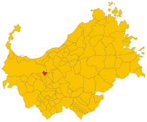
Map of comune of Muros (province of Sassari, region Sardinia, Italy) - 2016.svg
8,800 × 7,300; 248 KB
8,800 × 7,300; 248 KB
1 reference
Muros (Italy)
0 references
.JPG)


_-_2016.svg)
.JPG)
11.23 square kilometre
9 October 2011
5 references
Superficie di Comuni Province e Regioni italiane al 9 ottobre 2011 (Italian)
16 March 2019
858
1 January 2017
1 reference
843
1 January 2018
4 references
Popolazione Residente al 1° Gennaio 2018 (Italian)
16 March 2019
SS
0 references
Identifiers
1980480907
0 references
Q289353
0 references